Thurston_Lava_Tube,_Big_Island.jpg

Size of this preview:
800 × 535 pixels
.
Other resolutions:
320 × 214 pixels
|
640 × 428 pixels
|
1,024 × 685 pixels
|
1,280 × 856 pixels
|
2,560 × 1,711 pixels
|
4,272 × 2,856 pixels
.
Summary
| Camera location |
|
View this and other nearby images on: OpenStreetMap |
|
|---|
| Description |
English:
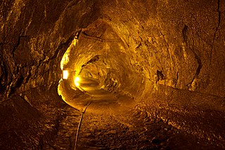
Thurston Lava Tube at Hawaii Volcanoes National Park, Big Island, Hawaii. The step mark on the right wall indicates the depth at which the lava flowed for a period of time.
|
| Date | |
| Source | Own work |
| Author | Frank Schulenburg |
|
Licensing
I, the copyright holder of this work, hereby publish it under the following license:
This file is licensed under the
Creative Commons
Attribution-Share Alike 3.0 Unported
license.
-
You are free:
- to share – to copy, distribute and transmit the work
- to remix – to adapt the work
-
Under the following conditions:
- attribution – You must give appropriate credit, provide a link to the license, and indicate if changes were made. You may do so in any reasonable manner, but not in any way that suggests the licensor endorses you or your use.
- share alike – If you remix, transform, or build upon the material, you must distribute your contributions under the same or compatible license as the original.
|
|
This image has been assessed using the
Quality image guidelines
and is considered a
Quality image
.
|