Transcaucasia_Map.png
Size of this preview:
800 × 400 pixels
.
Other resolutions:
320 × 160 pixels
|
640 × 320 pixels
|
1,000 × 500 pixels
.

|
This
map
image could be re-created
using
vector graphics
as an
SVG
file
. This has several advantages; see
Commons:Media for cleanup
for more information. If an SVG form of this image is available, please upload it and afterwards replace this template with
{{

vector version available

|

new image name

}}
.
It is recommended to name the SVG file “Nagorno-Karabakh conflict map (pre-2020).svg”—then the template Vector version available (or Vva ) does not need the new image name parameter. |
Summary
| Description |
English:
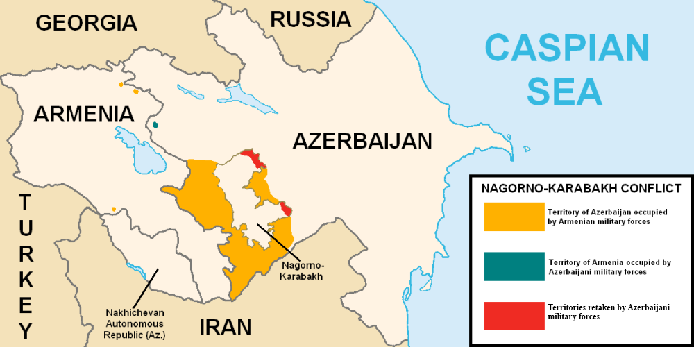
This map describes the situation in the disputed Nagorno-Karabakh region prior to the 2020 war. The region is internationally recognized as part of Azerbaijan but partly governed by the de facto independent Republic of Artsakh. The image is a modified version of MarshallBagramyan's map.
|
| Date | |
| Source | File:Artsakh Occupation Map.png |
| Author | Elnur Hajiyev |
Licensing
|
|
This work has been released into the
public domain
by its author,
Elnurvl
. This applies worldwide.
In some countries this may not be legally possible; if so:
|