Transsib_international.svg

Size of this PNG preview of this SVG file:
800 × 566 pixels
.
Other resolutions:
320 × 226 pixels
|
640 × 453 pixels
|
1,024 × 724 pixels
|
1,280 × 905 pixels
|
2,560 × 1,811 pixels
|
2,293 × 1,622 pixels
.
Summary
| Description |
Deutsch:
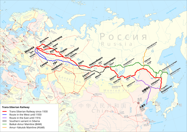
Karte der Transsibirische Eisenbahn. Rot: Streckenführung der Transsibirische Eisenbahn ab 1930. Blau: Streckenführung im Westen vor 1930. Violett: Streckenführung im Osten bis 1916. Schwarz: Südvariante in Sibirien. Grün: Baikal–Amur-Magistrale. Orange: Amur—Yakutsk-Magistrale. Internationale Version mit Namen in der Landessprache und englischer Übersetzung.
English:
Trans-Siberian Railroad map. Red: Route of the Trans-Siberian Railway since 1930. Blue: Route in the west before 1930. Violet: Route in the east until 1916. Black: Southern variant in Siberia. Green: Baikal–Amur Mainline. Orange: Amur–Yakutsk Mainline. International Version with Names in local language and English translation.
Equidistant conic projection: Central meridian : * E: 100.0° E Standard parallels: * 1: 49.0° N * 2: 59.0° N Projection Code used for QGIS: * +proj=eqdc +lon_0=100e +lat_l=49n +lat_2=59n |
| Date | |
| Source |
Map was created using:
|
| Author |
|
|
Permission
( Reusing this file ) |
|
| Other versions |
|


|
|
This work is licensed under the Open Database License ( summary ). |