Trebizond1400.png
No higher resolution available.
Summary
| Description |
English:
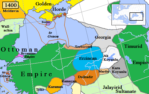
Trebizond and surrounding states in Anatolia/Caucasus in AD 1400.
(Partially based on Euratlas map of Europe, 1400, improved since
Koza Yayınları Tarih Atlası
sf.42;
Kanaat Yayınları Tarih Atlası
sf.28; Mutafian, Claude & Van Lauwe, Eric:
Atlas historique de l'Arménie
, Autrement publ., coll. «Atlas/Memoires», Paris 2001,
ISBN
2-7467-0100-6
and since the graphic style of
[1]
)
|
| Date | |
| Source | Own work |
| Author | Gabagool |
![[1]](http://vignette3.wikia.nocookie.net/genealogy/images/c/cf/Trebizond1300.png/revision/latest/thumbnail-down/width/340/height/340?cb=20110516182142)

|
This
historical map
image could be re-created
using
vector graphics
as an
SVG
file
. This has several advantages; see
Commons:Media for cleanup
for more information. If an SVG form of this image is available, please upload it and afterwards replace this template with
{{

vector version available

|

new image name

}}
.
It is recommended to name the SVG file “Trebizond1400.svg”—then the template Vector version available (or Vva ) does not need the new image name parameter. |
Licensing
I, the copyright holder of this work, hereby publish it under the following license:
This file is licensed under the
Creative Commons
Attribution 3.0 Unported
license.
-
You are free:
- to share – to copy, distribute and transmit the work
- to remix – to adapt the work
-
Under the following conditions:
- attribution – You must give appropriate credit, provide a link to the license, and indicate if changes were made. You may do so in any reasonable manner, but not in any way that suggests the licensor endorses you or your use.