Triple_Occupation_of_Greece.png

Size of this preview:
588 × 600 pixels
.
Other resolutions:
235 × 240 pixels
|
471 × 480 pixels
|
899 × 917 pixels
.
Summary
| Description |
English:
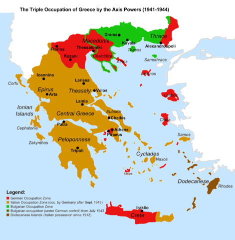
Map of the 1941-1944 Axis Occupation of Greece. Depicted are the three occupation zones, plus the geographic regions and major urban centres.
|
| Date | |
| Source |
Own work based on: Gr-triple-occupation.png , with minor corrections in the territorial extent of the occupation zones, and added information. References:
|
| Author | Cplakidas |
| Other versions |
[
]
|


_-fr.png)


Licensing

|
Permission is granted to copy, distribute and/or modify this document under the terms of the GNU Free Documentation License , Version 1.2 or any later version published by the Free Software Foundation ; with no Invariant Sections, no Front-Cover Texts, and no Back-Cover Texts. A copy of the license is included in the section entitled GNU Free Documentation License . |
|
|
This file is licensed under the Creative Commons Attribution-Share Alike 3.0 Unported license. | |
|
||
| This licensing tag was added to this file as part of the GFDL licensing update . |