US_Secession_map_1863_(BlankMap_derived).png

Size of this preview:
800 × 488 pixels
.
Other resolutions:
320 × 195 pixels
|
640 × 390 pixels
|
841 × 513 pixels
.

|
This
locator map
image could be re-created
using
vector graphics
as an
SVG
file
. This has several advantages; see
Commons:Media for cleanup
for more information. If an SVG form of this image is available, please upload it and afterwards replace this template with
{{

vector version available

|

new image name

}}
.
It is recommended to name the SVG file “US Secession map 1863 (BlankMap derived).svg”—then the template Vector version available (or Vva ) does not need the new image name parameter. |
Summary
| Description |
English:
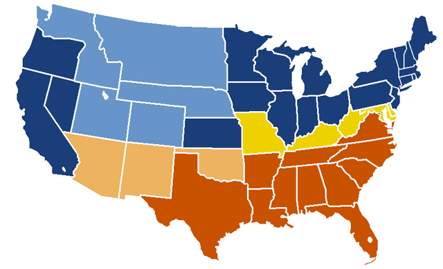
United States map of 1863, show affiliation of states and territories regarding the Secession War (Civil War.) Legend:
Union states
Union territories not permitting slavery
Border Union states, permitting slavery
Confederate states
Union territories permitting slavery (claimed by Confederacy)
|
| Date | original upload date: 19:04, 24 February 2007 |
| Source |
|
| Author | w:en:Porsche997SBS ( talk | contribs ) |
Licensing
|
|
This map was obtained from an edition of the
National Atlas of the United States
. Like almost all works of the U.S. federal government, works from the
National Atlas
are in the
public domain
in the United States.
Online access: NationalAtlas.gov | 1970 print edition: Library of Congress , Perry-Castañeda Library
|
|
Original upload log
| date/time | username | resolution | size | edit summary |
|---|---|---|---|---|
| 19:04, 24 February 2007 | w:en:User:Porsche997SBS | 841×513 | 24 KB | trimming blankness |
| 18:59, 24 February 2007 | w:en:User:Porsche997SBS | 841×580 | 25 KB | don't need that |
| 18:55, 24 February 2007 | w:en:User:Porsche997SBS | 841×580 | 29 KB | format based on [http://en.wikipedia.org/wiki/Image:BlankMap-USA-states.PNG this image]; information from [http://en.wikipedia.org/wiki/Image:US_Secession_map_1865.svg this image]; see description pages there |
Image description page history
| link | date/time | username | edit summary |
|---|---|---|---|
| http://en.wikipedia.org/w/index.php?title=Image:US_Secession_map_1865_(BlankMap_derived).PNG&redirect=no&oldid=110635613 | 07:40, 10 September 2007 | w:en:User:Dmcdevit | |
| http://en.wikipedia.org/w/index.php?title=Image:US_Secession_map_1865_(BlankMap_derived).PNG&redirect=no&oldid=110635613 | 19:02, 24 February 2007 | w:en:User:Porsche997SBS | |
| http://en.wikipedia.org/w/index.php?title=Image:US_Secession_map_1865_(BlankMap_derived).PNG&redirect=no&oldid=110634272 | 18:55, 24 February 2007 | w:en:User:Porsche997SBS | (format based on [http://en.wikipedia.org/wiki/Image:BlankMap-USA-states.PNG this image]; information from [http://en.wikipedia.org/wiki/Image:US_Secession_map_1865.svg this image]; see description pages there) |
.PNG&redirect=no&oldid=110635613)
.PNG&redirect=no&oldid=110634272)