UWETilt.gif
No higher resolution available.
Summary
| Description |
English:
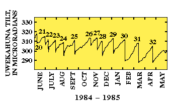
This graph shows a one-year record of tilt from the Uwekahuna tiltmeter located on rim of Kilauea's caldera. When the tiltmeter record showed an increase in slope angle (microradians) the ground was tilting away from the caldera, which indicates the summit area was inflating with magma. Then, when lava within Pu`u `O`o filled and overflowed the crater or began fountaining, the summit tiltmeter record suddenly showed a decrease in slope angle or deflation. After the eruption, the tiltmeter once again recorded a steady outward tilt.
|
| Date | before 31 July 2007 |
| Source | USGS graph of Kilauea volcano tiltmeter |
| Author | USGS |
Licensing
|
|
This image is in the
public domain
in the United States because it only contains materials that originally came from the
United States Geological Survey
, an agency of the
United States Department of the Interior
. For more information, see
the official USGS copyright policy
.
|
|