Ukraina1919.jpg

Size of this preview:
800 × 513 pixels
.
Other resolutions:
320 × 205 pixels
|
640 × 410 pixels
|
960 × 615 pixels
.
Summary
| Description |
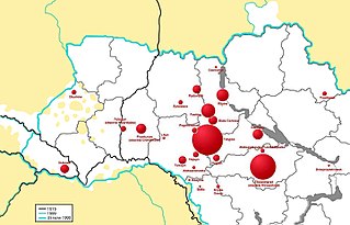
English:
Location of selected pogroms of Ukrainian Jews in the years 1918-1920, taking into account the number of victims. Black: 1919 borders. Green: actual borders (since 1991). Blue: actual ukrainian border. White: ukrainian inhabitants. Infographic made on the basis of the table at the address:
http://pl.wikipedia.org/wiki/Pogromy_Żydów_na_Ukrainie_(1918-1920)#Przebieg_wybranych_pogrom.C3.B3w
,
Polski:
Lokalizacja wybranych pogromów Żydów ukraińskich w latach 1918-1920 z uwzględnieniem liczby ofiar. Czarny: 1919 granic. Zielony: rzeczywiste granice (od 1991 r.). Niebieski: właściwa granica ukraińska. Biały: mieszkańcy Ukrainy. Infografika wykonana w oparciu o tabelę zamieszczoną pod adresem:
http://pl.wikipedia.org/wiki/Pogromy_Żydów_na_Ukrainie_(1918-1920)#Przebieg_wybranych_pogrom.C3.B3w
|
| Date | |
| Source | Sent to me personally by the author. |
| Author | Wojciech Winkler |
Licensing
|
|
This file is made available under the Creative Commons CC0 1.0 Universal Public Domain Dedication . |
|
The person who associated a work with this deed has dedicated the work to the
public domain
by waiving all of their rights to the work worldwide under copyright law, including all related and neighboring rights, to the extent allowed by law. You can copy, modify, distribute and perform the work, even for commercial purposes, all without asking permission.
|