United_Kingdom_EU_referendum_2016_voting_regions_results.svg

Size of this PNG preview of this SVG file:
388 × 600 pixels
.
Other resolutions:
155 × 240 pixels
|
310 × 480 pixels
|
497 × 768 pixels
|
663 × 1,024 pixels
|
1,325 × 2,048 pixels
|
886 × 1,369 pixels
.
Summary
| Description |
English:
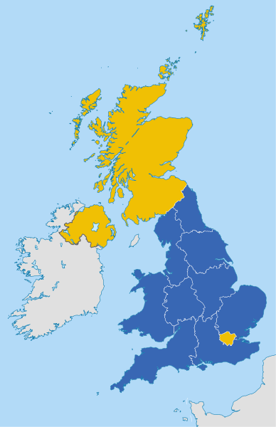
Map of the United Kingdom showing the regional counting areas for the European Union membership referendum, 2016.
Remain
Leave
Deutsch:
Karte des Vereinigten Königreichs mit den Ergebnissen des
Referendums über den Verbleib des Vereinigten Königreichs in der Europäischen Union 2016
.
Verbleib in der EU
Ausscheiden aus der EU
|
||
| Date | |||
| Source |
This file was derived from:
United Kingdom NUTS location map.svg
|
||
| Author |
|
||
|
Permission
( Reusing this file ) |
I, the copyright holder of this work, hereby publish it under the following licenses:
This file is licensed under the
Creative Commons
Attribution-Share Alike 4.0 International
license.
You may select the license of your choice.
|
||
| Other versions |

|
||
| SVG development |
