Vincenzo_Coronelli00.jpg

Size of this preview:
798 × 600 pixels
.
Other resolutions:
319 × 240 pixels
|
639 × 480 pixels
|
902 × 678 pixels
.
Summary
| Description |
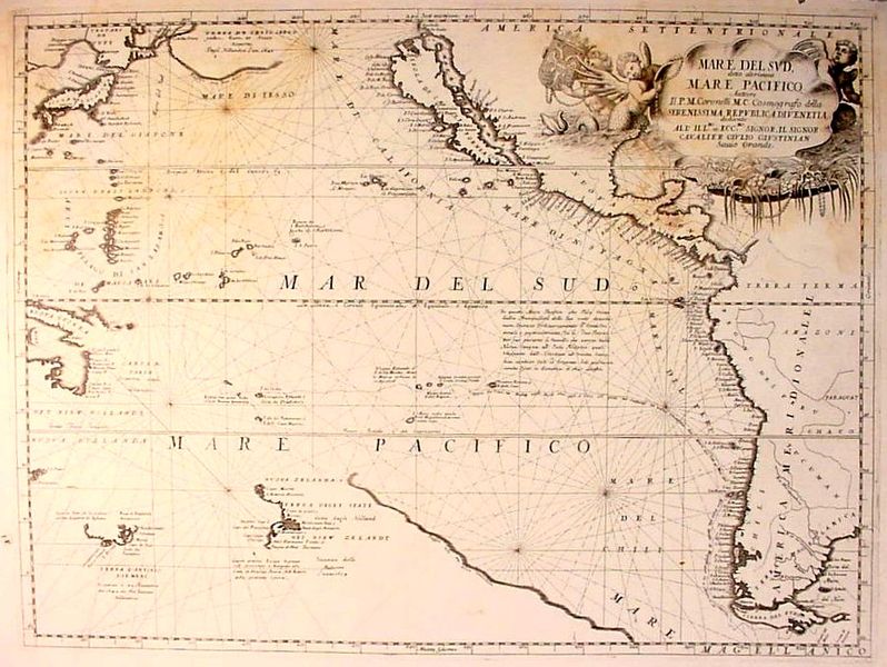
English:
Map of
Pacific Ocean
— "Mare Del Sud, detto altrimenti Mare Pacifico."
|
| Date | between 1689 and 1700 |
| Source | http://www.philaprintshop.com/oceans.html |
| Author | Vincenzo Coronelli (1650-1718) |
|
Permission
( Reusing this file ) |
Public domain |
Notes
- "This map shows the western coast of the Americas, including a nice example of the famous cartographic myth of California as an island.
- To the west of this is the large, vaguely drawn "Terra De Iesso," reflecting the current unknown state of the lands to the north of Japan and west of America.
- Coronelli shows the 1615-1617 route of Jacob Lemaire round Cape Horn and west across the Pacific. Lemaire was the first to sail south of Tierra del Fuego , proving that it was not part of the great, unknown Southern Continent.
- The map is particularly interesting for its early and important depiction of Australia and New Zealand . Part of Australia, including "Nuova Hollanda" in the north and "Terra D'Antonio Diemens" ( Tasmania ) in the south are indicated, as is part of the western coast of New Zealand. Not realizing New Zealand's insular nature, Coronelli connects this coastline with an eastern coast, "not yet well know" which runs off towards Tierra del Fuego—part of that hypothetical southern continent."
Licensing
|
|
This work is in the public domain in its country of origin and other countries and areas where the copyright term is the author's life plus 100 years or fewer . |
| This file has been identified as being free of known restrictions under copyright law, including all related and neighboring rights. | |