W-RSimpleMap.gif

Size of this preview:
432 × 599 pixels
.
Other resolutions:
173 × 240 pixels
|
346 × 480 pixels
|
554 × 768 pixels
|
738 × 1,024 pixels
|
1,960 × 2,718 pixels
.
Summary
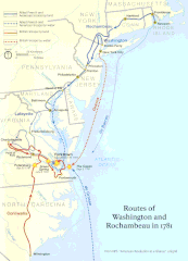
| Description | Official National Park Service map of the Washington-Rochambeau Revolutionary Route |
| Date | |
| Source | http://www.nps.gov/boso/w-r |
| Author | National Park Service |
|
Permission
( Reusing this file ) |
"The maps at this site are in the public domain. You may use National Park Service maps provided that you agree to assume complete legal responsibility for problems resulting from their use. Although National Park Service maps are easy to modify, understand that modifications can adversely alter the meaning and accuracy of the original data. Law prohibits you from using the National Park Service seal or claiming National Park Service endorsement with downloaded maps." [1] |
Licensing
|
|
This image or media file contains material based on a work of a National Park Service employee, created as part of that person's official duties. As a work of the U.S. federal government , such work is in the public domain in the United States. See the NPS website and NPS copyright policy for more information. |
|

|
This
map
image could be re-created
using
vector graphics
as an
SVG
file
. This has several advantages; see
Commons:Media for cleanup
for more information. If an SVG form of this image is available, please upload it and afterwards replace this template with
{{

vector version available

|

new image name

}}
.
It is recommended to name the SVG file “W-RSimpleMap.svg”—then the template Vector version available (or Vva ) does not need the new image name parameter. |