WWI-re.png
Size of this preview:
800 × 338 pixels
.
Other resolutions:
320 × 135 pixels
|
640 × 270 pixels
|
1,480 × 625 pixels
.
Summary
| Description |
Afrikaans
:
Kaart van die wêreld wat die deelnemers in die Eerste Wêreldoorlog:
Geallieerdes (sommige tot die oorlog toegetree of daarna val uit)
Sentrale Moondhede
Neutrale Lande
Bahasa Indonesia
:
Peta negara-negara yang berpartisipasi dalam Perang Dunia I:
Kekuatan Entente dan Sekutu (nantinya sebagian ikut ke dalam perang atau mundur)
Kekuatan Tengah
Negara Netral
Bahasa Melayu
:
Peta Dunia menunjukkan peserta-peserta dalam Perang Dunia I:
Kelulusan antara dua negara dan Berikat (beberapa memasuki peperangan atau tercicir kemudian)
Kuasa-kuasa pusat
Negara-negara berkecuali
Català
:
Mapa del Món que mostra als participants en la Primera Guerra Mundial:
Entesa i els Aliats (alguns van entrar en la guerra o han abandonat més tard)
Potències Centrals
Països Neutrals
Dansk
:
Kort over verden viser deltagerne i 1. verdenskrig:
Ententemagterne (nogle gik ind i krigen eller droppet ud senere)
Centralmagterne
Neutrale Lande
Deutsch
:
Karte der am Ersten Weltkrieg beteiligten Länder:
Entente und Alliierte (einige sind später in den Krieg eingetreten oder ausgetreten)
Mittelmächte
Neutrale Länder
English
:
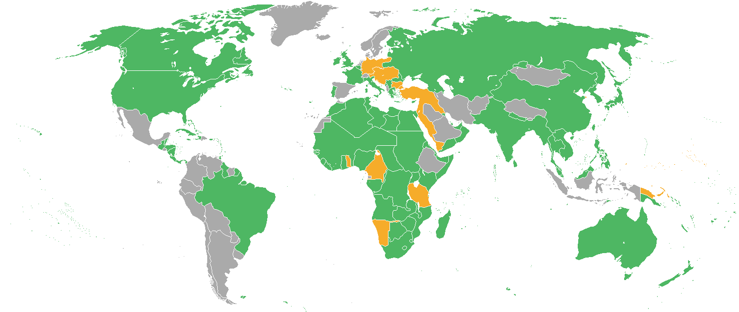
Map of the World showing the participants in World War I:
Entente
and Allies (some entered the war or dropped out later)
Neutral Countries
Español
:
Mapa del Mundo que muestra a los participantes en la Primera Guerra Mundial:
Entente y los Aliados (algunos entraron en la guerra o abandonaron más tarde)
Potencias Centrales
Países Neutrales
Français
:
Carte du monde montrant les participants à la Première Guerre mondiale :
Alliés
(certains sont entrés ou sorti de la guerre plus tard)
pays neutres
Italiano
:
Mappa del Mondo mostrando i partecipanti nella prima guerra mondiale:
Dell'Intesa e gli alleati (alcuni entrarono in guerra o caduto in un secondo momento)
Imperi Centrali
Paesi Neutrali
Latina
:
Bellum Orbis Terrarum Primum participes ostendens:
Potestates Foederatae (ex alia ingressus post bellum omitti)
Potestates Axiales
Regionum Neutrali
Magyar
:
Világtérkép mutatja a résztvevők az I. világháborúban:
Antant és a szövetségesek (néhány belépett a háborúba, vagy kimaradt később)
Központi Hatalmak
Semleges Országok
Nederlands
:
Kaart van de Wereld met de deelnemers in de Eerste Wereldoorlog:
Geallieerden (sommige kwamen er later bij of verlieten de de oorlog eerder)
Centrale Mogendheden
Neutrale Landen
Română
:
Hartă a lumii reprezentând participanții la Primul Război Mondial:
Antanta și aliații săi (unele au intrat în război sau au abandonat mai târziu)
Puterile Centrale
Țări neutre
Slovenčina
:
Mapa sveta ukazuje účastníkov prvej svetovej vojny:
Spojenectvo a spojencami (niektoré vstúpili do vojny, alebo vypadol neskôr)
Centrálne Sily
Neutrálnych Krajinách
Suomi
:
Maailman kartta osoittaa osallistujille maailmansota:
Ympärysvallat (osa liittyi sotaan tai luopui sodasta myöhemmin)
Keskusvallat
Puolueettomat
Svenska
:
Världskarta som visar deltagarna i första världskriget:
Ententen och dess allierade (vissa gick med eller lämnade kriget senare)
Centralmakterna
Neutrala länder
Türkçe
:
I. Dünya Savaşı'nda katılımcılara gösteren Dünya Haritası:
İtilaf ve Müttefikler (bazı savaşa girdi ya da daha sonra düştü)
Ittifak Devletleri
Nötr Ülkeler
Русский
:
На карте мира указанны участники Первой мировой войны:
Антанта и союзники (некоторые вступили до войны или позднее вышли)
Центральные державы
Нейтральные страны
Српски / srpski
:
Карта света показује учесницима у Првом светском рату:
Антанте и савезници (неке ушле у рат или испала касније)
Централне силе
Неутралне земље
ქართული
:
ವಿಶ್ವಯುದ್ಧದ ಭಾಗವಹಿಸುವವರ ತೋರಿಸುವ ವಿಶ್ವ ನಕ್ಷೆ:
ರಾಷ್ಟ್ರಗಳ ಮತ್ತು ಮಿತ್ರರಾಷ್ಟ್ರಗಳು (ಕೆಲವು ಯುದ್ಧ ನಮೂದಿಸಿದ ಅಥವಾ ನಂತರ ಬಿಟ್ಟ)
ಕೇಂದ್ರ ಶಕ್ತಿಗಳು
ನ್ಯೂಟ್ರಲ್ ದೇಶಗಳು
தமிழ்
:
உலக போர் நான் பங்கேற்பாளர்கள் காட்டும் உலக வரைபடம்:
நாடுகளுக்கு இடையில் நட்புறவு மற்றும் நேச நாடுகள் (சில போர் உள்ளிட்ட அல்லது பிறகு கைவிடப்பட்டது)
மத்திய பவர்ஸ்
நடுநிலை நாடுகள்
ไทย
:
แผนที่โลกแสดงฝ่ายในสงครามโลกครั้งที่หนึ่ง:
ฝ่ายสัมพันธมิตร (บางประเทศเข้าร่วมหรือถอนตัวในภายหลัง)
ฝ่ายมหาอำนาจกลาง
ประเทศที่เป็นกลาง
한국어
:
제 1차 세계 대전의 참가자를 보여주는 세계지도 :
연합군 (일부는 전쟁중 참가하거나 전쟁을 중단함(예:러시아 제국))
동맹국
중립국
日本語
:
第一次世界大戦での参加国を示す世界地図:
協商国と同盟国(一部は途中参加、あるいは離脱)
中央同盟国
中立国
中文(简体)
:
第一次世界大战参战国地图:
协约国(参战或中途参战)
同盟国
中立国家
中文(繁體)
:
第一次世界大戰參戰國地圖:
協約國(參戰或中途參戰)
同盟國
中立國家
עברית
:
מפת העולם המציגה את המשתתפים במלחמת העולם הראשונה:
ההסכמה ובעלות הברית (כ נכנסה למלחמה או נשרו לאחר מכן)
מרכז סמכויות
ניטרלי מדינות
العربية
:
:خريطة للعالم تظهر للمشاركين في الحرب العالمية الأولى
الوفاق وحلفائها (بعض دخلت الحرب أو تسربوا في وقت لاحق)
وسط القوى
البلدان المحايدة
|
| Date | |
| Source | Own work (originally at en.wikipedia) |
| Author | Thomashwang |

|
This
military map
image could be re-created
using
vector graphics
as an
SVG
file
. This has several advantages; see
Commons:Media for cleanup
for more information. If an SVG form of this image is available, please upload it and afterwards replace this template with
{{

vector version available

|

new image name

}}
.
It is recommended to name the SVG file “WWI-re.svg”—then the template Vector version available (or Vva ) does not need the new image name parameter. |
Licensing
Thomashwang
at the
English-language Wikipedia
, the copyright holder of this work, hereby publishes it under the following license:

|
Permission is granted to copy, distribute and/or modify this document under the terms of the GNU Free Documentation License , Version 1.2 or any later version published by the Free Software Foundation ; with no Invariant Sections, no Front-Cover Texts, and no Back-Cover Texts. A copy of the license is included in the section entitled GNU Free Documentation License . |
|
|
This file is licensed under the Creative Commons Attribution-Share Alike 3.0 Unported license. | |
| Attribution: Thomashwang | ||
|
||
| This licensing tag was added to this file as part of the GFDL licensing update . |