Wawadit'la(Mungo_Martin_House)_a_Kwakwaka'wakw_big_house.jpg

Summary
|
|
This is a
retouched picture
, which means that it has been digitally altered from its original version. Modifications:
This image was created by stitching together 28 images taken at different angles. Saturation, brightness and contrast adjusted. White balance adjusted from RAW.
.
|
| Description |
English:
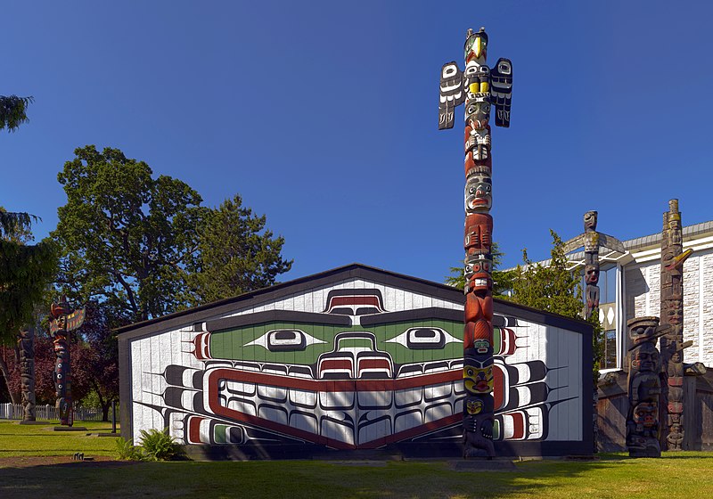
Wawadit'la, also known as Mungo Martin House, a Kwakwaka'wakw "big house", with heraldic pole. Built by Chief Mungo Martin in 1953. Located at Thunderbird Park in Victoria, British Columbia.
(Description taken from here )
Français :
Wawadit'la, ou la maison de Mungo Martin, une "Grande maison" des Kwakwaka'wakw, avec ses totems. Monuments construits par le chef sculpteur Mungo Martin assisté de David Martin et Mildred Hunt en 1953 à Thunderbierd park, Victoria, en Colombie Britannique.
|
| Date | Taken June 20th 2007, finished June 21st, 2007 |
| Source | Own work |
| Author | HighInBC Attribute to Ryan Bushby |
| Object location |
|
View this and other nearby images on: OpenStreetMap |
|
|---|
http://www.royalbcmuseum.bc.ca/exhibits/tbird-park/index.html
House built by Mungo Martin and David Martin with carpenter Robert J. Wallace. Based on Chief Nakap'ankam's house in Tsaxis (Fort Rupert). The house "bears on its house-posts the hereditary crests of Martin's family." It continues to be used for ceremonies with the permission of Chief Oast'akalagalis 'Walas 'Namugwis (Peter Knox, Martin's grandson) and Mable Knox. Pole carved by Mungo Martin, David Martin and Mildred Hunt. "Rather than display his own crests on the pole, which was customary, Martin chose to include crests representing the A'wa'etlala, Kwagu'l, 'Nak'waxda'xw and 'Namgis Nations. In this way, the pole represents and honours all the Kwakwaka'wakw people."
| Warning | The original file is very high-resolution. It might not load properly or could cause your browser to freeze when opened at full size. |
|---|
|

_a_Kwakwaka%27wakw_big_house.jpg¶ms=048.420000_N_-123.366620_E_globe:Earth_class:object_type:object_region:CA-BC_&language=en)
_a_Kwakwaka%27wakw_big_house.jpg)
|
|
This image was selected as
picture of the day
on Wikimedia Commons for
18 August 2007
. It was captioned as follows:
English:
Wawadit'la with
heraldic pole
, built by Chief Mungo Martin in 1953 at Thunderbird Park in
Victoria
,
British Columbia
Canada
.
Other languages:
Asturianu
:
Wawadit'la con un totem heráldicu, costruyíu pol Xefe Mungo Martin en
1953
nel Thunderbird Park, Victoria, Columbia Británica,
Canadá
.
Deutsch
:
Wawadit'la, ein „big house“ der
Kwakiutl
, mit
Wappenpfahl
im Thunderbird-Park in
Victoria
, Britisch-Kolumbien, Kanada.
English
:
Wawadit'la with
heraldic pole
, built by Chief Mungo Martin in 1953 at Thunderbird Park in
Victoria
,
British Columbia
Canada
.
Español
:
Wawadit'la con un tótem heráldico, construido por el Jefe Mungo Martin en 1953 en el Thunderbird Park,
Victoria
,
Columbia Británica
,
Canadá
.
Français
:
Les
totems
érigés autour de la
case
communautaire villageoise (
wawadit’la
) ornés de symboles
héraldiques
, construits par le chef
nord-amérindien
Mungo Martin en 1953 au
Thunderbird Park
de
Victoria
en
Colombie-Britannique
(
Canada
).
Íslenska
:
Tótemsúla
, reist af
Mungo Martin
árið
1953
í
Thunderbird-þjóðgarðinum
í
Bresku Kólumbíu
í
Kanada
.
Italiano
:
Wawadit'la con totem, costruito dal capo Mungo Martin nel 1953 e situato in Thunderbird Park,
Victoria
,
Columbia Britannica
Canada
.
Magyar
:
Wawadit'la totemoszloppal, (emelte Mungo Martin főnök 1953-ban - Thunderbird Park,
kanadai
Brit Kolumbia)
Nederlands
:
De
Wawadit'la
, een Kwakwaka'wakw "big house" dat werd gebouwd in 1953 door
stamhoofd
Mungo Martin met
totempalen
rondom, in het Thunderbird Park van de stad
Victoria
in de
Canadese
provincie
Brits-Columbia
Polski
:
Indiański słup
totemowy
i Wawadit'la zbudowany przez Wodza Mungo Martina w 1953 roku w Parku Thunderbird w
Kolumbii Brytyjskiej
w
Kanadzie
.
Português
:
Wawadit'la é uma casa com um
poste totem
. Esta localizada no Parque Thunderbird em
Victoria
,
Colúmbia Britânica
.
Slovenčina
:
Wawadit'la s indiánskym totemom, ktorú postavil náčelník Mungo Martin v roku 1953 v Thunderbird Parku,
Victoria
,
Britská Kolumbia
,
Kanada
Беларуская
:
Дом "Вавадзіт'ла" і
татэмны слуп
, збудаваныя Мунга Марцінам у 1953 (Тандарбёрд-Парк,
Брытанская Калумбія
,
Канада
).
Русский
:
Wawadit'la
с
тотемным столбом
, построенный вождём Мунго Мартином в 1953 году в Тандерберд парке в
Виктории
(
Британская Колумбия
,
Канада
).
Українська
:
Індіанський тотемний стовп та «Вавадітла», на мові індіанців племені квакіутл — великий дім. Збудовані вождем Мунґо Мартін 1953 року у парку-музеї Thunderbird, що у м. Вікторія, Британська Колумбія, Канада.
日本語
:
マンゴ・マーティンの家。トーテムポールが置かれている。1953年ネイティブアメリカンの酋長マンゴ・マーティンによって
カナダ
、
ブリティッシュコロンビア州
ヴィクトリア
のサンダーバードパークに建てられる。
|
Licensing
-
You are free:
- to share – to copy, distribute and transmit the work
- to remix – to adapt the work
-
Under the following conditions:
- attribution – You must give appropriate credit, provide a link to the license, and indicate if changes were made. You may do so in any reasonable manner, but not in any way that suggests the licensor endorses you or your use.
- share alike – If you remix, transform, or build upon the material, you must distribute your contributions under the same or compatible license as the original.
|
|
This image has been assessed using the
Quality image guidelines
and is considered a
Quality image
.
|