Yom_Kippur_War_map.svg

Size of this PNG preview of this SVG file:
398 × 599 pixels
.
Other resolutions:
159 × 240 pixels
|
319 × 480 pixels
|
510 × 768 pixels
|
680 × 1,024 pixels
|
1,361 × 2,048 pixels
|
400 × 602 pixels
.
Summary
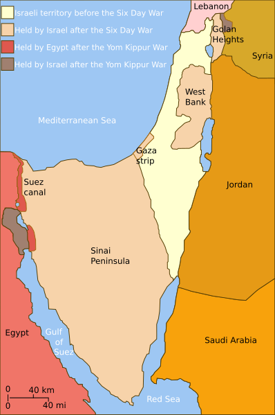
| Description | Self-made line drawing of a map of Israel's territories before and after the Yom Kippur War . |
| Date | |
| Source | Source of line drawing: Now-deleted image Jom kippur war.jpg which was originally uploaded to the polish Wikipedia at Jom kippur war.jpg -- Ministerstwo Spraw Zagranicznych Izraela, za zgodÄ… Ambasady Izraela w Polsce. -- Ministry of Foreign Affairs of Israel, with the permission of Israel Embassy in Poland |
| Author | Raul654 |
| Other versions |
[
]
|
| SVG development |


|
This SVG file contains embedded text that can be translated into your language, using any capable SVG editor, text editor or the SVG Translate tool . For more information see: About translating SVG files . |
Licensing
This file is licensed under the
Creative Commons
Attribution-Share Alike 2.5 Generic
license.
-
You are free:
- to share – to copy, distribute and transmit the work
- to remix – to adapt the work
-
Under the following conditions:
- attribution – You must give appropriate credit, provide a link to the license, and indicate if changes were made. You may do so in any reasonable manner, but not in any way that suggests the licensor endorses you or your use.
- share alike – If you remix, transform, or build upon the material, you must distribute your contributions under the same or compatible license as the original.