Yugoslavia_proposed_banovinas_1939_1941.png
Size of this preview:
678 × 599 pixels
.
Other resolutions:
272 × 240 pixels
|
543 × 480 pixels
|
869 × 768 pixels
|
1,051 × 929 pixels
.
Summary
| Description |
English:
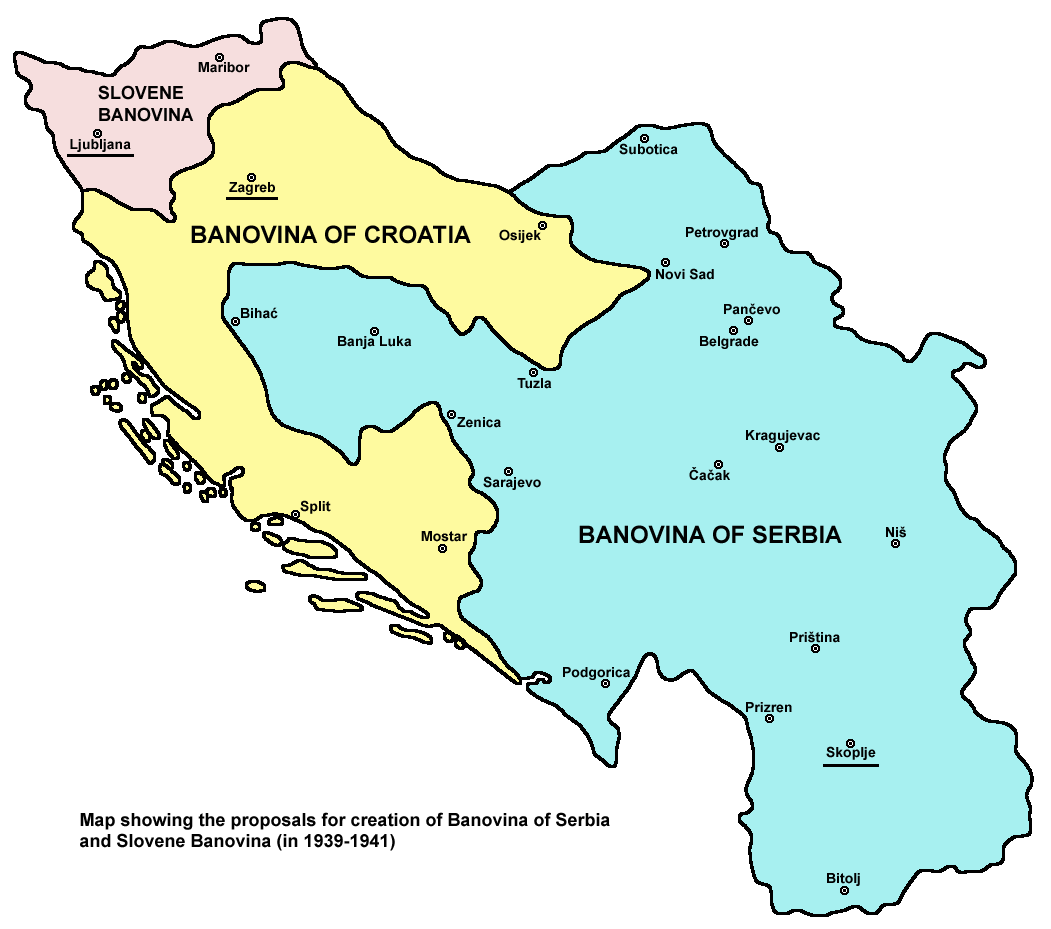
Map showing the proposals for creation of Banovina of Serbia and Slovene Banovina (in 1939-1941).
Српски / srpski:
Mapa koja pokazuje predloge o stvaranju Banovine Srbije i Slovenačke banovine (1939-1941).
|
| Date | |
| Source | Own work |
| Author | PANONIAN |
Licensing
I, the copyright holder of this work, hereby publish it under the following license:
|
|
This file is made available under the Creative Commons CC0 1.0 Universal Public Domain Dedication . |
|
The person who associated a work with this deed has dedicated the work to the
public domain
by waiving all of their rights to the work worldwide under copyright law, including all related and neighboring rights, to the extent allowed by law. You can copy, modify, distribute and perform the work, even for commercial purposes, all without asking permission.
|
References
Info about proposed Banovina of Serbia and Slovene Banovina:
- Contemporary Yugoslavia: twenty years of Socialist experiment, Wayne S. Vucinich, Jozo Tomasevich, Stanford University, University of California Press, 1969, page 31.
- Worldmark Encyclopedia of the Nations: Europe, Gale Group, 2001, page 102.
- Slovenia in European affairs: reflections on Slovenian political history, John A. Arnez, League of CSA, 1958, page 70.
- Zbornik Matice srpske za istoriju, Tomovi 59-60, Matica srpska (Novi Sad, Serbia), Odeljenje za društvene nauke, 1999, page 134.
- Elusive compromise: a history of interwar Yugoslavia, Dejan Djokić, Columbia University Press, 2007, page 233.
- Slovene studies: journal of the Society for Slovene Studies, Tomovi 18-19, Society for Slovene Studies, The Society, 1996, pages 73, 75, 76.
- http://htmlimg3.scribdassets.com/4w278zkqbk1ie5xm/images/309-2bf7bed934.jpg
- https://www.scribd.com/doc/88150090/povijesni-atlas-bih-zijad-%C5%A0ehi%C4%87-i-ibrahim-tepi%C4%87
Maps of the Kingdom of Yugoslavia in 1939-1941 (used as a base for this work):
- http://terkepek.adatbank.transindex.ro/kepek/netre/178.gif
- http://www.hrvatski-vojnik.hr/hrvatski-vojnik/0482005/bpictures/manovina%20Hrvatska.jpg
- http://www.hic.hr/dom/288/images/pod01.jpg archive copy at the Wayback Machine
- http://forum.net.hr/cfs-filesystemfile.ashx/__key/CommunityServer.Discussions.Components.Files/15/7041.Banovina-b.JPG
- http://www.croatianviewpoint.com/Content-Folder/Maps/3map.jpg
- http://www.plbih.info/cms/typo3temp/pics/bd12688935.jpg
- http://i252.photobucket.com/albums/hh13/tomba17_photos/Geopoliticke%20zemljovide/banovinahrv.jpg (Note: image from Photobucket used only as a secondary reference)