Zealandia-Continent_map_en.svg

Size of this PNG preview of this SVG file:
547 × 599 pixels
.
Other resolutions:
219 × 240 pixels
|
438 × 480 pixels
|
701 × 768 pixels
|
935 × 1,024 pixels
|
1,870 × 2,048 pixels
|
789 × 864 pixels
.

Summary
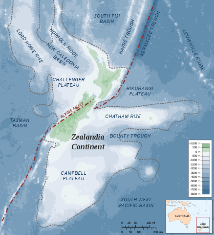
| Description | Map of the Zealandia (continent) |
| Date | |
| Source |
Own work
Bathymetry: ETOPO2v2 2min - edited with Inkscape , Land Information New Zealand , Te Ara The Encyclopedia of New Zealand |
| Author | Alexrk |
|
Permission
( Reusing this file ) |
Creative Commons : share alike - attribution required |
| Other versions |
 (topographic)
|


|
This SVG file contains embedded text that can be translated into your language, using any capable SVG editor, text editor or the SVG Translate tool . For more information see: About translating SVG files . |
Licensing
I, the copyright holder of this work, hereby publish it under the following license:
This file is licensed under the
Creative Commons
Attribution-Share Alike 3.0 Unported
license.
-
You are free:
- to share – to copy, distribute and transmit the work
- to remix – to adapt the work
-
Under the following conditions:
- attribution – You must give appropriate credit, provide a link to the license, and indicate if changes were made. You may do so in any reasonable manner, but not in any way that suggests the licensor endorses you or your use.
- share alike – If you remix, transform, or build upon the material, you must distribute your contributions under the same or compatible license as the original.