Şahdağ_Mountain,_Qusar,_2013.JPG

Size of this preview:
800 × 533 pixels
.
Other resolutions:
320 × 213 pixels
|
640 × 427 pixels
|
1,024 × 683 pixels
|
1,280 × 853 pixels
|
2,560 × 1,707 pixels
|
3,264 × 2,176 pixels
.
Summary
| Description |
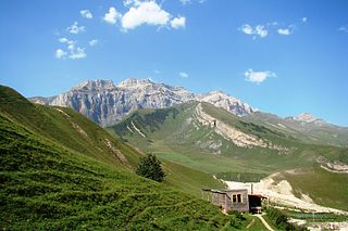
Azərbaycanca:
Şahdağın 2013-cü ilin yayında görunüşü
English:
The view of Mount Shahdag situated in the north of Azerbaijan in 2013
Русский:
Вид горы Шахдаг, расположенной на севере Азербайджана в 2013 году
|
| Date | |
| Source | Own work |
| Author | Murad Ahmadzade |
| Camera location |
|
View this and other nearby images on: OpenStreetMap |
|
|---|
Licensing
I, the copyright holder of this work, hereby publish it under the following license:
This file is licensed under the
Creative Commons
Attribution-Share Alike 3.0 Unported
license.
-
You are free:
- to share – to copy, distribute and transmit the work
- to remix – to adapt the work
-
Under the following conditions:
- attribution – You must give appropriate credit, provide a link to the license, and indicate if changes were made. You may do so in any reasonable manner, but not in any way that suggests the licensor endorses you or your use.
- share alike – If you remix, transform, or build upon the material, you must distribute your contributions under the same or compatible license as the original.
|
|
This image was uploaded as part of
Wiki Loves Earth 2014
.
|

|

|
This image won the 1
st
prize in the national contest of
Azerbaijan
in
Wiki Loves Earth 2014
Other languages:
|