Gulf_Fall_and_Uplands

Gulf Fall and Uplands

Gulf Fall and Uplands

Region in Australia


The Gulf Fall and Uplands, an interim Australian bioregion, is located in the Northern Territory and Queensland,[1][2] comprising 11,847,909 hectares (29,276,820 acres).[3]

Quick Facts Gulf Fall and Uplands Australia, Area ...

Described in IBRA5.1[1] as "undulating terrain with scattered low, steep hills on Proterozoic and Palaeozoic sedimentary rocks, often overlain by lateritised Tertiary material; skeletal soils and shallow sands; Darwin box (Eucalyptus tectifica) and variable-barked bloodwood (Corymbia erythrophloia) woodland to low open woodland with spinifex understorey."

The abbreviation for the bioregion is GFU.[3]
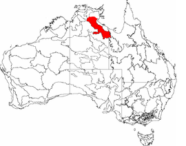
More information IBRA regions and subregions: IBRA7, IBRA region / subregion ...

See also


References

  1. Environment Australia. "Revision of the Interim Biogeographic Regionalisation for Australia (IBRA) and Development of Version 5.1 - Summary Report". Department of the Environment and Water Resources, Australian Government. Archived from the original on 5 September 2006. Retrieved 31 January 2007.
  2. "Interim Biogeographic Regionalisation for Australia (IBRA7) regions and codes". Department of Sustainability, Environment, Water, Population and Communities. Commonwealth of Australia. 2012. Retrieved 13 January 2013.

Further reading

  • Thackway, R and I D Cresswell (1995) An interim biogeographic regionalisation for Australia : a framework for setting priorities in the National Reserves System Cooperative Program Version 4.0 Canberra : Australian Nature Conservation Agency, Reserve Systems Unit, 1995. ISBN 0-642-21371-2


Share this article:

This article uses material from the Wikipedia article Gulf_Fall_and_Uplands, and is written by contributors. Text is available under a CC BY-SA 4.0 International License; additional terms may apply. Images, videos and audio are available under their respective licenses.