Highway_401
Ontario Highway 401
Controlled-access highway in Ontario
King's Highway 401, commonly referred to as Highway 401 and also known by its official name as the Macdonald–Cartier Freeway or colloquially referred to as the four-oh-one,[3] is a controlled-access 400-series highway in the Canadian province of Ontario. It stretches 828 kilometres (514 mi) from Windsor in the west to the Ontario–Quebec border in the east. The part of Highway 401 that passes through Toronto is North America's busiest highway,[4][5] and one of the widest.[6][7] Together with Quebec Autoroute 20, it forms the road transportation backbone of the Quebec City–Windsor Corridor, along which over half of Canada's population resides. It is also a Core Route in the National Highway System of Canada. The route is maintained by the Ministry of Transportation of Ontario (MTO) and patrolled by the Ontario Provincial Police. The speed limit is 100 km/h (62 mph) throughout its length, with the only exceptions the posted 80 km/h (50 mph) limit westbound in Windsor and in most construction zones, along with a 110 km/h (68 mph) speed limit between Windsor and Tilbury.[8]
| Macdonald–Cartier Freeway | ||||
Highway 401 highlighted in red | ||||
| Route information | ||||
| Maintained by the Ministry of Transportation of Ontario | ||||
| Length | 828.0 km[1] (514.5 mi) | |||
| History |
| |||
| Major junctions | ||||
| West end | Ojibway Parkway in Windsor | |||
| Major intersections |
| |||
| East end | ||||
| Location | ||||
| Country | Canada | |||
| Province | Ontario | |||
| Major cities | Windsor, London, Kitchener, Cambridge, Mississauga, Toronto, Oshawa, Kingston and Cornwall | |||
| Highway system | ||||
| ||||
By the end of 1952, three individual highways were numbered "Highway 401": the partially completed Toronto Bypass between Weston Road and Highway 11 (Yonge Street); Highway 2A between West Hill and Newcastle; and the Scenic Highway between Gananoque and Brockville, now known as the Thousand Islands Parkway. These three sections of highway were 11.8, 54.7, and 41.2 km (7.3, 34.0, and 25.6 mi), respectively. In 1964, the route became fully navigable from Windsor to the Ontario–Quebec border. In 1965 it was given a second designation, the Macdonald–Cartier Freeway, in honour of two Fathers of Confederation. At the end of 1968, the Gananoque–Brockville section was bypassed and the final intersection grade-separated near Kingston, making Highway 401 a freeway for its entire 817.9 km (508.2 mi) length. Since 2007, a portion of the highway between Trenton and Toronto has been designated the Highway of Heroes, as the route is travelled by funeral convoys for fallen Canadian Forces personnel from CFB Trenton to the coroner's office.
Highway 401 previously ended at Highway 3 (Talbot Road) upon entering Windsor. In 2011, construction began on a westward extension called the Rt. Hon. Herb Gray Parkway (formerly Windsor-Essex Parkway). This extension runs parallel to Highway 3 (Talbot Road and Huron Church Road) between the former end of the freeway and the E. C. Row Expressway, at which point the extension turns and runs alongside the E.C. Row towards the future Gordie Howe International Bridge. An 8-kilometre (5.0 mi) section of the parkway, east of the E. C. Row interchange, opened on June 28, 2015, with the remaining section completed and opened on November 21. The widening of the highway between Highway/Regional Road 8 in Kitchener to Townline Road in Cambridge to at least ten lanes was completed by December 22, 2023. There are plans underway to widen the remaining four-lane sections between Windsor and London to six lanes and to widen the route between Cambridge and Milton as well as through Oshawa. The expansive twelve-plus-lane collector–express system through Toronto and Pickering, and partially across Mississauga, was extended west to Milton in December 2022.

Highway 401 extends across Southwestern, Central and Eastern Ontario. In anticipation of the future expansion of the highway, the transportation ministry purchased a 91.4-metre-wide (300 ft) right-of-way along the entire length. Generally, the highway occupies only a portion of this allotment.[9] It is one of the world's busiest highways;[6] a 2019 analysis stated the annual average daily traffic (AADT) count between Renforth Drive and Highway 427 in Toronto was at 450,300,[1] while a second study estimates that over 500,000 vehicles travel that section on some days.[5] This makes it North America's busiest roadway, surpassing the Santa Monica Freeway in Los Angeles and I-75 in Atlanta.[7][10] The just-in-time auto parts delivery systems of the highly integrated automotive industry of Michigan and Ontario have contributed to the highway's status as the world's busiest truck route,[11] carrying 60 percent of vehicular trade between Canada and the US.[7]
Highway 401 also features North America's busiest multi-structure bridge at Hogg's Hollow in Toronto.[11] The four bridges, two for each direction with the collector and express lanes, carried an average of 360,300 vehicles daily in 2019.[1] The highway is one of the major backbones of a network in the Great Lakes region, connecting the populous Quebec City–Windsor corridor with Michigan, New York and central Ontario's cottage country.[12] It is the principal connection between Toronto and Montreal, becoming Autoroute 20 at the Ontario–Quebec border.[13]
Southwestern Ontario
Highway 401 does not yet extend across the Detroit River into Detroit.[14] By September 2025, the Gordie Howe International Bridge will extend Highway 401 across the Canada–United States border to a connection through Delray to Interstate 75 in Michigan.[15] At present, Highway 401 begins as a six-lane freeway in Brighton Beach (at the Canada–US border in Windsor) at the west end of the E. C. Row Expressway, sandwiched between the E. C. Row's opposing carriageways for a short distance. Highway 401 then changes to a southeast direction as it descends into a trench and runs alongside Highway 3 (Huron Church Road and Talbot Road). This below-grade section of the highway has 11 tunnels to cross underneath surface streets (including those carrying the Highway 3 routing). After passing under Howard Avenue and the ramps to Talbot Road, the highway then curves northeast and ascends back to the surface. At the split with Dougall Parkway (former Highway 3B) which links to the Detroit–Windsor tunnel, the highway turns east and exits Windsor.[16] From here, Highway 401 mostly parallels the former route of Highway 98 from Windsor to Tilbury.[17]

Southwestern Ontario is flat, primarily agricultural land, that takes advantage of the fertile clay soil deposited throughout the region.[18][19] The main river through the region is the Thames River, which drains the second largest watershed in southern Ontario and largely influences the land use surrounding the highway.[20] It parallels the route to the north between Tilbury and Woodstock.[16]
Near Tilbury, Highway 401 loses its tall wall median barrier and narrows to four lanes, following lot lines laid between concession roads in a plan designed to limit damage to the sensitive agricultural lands through which the highway runs.[21] Here the highway's flat and straight route is notorious for leading to driver inattention.[22] The section from Windsor to London (especially west of Tilbury) has become known for deadly car accidents and pile-ups, earning it the nickname Carnage Alley.[23] As the highway approaches London, Highway 402 merges in,[16] resulting in a six-lane cross-section.[24][25] Within London, it intersects the city's two municipal expressways, Highbury Avenue and the Veterans Memorial Parkway.[26]
The section between London and Woodstock generally parallels the former Highway 2 but lies on the south side of the Thames River.[16] This area is not as flat but the highway is generally straight. This part of Highway 401 often experiences heavy snowsqualls in early winter, sometimes extending as far east as Toronto. To the south of Woodstock, Highway 401 curves northeast as Highway 403 splits off.[26] The freeway then meets the former Highway 2 at an interchange, reconfigured from a cloverleaf to a five-ramp parclo in the late 2000s, near the Toyota West Plant. From here the highway heads towards Kitchener and Cambridge, substantially north of the route of the former Highway 2 which has been bypassed by Highway 403's western leg.
Heading towards Kitchener, the highway ascends as it crosses the Grand River followed by interchanges with King Street (Waterloo Regional Road 8) and Highway 8 before returning to its eastward orientation.[16][27] Between Highway/Regional Road 8 and Highway/Regional Road 24 in Cambridge, the highway was widened in 2020 to twelve lanes to accommodate the growing traffic using that segment.[28][29][30] Beyond Highway/Regional Road 24, the highway returns to a six-lane cross section and meanders towards Milton, passing through hills and rock cuts along the way.[31]

Greater Toronto Area
As Highway 401 approaches the Greater Toronto Area (GTA), it rounds Rattlesnake Point, part of the ecologically protected Niagara Escarpment, to the west of Milton.[32][33] Upon entering the town, it enters the first urbanized section of the GTA, passing through two rural areas between there and Oshawa.[16][34] Part of this rural gap is the western side of Toronto's Greenbelt, a zone around Toronto protected from development.[32] After this 10 km (6.2 mi) gap, the highway interchanges with the Highway 407 Express Toll Route. Within the GTA, the highway passes several major shopping malls including Toronto Premium Outlets, Yorkdale Shopping Centre, Scarborough Town Centre and Pickering Town Centre.[35][36][37]
.jpg)
Highway 401 widens into a collector-express system[38] (the first of three distinct sets) as it approaches James Snow Parkway in Milton, a concept inspired by the Dan Ryan Expressway in Chicago.[9] The system divides each direction of travel into collector and express lanes,[39] giving the highway a wide span and four carriageways. To avoid confusion between carriageways, blue signs are used for the collector lanes and green signs for the express lanes. Unlike the collector lanes, which provide access to every interchange, the express lanes only provide direct access to a select few interchanges. Access between the two is provided by transfers, which are strategically placed to prevent disruptions caused by closely spaced interchanges.[40] The overall purpose of the collector-express system is to maximize traffic flow for both local and long-distance traffic. In addition, Highway 401 was equipped with a traffic camera system called COMPASS in early 1991.[41] Using closed-circuit television cameras, vehicle detection loops and LED changeable-message signs, COMPASS enables the MTO Traffic Operations Centre to obtain a real-time assessment of traffic conditions and alert drivers of collisions, congestion and construction.[42] The system stretches from the Highway 403 / 410 interchange in Mississauga to Harwood Avenue in Ajax.[43]

The first collector-express section through the GTA is 4.6 km (2.9 mi) long and runs from James Snow Parkway to Highway 407. Beyond Highway 407, the freeway briefly narrows to 10 lanes east to Winston Churchill Boulevard, where the second section begins and runs 16.7 km (10.4 mi) to Highway 427; initially terminating just west of Highway 410 in the early 1990s, but extended westward in stages during the 2010s to include the interchanges with Hurontario Street, Mavis Road, and Mississauga Road; with the final extension to Winston Churchill being completed in 2022.[44] This system was originally designed to accommodate and organize various traffic movements from the Highway 403 / 410 and Highway 427 interchanges along Highway 401, replacing an earlier plan that would have run Highway 403 directly to Eglinton Avenue and the never-built Richview Expressway.[45] As the highway enters Toronto proper at the interchange with Renforth Drive, the collector lanes diverge to become the ramps to and from Highway 427 northbound and southbound. The third, and longest, at 43.7 km (27.2 mi), system starts from Highway 409 and continues through the city, ending at Brock Road in Pickering to the east.[46] The 5 km (3.1 mi) gap between the second and third systems is a traffic bottleneck since only a maximum of eight lanes (widened from originally six lanes) can pass through the interchange with Highway 427, due to the space constraints of the existing flyovers at this junction.[10]

Highway 401 widens to 18 lanes south of Toronto Pearson International Airport.[7] Progressing eastward, eight lanes are carried beneath the large spaghetti junction at Highway 427. The highway curves northeast and follows a power transmission corridor to Highway 409, which merges with the mainline and forms the collector lanes. It returns to its eastward route through Toronto, now carrying 12–16 lanes of traffic on four carriageways.[38] Highway 401 is often congested in this section, with an average of 442,900 vehicles passing between Weston Road and Highway 400 per day as of 2008.[1][7] In spite of this congestion, it is the primary commuting route in Toronto; over 50 percent of vehicles bound for downtown Toronto use the highway.[47] East of Highway 400 is The Basketweave, as each direction has a criss-crossing transfer between the express and collectors carriageways.[38] Near Yorkdale Shopping Centre, twelve lanes pass beneath a complicated interchange with Allen Road (formerly known as the Spadina Expressway). Further east, the highway crosses Hogg's Hollow over the West Don River on what is the busiest multi-span bridge crossing in North America, surpassing the Brooklyn Bridge, followed immediately by an interchange with Yonge Street which is also the centre of Toronto. Eastward the highway descends as it crosses Oriole GO Station, Leslie Street, and the East Don River in succession. It then climbs toward an interchange with the Don Valley Parkway and Highway 404, which provides access to downtown Toronto and the suburbs to the north, respectively.


Between Birchmount Road and Midland Avenue, the freeway is elevated on a berm as it crosses three surface streets and two railway lines. Progressing eastward in Scarborough, the Highway 401 continues through mostly residential areas and Scarborough City Centre including the shopping mall. The highway eventually reaching the city's eastern edge where at Meadowvale Road it turns southeast briefly before it swings northeast as Highway 2A (downloaded from the province to the municipality in 1998) merges into it, followed immediately by an interchange with Kingston Road and Port Union Road/Sheppard Avenue, then crossing the Rouge Valley into Pickering.[38]
West of Pickering, Highway 401 again meets former Highway 2, which thereafter parallels it to the Ontario–Quebec border.[16] As the highway approaches Brock Road in Pickering, the collector and express lanes converge, narrowing the 14-lane cross-section to 10, divided only at the centre.[48] It remains this width as it passes into Ajax,[38] before narrowing to six lanes at Salem Road.[49] Planned expansions east of Salem to improve flow leading into the Highway 412 and Lakeridge Road interchanges will see the highway widened to ten lanes as far as Brock Street in Whitby, where the existing interchange will be reconfigured.[50]
East of Ajax, the highway passes through the second 3.5 km (2.1 mi) rural gap, and enters Whitby. The stretch of Highway 401 through Whitby and Oshawa features several structures completed during the initial construction of the highway in the 1940s.[10] Several of these structures are to be demolished, either due to their age, or to prepare for the planned widening of Highway 401 through this area.[51] A former Canadian National Railway overpass, which was fenced off but commonly used by pedestrians during Highway of Heroes repatriations, was demolished on the night of June 11, 2011. A second structure in Bowmanville was demolished during two overnight closures on July 9 and 16.[52] At Harmony Road, the suburban surroundings quickly transition to agricultural land. The highway curves around the south side of Bowmanville and travels towards Highway 35 and Highway 115.[34]
 Highway 401 looking east between Avenue Road and Yonge Street; the North York skyline is visible in the distance
 Highway 401 at the interchange with Highway 410 and Highway 403 in Mississauga
 Traffic cameras are mounted at every exit within Toronto and form one part of the COMPASS system.
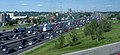 The collector-express system just east of the Highway 400 interchange, with the "Basketweave" transfers between them in the background.
 Express to collector transfer
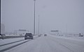 Winter conditions on Highway 401 in Toronto due to a snowsquall.
 Newly opened in 2022, collector-express system in Mississauga viewed from the pedestrian bridge that replaced the original road bridge carrying Second Line West
 Highway 401 west of the Don Valley Parkway at dusk


Eastern Ontario

From east of Highway 35 and Highway 115 to Cobourg, Highway 401 passes through a mix of agricultural land and forests, maintaining a straight course.[53] Highway 401 passes through the north end of the towns of Port Hope and Cobourg with two interchanges each. Just east of Cobourg, the highway narrows to four lanes and the terrain becomes undulating, with the highway routed around hills and through valleys along the shores of Lake Ontario.[54] At Trenton, the highway crosses the Trent Canal and returns to an agricultural setting. It then crosses the Moira River as it goes through Belleville before heading eastward to Kingston.[13] The Kingston portion of the highway, originally named the Kingston-Bypass, was one of the first sections of the highway to be completed;[2] it is now mostly three lanes each way.[55]

East of Kingston, the highway continues through a predominantly agricultural area alongside the St. Lawrence River to Gananoque, where it splits with the Thousand Islands Parkway,[56] one of the original sections of the highway designated in 1952.[57] The highway runs parallel to the parkway several kilometres inland from the river. The Canadian Shield, an ancient geological formation, appears through this heavily forested section of the highway. Highway 401 rejoins the Thousand Islands Parkway immediately southwest of Brockville, now heading northeast.[58]
The remainder of the highway runs parallel to the former Highway 2 along the shore of the St. Lawrence River within the St. Lawrence Valley. Northeast of Brockville is the interchange with Highway 416, which heads north to Ottawa.[59] At the Ontario–Quebec border, Highway 401 becomes Autoroute 20 and continues to Montreal.[60]
Traffic volume
The MTO publishes yearly traffic volume data for provincial highways, expressed as an average daily vehicle count over the span of a year (AADT).[1] The table below compares the AADT at several locations along Highway 401 using data from 1969, 1988, 2008 and 2016.
| Location | Section | Traffic volume (AADT) | |||
|---|---|---|---|---|---|
| 1969[61] | 1988[1] | 2008[1] | 2016[1] | ||
| Windsor | Dougall Parkway – Essex County Road 46 | 9,550 | 13,200 | 16,700 | 17,500 |
| London | Highbury Avenue – Veterans Memorial Parkway | 17,450 | 33,800 | 64,500 | 64,200 |
| Woodstock | Oxford County Road 59 – Highway 403 | 16,700 | 35,100 | 67,100 | 67,500 |
| Cambridge | Highway 8 – Highway 24 | 19,900 | 50,400 | 125,600 | 137,300 |
| Mississauga | Mississauga Road – Hurontario Street | 28,450 | 97,100 | 177,300 | 216,500 |
| Toronto | Weston Road – Highway 400 | 106,850 | 319,600 | 442,900 | 416,500 |
| Oshawa | Stevenson Road – Simcoe Street | 29,000 | 79,000 | 120,700 | 134,200 |
| Belleville | Highway 62 – Highway 37 | 13,750 | 22,500 | 43,500 | 45,300 |
| Kingston | Frontenac County Road 38 – Sydenham Road | 12,000 | 20,700 | 45,400 | 55,000 |
| Brockville | Highway 29 – North Augusta Road | 10,050 | 15,300 | 29,100 | 33,600 |
| Cornwall | Highway 138 – McConnell Avenue | 10,300 | 12,900 | 18,400 | 21,400 |
| Location | Lane count | Distance |
|---|---|---|
| E C Row Expressway to Essex County Road 42 | 6 lanes | 55.7 km (34.6 mi) |
| Essex County Road 42 to Highway 402 | 4 lanes | 127.5 km (79.2 mi) |
| Highway 402 to Highway 8 | 6 lanes | 94.6 km (58.8 mi) |
| Highway 8 to Highway 24 (Hespeler Road) | 12 lanes | 3.0 km (1.9 mi) |
| Highway 24 (Hespeler Road) to Townline Road | 10 lanes | 3.8 km (2.3 mi) |
| Townline Road to Halton Regional Road 25 | 6 lanes | 33.3 km (20.7 mi) |
| Halton Regional Road 25 to James Snow Parkway | 10 lanes | 4.3 km (2.7 mi) |
| James Snow Parkway to Highway 407 | 12-lane collector-express system | 5.3 km (3.5 mi) |
| Highway 407 to Winston Churchill Boulevard | 10 lanes | 3.3 km (2.0 mi) |
| Winston Churchill Boulevard to Highway 403 / 410 | 12-lane collector-express system | 10.5 km (3.5 mi) |
| Highway 403 / 410 to Highway 427 | 18-lane collector-express system | 5.8 km (3.6 mi) |
| Highway 427 to Highway 27 | 8 lanes | 0.8 km (0.50 mi) |
| Highway 27 to Highway 409 | 10 lanes | 3.9 km (2.4 mi) |
| Highway 409 to Brock Road | 12–16-lane collector-express system | 43.3 km (26.9 mi) |
| Brock Road to Salem Road | 10 lanes | 6.0 km (3.7 mi) |
| Salem Road to 4.5 km east of Baltimore Road | 6 lanes | 74.8 km (46.5 mi) |
| 4.5 km east of Baltimore Road to Frontenac County Road 38 | 4 lanes | 131.7 km (81.8 mi) |
| Frontenac County Road 38 to Highway 15 | 6 lanes | 12.2 km (7.6 mi) |
| Highway 15 to ON–QC border | 4 lanes | 205.0 km (127.4 mi) |
Predecessors
Highway 401's history predates its designation by over two decades. As automobile use in southern Ontario grew in the early 20th century, road design and construction advanced significantly. Following frequent erosion of Lake Shore Road, then macadamized,[62] a concrete road known as the Toronto–Hamilton Highway was proposed in January 1914. Construction began on November 8 of that year, following the onset of World War I.[63][64] The highway was designed to run along the lake shore, instead of Dundas Street to the north, because the numerous hills encountered along Dundas would have increased costs without improving accessibility. Middle Road, a dirt lane named because of its position between the two, was not considered since Lake Shore and Dundas were both overcrowded and in need of serious repairs.[65] The road was formally opened on November 24, 1917,[62][63] 5.5 m (18 ft) wide and nearly 64 km (40 mi) long. It was the first concrete road in Ontario, as well as one of the longest stretches of concrete road between two cities in the world.[66]
Over the next decade, vehicle usage increased substantially, and by 1920, Lakeshore Road was again congested, particularly during weekends.[67] In response, the Department of Highways examined improving another road between Toronto and Hamilton. The road was to be more than twice the width of Lakeshore Road at 12 m (39 ft) and would carry two lanes of traffic in either direction.[68] Construction on what was then known as the Queen Street Extension west of Toronto began in early 1931.[69]
Before the highway could be completed, Thomas McQuesten was appointed the new minister of the Department of Highways, with Robert Melville Smith as deputy minister, following the 1934 provincial elections.[10] Smith, inspired by the German autobahns—new "dual-lane divided highways"—modified the design for Ontario roads,[70] and McQuesten ordered the Middle Road be converted into this new form of highway.[71][72][73] A 40 m (130 ft) right-of-way was purchased along the Middle Road and construction began to convert the existing sections to a divided highway. Work also began on Canada's first interchange at Highway 10.[68]
Beginning in 1935, McQuesten applied the concept of a dual-highway to several projects along Highway 2, including along Kingston Road in Scarborough Township.[10][74] When widening in Scarborough reached the Highland Creek ravine in 1936, the Department of Highways began construction on a new bridge over the large valley, bypassing the former alignment around West Hill.[75] From here the highway was constructed on a new alignment to Oshawa, avoiding construction on the congested Highway 2.[9] As grading and bridge construction neared completion on the new highway between West Hill and Oshawa in September 1939, World War II broke out and gradually tax revenues were re-allocated from highway construction to the war effort.[10] At the same time, between September 6 and 8, 1939, the Ontario Good Roads Association Conference was held at Bigwin Inn, near Huntsville,[76] drawing highway engineers from across North America to discuss the new concept of "Dual Highways." On the first day of the convention, McQuesten announced his vision of the freeway: an uninterrupted drive through the scenic regions of Ontario, discouraging local business and local traffic from accessing the highway except at infrequent controlled-access points.[77] It was announced in the days thereafter this concept would be applied to a new "trans-provincial expressway", running from Windsor to the Ontario–Quebec border.[78]
Highway engineers evaluated factors such as grading, curve radius, and the narrow median used along the Middle Road—which was inaugurated on August 23, 1940, as the Queen Elizabeth Way (QEW)[79]—and began to plan the course of a new dual highway mostly parallel to Highway 2, with precedence given to areas most hampered by congestion. Unlike the QEW, this highway would not be built along an existing road, but rather on a new right-of-way, avoiding the need to provide access to properties.[10][77] Along with immense improvements to machinery and construction techniques over its six-year course, the war provided planners an opportunity to conduct a survey of 375,000 drivers, asking them about their preferred route to travel to their destination. Using this information, a course was plotted from Windsor to Quebec, bypassing all towns along the way.[9][80]
Highway 2S (S for Scenic) was the first completed section of new roadway. Built to connect with the Thousand Islands Bridge at Ivy Lea and opened as a gravel road in late 1941 or early 1942,[81] the road followed the shore of the Saint Lawrence River and connected with the western end of the twinned Highway 2 near Brockville.[16] In addition, the highway between Highland Creek and Oshawa was opened as a gravel-surfaced road in May 1942.[82]
Following the war, construction resumed on roadways throughout Ontario. The expressway between Highland Creek and Oshawa was completed in December 1947 and designated as Highway 2A,[9] while other sections languished. The Toronto–Barrie Highway was the primary focus of the Department of Highways at the time, and the onset of the Korean War in 1950 stalled construction again. Despite the delays, highway minister George Doucett officially announced the plans for construction of the new trans-provincial expressway that year, with the Toronto to Oshawa expressway serving as a model for the design.[10] Work on the most important link, the Toronto Bypass, began in 1951,[10] but it would not open with that name.
Assumption
In July 1952 (possibly July 1, the same day Highway 400 was numbered),[lower-alpha 1][57] the Highland Creek to Oshawa expressway (Highway 2A) and Highway 2S were designated Controlled-Access Highway No 401,[9] a move scorned by one critic because of the lack of thought given to the numbered name.[83] Construction was completed for several sections of the Toronto Bypass: between Highway 400 and Dufferin Street in August, west to Weston Road in September, east to Bathurst Street in October and finally to Yonge Street in December.[2] A 3.4 km (2.1 mile) stub of Highway 2A which was not incorporated into Highway 401 remained a provincial route as a connector to Kingston Road.
Extensions east and west began in 1953; the eastern extension to Bayview Avenue opened in April 1955,[2] but the western extension was delayed by the damage caused by Hurricane Hazel on October 15, 1954, which nearly destroyed the new bridge over the Humber River. The reconstruction would take until July 8, 1955,[84] and the highway was opened between Weston and Highway 27 in September 1955.[2]
The entire bypass, including the widening of Highway 27 into an expressway south of Highway 401,[9][85] was completed in August 1956.[2][9] Upon its opening, the bypass was described by one reporter as "a motorist's dream" providing "some of the most soothing scenery in the Metropolitan area". The reporter continued, with regard to the eastern section through Scarborough, that it "winds smoothly through pastures across streams and rivers, and beside green thickets. It seems a long way from the big city."[9] By 1959 however, the bypass was a lineup of cars, as 85,000 drivers crowded the roadway, designed to handle a maximum of 48,000 vehicles, on a daily basis.[9] Motorists found the new road to be a convenient way of travelling across Toronto; this convenience helped influence the suburban shift in the city and continues to be a driving force of urban sprawl today.[57]
Meanwhile, beyond Toronto, the highway was being built in a patchwork fashion, focusing on congested areas first.[10] Construction west from Highway 27 began in late 1954,[86] as did the Kingston Bypass in Eastern Ontario.[87] Work began to connect the latter with the Scenic Highway in 1955.[86] After the 1954 New York State Thruway opened from Buffalo to New York City,[88] Michigan officials encouraged Ontario to bypass Highway 3 as the most direct path from Detroit to Buffalo.[89] By 1956, construction had begun on a segment between Highway 4 in London and Highway 2 in Woodstock, as well as on the section between Windsor and Tilbury.[90]
In 1958, a section bypassing Morrisburg was opened to accommodate traffic displaced from a portion of Highway 2 through The Lost Villages of the Saint Lawrence Seaway.[91]
By the end of 1960, the Toronto section of the highway was extended both eastwards and westwards: first east from Newcastle to Port Hope on June 30; then later west from Highway 25 in Milton to Highway 8 south of Kitchener on November 17.[2] By mid-1961, the section between Brighton and Marysville had opened.[92] The gap to the east, from Highway 28 in Port Hope to Highway 30 in Brighton was opened on July 20 of that year.[93]
The gap between Woodstock and Kitchener was completed on November 9, 1961, while the gap between Tilbury and London was completed two lanes at a time; the westbound lanes on October 22, 1963, the eastbound on July 20, 1965.[2] The gap between Marysville and Kingston was opened by 1962.[92] The final sections, from west of Cornwall to Lancaster, were opened between 1962 and 1964;[92][94] two lanes opened to Lancaster on September 11, 1962, but the other two were not completed until July 31, 1964. The last segment, to the Ontario–Quebec border, was opened on November 10, 1964.[2]
As originally envisioned by McQuesten, Highway 401 had been routed along the Thousand Islands Parkway since 1952.[95] However, by then numerous properties and a tourist industry were established, which had not been present when the parkway originally opened in 1938. James Auld, MPP for Leeds and the Minister of Tourism and Information, joined local residents to persuade the DHO to construct an inland bypass.[10][96] The DHO agreed, stating that it would cost less to build a new freeway than to upgrade the parkway.[97] Construction of the Thousand Islands Bypass began in 1965, with work proceeding east from Gananoque. The Thousand Islands Parkway was the final two-lane segment of Highway 401.[98] A portion was opened on September 1, 1967, from Gananoque to Highway 137, which was itself built south to the parkway at the same time.[99] The Highway 401 designation was applied along this new route, while the bypassed portion of the parkway was redesignated as Highway 2S.[100] Despite the expected influx of traffic from the United States for Expo 67 in Montreal, the DHO opted to build the portion east of Ivy Lea after the centennial celebrations.[101] The remainder of the bypass was opened to traffic on October 11, 1968 Finally, on October 11, 1968, the Thousand Islands Bypass opened.[9] This final piece was commemorated with a plaque to signify the completion of Highway 401.[10]
Expansion
In Toronto, engineers and surveyors were examining the four-lane bypass, while planners set about designing a way to handle the commuter highway. In 1963, transportation minister Charles MacNaughton announced the widening of Highway 401 in Toronto from four to a minimum of 12 lanes between Islington Avenue and Markham Road. The design was taken from the Dan Ryan Expressway in Chicago, which was widened into a similar configuration around the same time.[9] Construction began immediately. While the plan initially called for construction to end in 1967, it continued for nearly a decade. At least four lanes were always open during the large reconstruction project, which included complex new interchanges at Highway 27, Highway 400, the planned Spadina Expressway and the Don Valley Parkway. The system was completed in 1972, along with the Highway 27 (renamed Highway 427) bypass between the QEW and Pearson Airport. Most of the interchanges in Toronto were reconstructed as partial cloverleafs and a continuous lighting system was installed.[10]
On January 11, 1965, at the dinner celebration of Sir John A. Macdonald's 150th birthday, the Premier of Ontario John Robarts designated Highway 401 the Macdonald–Cartier Freeway to honour Macdonald and George-Étienne Cartier, two of Canada's Fathers of Confederation.[102][103] Unlike other names later applied to the highway, the Macdonald–Cartier Freeway designation covers the entire length of Highway 401. Signs designating the freeway and shields with the letters 'M-C' were installed, but these had been removed by 1997.[104] In 2003, 38 years after Robarts' naming of the highway, a Member of Provincial Parliament attempted to get the Macdonald-Cartier Freeway highway name enshrined into law; the bill only passed first reading and was not enacted.[105]
In the 1970s, Highway 401 was widened to six lanes in Durham. Between 1977 and 1982, Highway 401 was widened from four to six lanes between Hurontario Street (Highway 10) to Highway 25, with the Jersey median barrier making its debut in Ontario in that segment.[10]
Plans had been completely modified to connect the under-construction Mississauga leg of Highway 403 from QEW to Highway 401 at the new Highway 410 interchange.[106] For Highway 403, the Highway 410 interchange was a better connection point than the original suggested terminus at the Highway 401-427 interchange, but would also require the widening of Highway 401 from six lanes to twelve. Plans were submitted and approved in December 1977 by Mississauga city council, and construction began.[107] The first section of Highway 403 between Cawthra Road and Highway 401 was opened August 18, 1980; the original connecting ramps were built on the outer perimeter of the interchange to serve what would later be designated as the collector lanes of both routes, leaving sufficient right-of-way between for future ramps linking the express lanes of both routes.[108]
The 1980s saw more sections of Highway 401 widened. Most significant was the new collector-express system between Highway 403 / 410 and Highway 427, including a new set of flyover ramps from the express lanes to Highway 403 which opened in 1984, while a basketweave transfer between the eastbound collector and express lanes near Pearson Airport was completed in mid-1985. At this time, the Highway 401 express lanes merged into the collector lanes east of Tomken Road which resulted in a temporary left-handed exit/entry for the ramps to/from the Highway 403 express lanes.[109]
After the Kennedy Road overpass was replaced, cast-in-place concrete flyover ramps were constructed from 1988 to late 1990 to link up Highway 401 and Highway 410, notably the 11-span flyover ramp from Highway 401 eastbound to Highway 410 northbound which remains the longest in the Greater Toronto Area, while the Highway 410 southbound to Highway 401 eastbound flyover replaced a loop ramp. In the fall of 1991, alongside the widening of Highway 410 into a full freeway, construction began on the connecting ramps between Highway 403 and Highway 410, which pass under the existing bridge structures carrying Highway 401 (which would soon be designated as the collector lanes), while new overpasses were constructed for the Highway 401 express lanes which were extended from east of Tomken Road to just east of Kennedy Road.[110][111]
Plans were made to extend the eastern system from Neilson Road to Brock Road in Pickering in the late 1980s,[112] but took over a decade to reach fruition by 1997.[113][114][115] This was followed shortly thereafter by the widening of the highway through Ajax and a new interchange at Pickering Beach Road (renamed Salem Road) and Stevenson Road.[116]
The 1990s also saw the first step in widening the highway from Toronto to London, by replacing the grass median with the addition of a third traffic lane per direction separated by a tall-wall concrete median barrier. The segment from London to Woodstock received this upgrade first, with the expansion shortly east of the split for Highway 403's newly constructed western segment.[117] A project in the mid-1990s brought the highway up to a minimum of six lanes between Highway 8 in Kitchener and Highway 35 / 115 in Newcastle.[118] Other projects prepared sections for eventual widening.[119]
In its 2007 plan for southern Ontario, the MTO announced long-term plans to create high-occupancy vehicle (HOV) lanes from Mississauga Road west to Milton;[120] by 2011 these plans had been expanded in scope to as far west as Hespeler Road in Cambridge.[121]
From the mid-1990s onward, several prerequisite projects were undertaken for the future widening of Highway 401 throughout Milton and Mississauga, although that section of the freeway would retain its six-lane cross section for at least the next decade. This included the new interchange with the upcoming Highway 407 ETR (with a temporary diversion for the eastbound lanes to facilitate construction of the post-tensioned flyovers), a new underpass structure to accommodate Derry Road which was widened from two to six lanes (1996–97), the addition of an interchange with the Mavis Road extension in 1999 whose overpass was designed to be lengthened with two outer spans,[122] and replacing the Mississauga Road overpass which began on February 15, 2002 [123] (in a cost-sharing agreement between the province and Peel Region) and completed in 2003.[10] More recent work included the replacement of the McLaughlin Road overpass in 2008.[124][125]
Starting on August 19, 2009, Highway 401's collector-express lanes in Mississauga have been extended westward beyond its initial terminus at Highway 410.[122][124] The widening of this 7 km segment to the Credit River necessitated the replacement of several existing overpasses, including those of Hurontario Street (2013) and Second Line West (2016), with the Second Line West crossing rebuilt as a pedestrian/cyclist bridge since most vehicular traffic was already rerouted to the Mavis Road extension.[126][127] Tying into this extension of Highway 401's collector-express system, the missing ramps from Highway 401 eastbound to Highway 403 westbound and the opposite movement were completed in 2018[122] which also provided direct access to Cawthra Road, making the Highway 401-403-410 junction a full four-way interchange.[128] The first phase of this expansion to west of Hurontario Street, a distance of 2.8 km (1.7 mi), opened in 2013,[129] while the second phase to the Credit River was completed in 2020.[130]
In 2019, an announcement was made for expanding the freeway from the Credit River to Regional Road 25 in Milton to a minimum of 10 lanes, including HOV lanes. This project included extending the existing 12-lane collector–express system from the Credit River to just east of Winston Churchill Boulevard, while another 12-lane collector–express system was built from just west of the Highway 407 interchange to just east of James Snow Parkway, due to the overpasses for the 407 and the adjacent Winston Churchill Boulevard not being constructed wide enough to accommodate a continuous collector–express system underneath.[131]
Sections of the new expansion were opened overnight throughout the second half of 2022. On August 13 and 14, 2022, the westbound express lanes opened between Highway 407 and James Snow Parkway. The remainder of the westbound lanes, between the Credit River and Winston Churchill Boulevard, were opened several months later on November 13 and 14. The eastbound express lanes between James Snow Parkway and Winston Churchill Boulevard were opened a week later on November 18 and 19, and from Winston Churchill Boulevard to the Credit River on November 29 and 30. The HOV lanes in both directions were opened on December 9, 2022.[132][133] The remaining works of this project, including final layers of paving, culvert works, and carpool lots were completed on October 19, 2023, thus completing a 14-year project that expands the highway from Highway 410 to Regional Road 25 that started back on August 19, 2009.[134][135][non-primary source needed]
Advantage I-75
Between June 1990 and 1998, Highway 401 and Interstate 75 were used for a pilot project named Advantage I-75 to test the reliability and versatility of an automated tracking system for transport trucks. Termed "MACS" (Mainline Automated Clearance System), it allows a truck to travel from Florida to Ontario without a second inspection.[136] MACS was initially tested at two truck inspection stations in Kentucky, with transponders installed in 220 trucks. Exact time, date, location, weight and axle data were logged as a truck approached an equipped station.[137] Following initial tests, MACS was deployed at every inspection station along I-75 from Miami to Detroit, and along Highway 401 from Windsor to Belleville in 1994.[136] The project demonstrated the effectiveness of electronic systems in enforcing freight restrictions without delaying vehicles, while alleviating security fears such systems could be compromised. The concept has since been applied to many parts of Canada, including Highway 407's electronic tolling system.[138]
"Carnage Alley"
The section of Highway 401 between Windsor and London has often been referred to as Carnage Alley, in reference to the numerous crashes that have occurred throughout its history. The term became more commonplace following several deadly pileups during the 1990s.[10] The narrow and open grass median was an ineffective obstacle in preventing cross-median collisions. The soft shoulders consisted of gravel, with sharp slopes which were blamed for facilitating vehicle rollovers.[139] The nature of that section of highway, described as a mainly straight road with a featureless agricultural landscape, was said to make drivers feel less involved and lose focus on the road. In winter, the area between Woodstock and Chatham is also subject to sudden snow squalls from lake-effect snow.[140] Several collisions have resulted from motorists deviating from their lane and losing control of their vehicles.[139][141]
Various other names, including The Killer Highway circulated for a time,[142] but Carnage Alley became predominant following an 87-vehicle pile-up on September 3, 1999 (the start of Labour Day weekend), the worst in Canadian history, that resulted in eight deaths and 45 injured individuals.[143]
Only a few days prior, then-Transportation Minister David Turnbull had deemed the highway "pleasant" to drive.[144] On the morning of September 3, the local weather station reported clear conditions due to a malfunction,[143] while a thick layer of fog rolled onto the highway. Dozens of vehicles, including several semi-trailers, quickly crashed into each other shortly after 8 a.m., one following another in the dense fog, with collisions in both directions at that segment of Highway 401, although no vehicles crossed the highway's median.[145][146] Immediately following the crash, the MTO installed paved shoulders with rumble strips[147] and funded additional police to patrol the highway, a move criticized as being insufficient.[148]
Beginning in 2004, 46 km (29 mi) of the highway was widened from four asphalt lanes to six concrete lanes, paved shoulders were added, and a concrete Ontario Tall Wall median was installed,[149] which was the solution the Canadian Automobile Association promoted in 1999.[139] Interchanges were improved and signage was upgraded as part of a five-phase project to improve Highway 401 from Highway 3 in Windsor to Essex County Road 42 (formerly Highway 2) on the western edge of Tilbury.[24]
From 2008 to 2010, with joint funding from the provincial and federal governments, the section of Highway 401 from Dougall Parkway (former Highway 3B) to Provincial Road (former Highway 98) was widened to six lanes, necessitating the replacement of several underpasses including those of Walker Road and Provincial Road. As part of that project, the Dougall Parkway split with Highway 401 was reconfigured, replacing a one-lane 1950s-era underpass tunnel with a modern high-speed flyover ramp. The old interchange had reduced eastbound Highway 401 traffic to one lane as it merged with Dougall Parkway, whereas the new interchange allows three lanes per direction of Highway 401 to pass through. West of the reconstructed Dougall Parkway onramp, Highway 401's grass median was replaced with a concrete barrier but continued to be striped for two lanes per direction until the North Talbot Road overpass was replaced and Phase One of the Highway 401 extension (Rt. Hon. Herb Gray Parkway, formerly Windsor-Essex Parkway) (see below) opened in 2015, allowing for a continuous six lane freeway cross-section.[150]
Highway of Heroes
On August 24, 2007, the MTO announced the stretch of Highway 401 between Glen Miller Road in Trenton and the intersection of the Don Valley Parkway and Highway 404 in Toronto would bear the additional name Highway of Heroes (French: Autoroute des héros), in honour of Canadian soldiers who have died,[151] though Highway 401 in its entirety remains designated as the Macdonald–Cartier Freeway.[152] This length of the highway is often travelled by a convoy of vehicles carrying a fallen soldier's body, with his or her family, from CFB Trenton to the coroner's office at the Centre for Forensic Sciences in Toronto. Since 2002, when the first fallen Canadian soldiers were repatriated from Afghanistan, crowds have lined the overpasses to pay their respects as convoys pass.[153]
The origin of the name can be traced to an article in the Toronto Sun on June 23, 2007, by columnist Joe Warmington, in which he interviewed Northumberland photographer Pete Fisher. Cobourg resident Ron Flindall was responsible for organizing the first bridge salutes following the loss of four soldiers on April 18, 2002.[154][155]
Warmington described the gathering of crowds on overpasses to welcome fallen soldiers as a "highway of heroes phenomena".[156] This led a Cramahe Township volunteer firefighter to contact Fisher on July 10 about starting a petition, leading Fisher to publish an article which was posted to the Northumberland Today website.[157] The online article eventually caught the attention of London resident Jay Forbes. Forbes began a petition, which received over 20,000 signatures[151] before being brought to the Minister of Transportation on August 22.[158] Following the announcement on August 24, the provincial government and MTO set out to design new signs. The signs were erected and unveiled on September 7,[152] and include a smaller reassurance marker (shield), as well as a larger billboard version.[159]
On September 27, 2013, the Highway of Heroes designation was extended west to Keele Street in Toronto, to coincide with the move of the coroner's office to the new Forensic Services and Coroner's Complex located at Highway 401 and Keele Street.
Highway improvements and safety concerns
London and Kitchener
Between 2006 and 2008, Highway 401 was widened from four to six lanes between Highway 402 and Wellington Road in London. This included reconfiguring the Wellington Road interchange from a cloverleaf to a Parclo A4 while replacing the original 1956 overpass with a longer and wider structure.[24]
In November 2010, the widening of Highway 401 from four to six lanes between Woodstock and Kitchener was completed after many years of planning and construction.[160] The project included the installation of a tall-wall median barrier, straightening curves and adding additional interchanges on the freeway, allowing it to be easily vacated in an emergency event.[161]
Greater Toronto Area
Beginning in 1998, several projects were initiated on Highway 401 within Toronto. The freeway's pavement through the city was resurfaced. The most significant construction work was widening the route from six to eight lanes though the Highway 427 interchange in 2005, which necessitated the replacement of the Highway 27 underpass, although the rest of the junction's flyovers could accommodate the expansion.[6] Some projects have been completed during overnight construction projects, including the widening and rehabilitation of the Hogg's Hollow bridge,[162] the replacement of the original gantries throughout the collector-express system,[163] and rehabilitating the flyover ramps of the Highway 401 / 400 interchange.[164][165]
On August 10, 2008, following a series of explosions at a propane facility in Toronto, Highway 401 was closed between Highway 400 and Highway 404 as a precautionary measure, the largest closure of the highway in its history.[166] The highway remained closed until 8 p.m., though several exits near the blast remained closed thereafter.[167][168]
In Oshawa, exit 416 (Park Road) was replaced by a new interchange at exit 415 (Stevenson Road). The contract, which began September 7, 2005, included the interchange and the resurfacing of 23.4 km (14.5 mi) of the highway between Oshawa and Highway 35 / Highway 115.[169] The westbound ramps were opened in mid-September 2007[170] and the eastbound ramps in mid-2009. The resurfacing was completed mid-2010.[169]
In 2013, as a prerequisite to construction of the West Durham Link which was eventually numbered as Highway 412, the section of Highway 401 near the Lake Ridge Road overpass was shifted northward on a new alignment away from the parallel railway lines to allow sufficient right-of-way for the interchange to the new route. The existing Lake Ridge Road overpass was also replaced by a new longer structure that would span both the existing and new alignments of Highway 401 as well as the railways. Once the new alignment of Highway 401 was opened for both directions, the old Highway 401 right-of-way was used for the semi-directional onramp from Highway 401 eastbound to Highway 412 as well as an offramp to Lake Ridge Road.[171][172] The interchange to Highway 412 opened on June 20, 2016.[173]
Rt. Hon. Herb Gray Parkway
Highway 401 as originally completed did not have direct access to the Canada–United States border, as upon entering the Windsor city limits the route terminated at a split interchange with Highway 3 where the freeway defaulted into Talbot Road. Traffic continuing to the border had to follow the non-express Highway 3 routing along Talbot Road and Huron Church Road which had a dozen traffic lights. The approach to the Ambassador Bridge was heavily built up making it impractical to twin the existing crossing and reconstruct the approach as a freeway to meet growing demand for cross-border traffic, even though Ambassador Bridge owner Matty Moroun had long lobbied for this.[174][175][176]
In 2004, a joint announcement by the federal government of the United States and Government of Canada confirmed a new border crossing would be constructed between Detroit and Windsor. The Detroit River International Crossing (DRIC) was formed as a bi-national committee to manage the project.[174] The MTO took advantage of this opportunity to extend Highway 401 to the Canada–US border and began an environmental impact assessment on the entire project in late 2005.[174] The City of Windsor also hired New York traffic consultant Sam Schwartz to design a parkway to the border. Schwartz's proposal would eventually inspire the DRIC's own design, but his route was not chosen, with the DRIC opting instead to take a northern route.[177] On February 8, 2008, the MTO announced it had begun purchasing property south of the E. C. Row Expressway, upsetting many area residents who had purchased properties in the years prior.[178][179]
On March 3, 2008, the Michigan Department of Transportation and the MTO (in partnership with Transport Canada, the Federal Highway Administration of the United States and the Detroit River International Crossing group) completed a joint assessment on the soils along the Detroit River and determined they could indeed support the weight of a new bridge; the stability of the underlying soil and clay and the impact of the nearby Windsor Salt Mine had caused concern for all parties involved in the project.[180]
Despite protest from area residents,[181] as well as a dismissed lawsuit from Ambassador Bridge owner Matty Moroun,[175][176] it was announced on May 1, 2008, that a preferred route had been selected for the Highway 401 extension which would be named the Windsor–Essex Parkway.[182] On November 28, 2012, the Ministry of Transportation announced a Federal Order in Council was passed to change the name of the parkway to the "Rt. Hon. Herb Gray Parkway", in honour of the Right Honourable Herb Gray, a Member of Parliament from Windsor.[183]
The Highway 401 extension (Rt. Hon. Herb Gray Parkway, formerly Windsor-Essex Parkway, MTO internal designation of Highway 7901[1]) would first run parallel to the realigned Highway 3 (Talbot Road and Huron Church Road) from a new interchange at the former end of Highway 401 to the E. C. Row Expressway. The Highway 401 extension would then turn westward and continue between the opposing carriageways of the E. C. Row Expressway for 2 km (1.2 mi) (requiring that the E. C. Row's eastbound carriageway between Matchette Road and Huron Church Road be shifted so the median can accommodate the Highway 401 extension), with slip ramps linking the E. C. Row to the bridge-bound Highway 401. At the Ojibway Parkway, the Highway 401 extension would turn northwest and follows a new alignment to the border.[184] The Highway 401 extension would have six through-lanes, and the section parallel to Highway 3 is below-grade with 11 covered tunnels ranging from 120 metres (390 ft) to 240 metres (790 ft) in length.[185] The Highway 401 extension features 300 acres (1.2 km2) of green space and over 20 kilometres (12 mi) of recreational trails, with seven bridges and two tunnels separating the trails from roads.[186][187] Interpretive signage includes information about First Nations in Canada, Tallgrass prairie and the Carolinian landscape.[188]
Initial construction of a noise barrier from North Talbot Road to Howard Avenue began in March 2010; full construction began on August 19, 2011.[189] The original North Talbot Road overpass was demolished on August 20, 2011, to make way for the widening of the existing freeway from four through-lanes, however the replacement bridge was closed in December 2013 due to faulty concrete girders and rebuilt by May 2014.[190][191] Progress on the freeway extension was delayed as the construction consortium disposed of over 500 concrete girders (including the 320 girders already installed), after a Ministry of Transport investigation found that these girders manufactured from a partnership of Freyssinet and Tierra Armada did not meet standard, and replaced by those from Prestressed Systems Inc. at no cost to the public.[192][193][194] In early 2015, it was announced the first phase of the Highway 401 extension would open to traffic between Highway 3 and Labelle Street (near the E. C. Row Expressway) in the spring;[195] an 8-kilometre (5 mi) section was opened to traffic on June 28, extending Highway 401 as far west as the E. C. Row Expressway, the first new segment of Highway 401 to be opened since the Thousand Islands Parkway bypass in 1968.[196] The first phase of the Highway 401 extension provides an express bypass to much of (but not all of) Highway 3 en route to the Ambassador Bridge. The E. C. Row still lacks direct access to the London-bound portion of Highway 401, however, the indirect connection using Huron Church Road would be reduced to a short distance (with one traffic light) between the Parclo A4 interchange with the E. C. Row and the slip ramps to Highway 401. The second phase to Ojibway Parkway was opened on November 21,[197] completing the Highway 401 extension as far as the planned bridge approach and border plaza.[198]
Construction on projects related to the Gordie Howe International Bridge began in 2015 with an initial completion date in 2019–20.[199] The "Bridging North America" consortium was selected to build the bridge in July 2018, with construction beginning immediately.[200] The Gordie Howe International Bridge was originally expected to be completed by the end of 2024,[201] but has since been delayed to September 2025.[15]
Southwestern Ontario
In Southwestern Ontario, several improvements are under way to provide six lanes on Highway 401 from Windsor to Toronto,[202] in response to the higher-then-average accidents occurring on the "Carnage Alley" stretch including the 1999 Labour Day weekend pileup.[149][203] West of Essex County Road 42 on the west of Tilbury, the highway has been widened to six lanes with a concrete divider in anticipation of the Rt. Hon. Herb Gray Parkway.[182][204] As of 2022 the MTO has initiated studies on widening 118 km of the freeway from four to six lanes between Tilbury and London through four contracts.[205]
.jpg)
Around London the traffic volumes are expected to increase considerably, so the province established an extensive plan to widen and reconstruct the London corridor between 2006 and 2021.[206] This included building a new interchange with Wonderland Road which opened in November 2015 to help improve access to Highway 401 westbound from the city's southwest end and involved replacing the Westminster Drive overpass to allow the highway to be widened.[207] A reconstruction of the outdated cloverleaf interchange at Colonel Talbot Road[208] and widening Highway 401 from four to six lanes between Highway 4 and Highway 402 is also proposed.[209][210][211] The MTO is also planning on widening Highway 401 from six to eight lanes through part of the London corridor. Alongside the extension of the Veterans Memorial Parkway (formerly Airport Road) south of the freeway to Wilton Grove Road in 2017, the Parkway's trumpet interchange was reconfigured from a trumpet to a Parclo with the replacement overpass able to accommodate future freeway expansion.[212][213]
In the Kitchener/Cambridge area, the widening of Highway 401 from six to twelve lanes from Highway 8 (King Street) to Highway/Regional Road 24 (Hespeler Road) commenced on June 8, 2015, and concluded in summer 2019.[28][29][30] The second phase of expansion scheduled for 2019-21 saw Highway 401 widened from six to ten lanes between Highway/Regional Road 24 and Townline Road.[214][215][28] At the interchange with Highway 24 (Hespeler Road), the span carrying northbound traffic which opened in 1989 was torn down on May 1, 2021, with both directions of Highway 24 traffic temporarily relocated to the overpass originally built in 1960 and designated for southbound drivers since 1989, as a new overpass was constructed to accommodate Highway 401's expanded cross-section.[216][217] The new HOV lanes from Highway 8 to Townline Road opened on December 22, 2023. Just west of the Highway 8 interchange, the freeway's existing six-span Grand River Bridges (opened in 1960, restriped in the early 1990s from two to three lanes per direction) are being replaced with two new four-span structures, a project scheduled for completion in 2025.[218] The new Grand River bridges are a prerequisite to the planned expansion of the Y-junction between Highway 401 and Highway 8 Expressway from a partial to an all-directional interchange, with proposed flyover ramps linking eastbound Highway 401 to Waterloo-bound Highway 8 and the opposite movement to bypass the existing non-express connection using King Street.[29][30]
Greater Toronto Area
Expansion in Durham includes widening the highway to 12 lanes, and extending the collector-express system from its end at Brock Road in Pickering to Lake Ridge Road in Whitby.[219] A Transportation Environmental Study Report was completed on widening highway 401, extending the collector-express system easterly through to the Highway 412 interchange in Whitby, then ten lanes easterly to Liberty Street in the Municipality of Clarington. The assessment was completed in March 2015.[220] From Liberty Street in Clarington to Highway 35/115, Highway 401 was widened from six to eight lanes.
To support this widening, all of the original overpasses dating back in the 1940s and 1950s built through Whitby and Oshawa were replaced with new overpasses as part of contemporary highway safety standards and to allow for a future highway widening.[221]
Eastern Ontario
East of Durham, the MTO widened parts of Highway 401 to six lanes.[202] Two bridges have been widened in advance of an eventual widening to six lanes of the highway including the bridges over the Trent River in Trenton,[222] as well as the Salmon River bridge between Belleville and Napanee.[223] By 2020, the highway was widened to six lanes for 9 km (5.6 mi) through Kingston between exits 611 and 623, 16 years after it started back in 2004.[224][225] Construction began in 2014 to expand the highway to six lanes approximately five kilometres (3.1 mi) east of exit 474 in Cobourg.[226]
Highway 401 features 19 ONroute service centres operated under contract from the Ministry of Transportation. They provide a place to park, rest, eat and refuel 24 hours a day.[9]
Service centres along Highway 401 were first announced in 1961 following public outcry over the lack of rest stops. The centres were originally leased to and operated by several major gasoline distributors; however, those companies chose not to renew their leases as the terms ended. The centres were also of an outdated design that could not keep up with growing traffic, despite limited renovations in the early 1990s such as at the Woodstock and Cambridge North/South sites.[227] In response, the MTO put the operation of the full network of service centres out for tender, resulting in a 50-year lease agreement in 2010 with Host Kilmer Service Centres, a joint venture between hospitality company HMSHost (a subsidiary of Autogrill) and investment company Kilmer van Nostrand.[227]
Seventeen of the centres along Highway 401 have been entirely redeveloped. Prior to the deal with Host Kilmer Service Centres, the centres at Newcastle and Ingersoll were rebuilt in the late 1990s and did not require further reconstruction since their design is modern enough. In Mississauga (just east of Winston Churchill Boulevard), a centre with a unique layout opened in 1991 but closed in 2006, being demolished in 2010 to accommodate the freeway's widening to a collector-express system as well as making way for an OPP station. Work on rebuilding 15 of the 17 service centres began in late 2009 or early 2010. The new service centres, opened in phases beginning in July 2010, feature a Canadian Tire gas station, an HMSHost-operated convenience store known as "The Market", as well as fast food brands such as Tim Hortons, A&W, Pizza Pizza, Extreme Pita, KFC, Taco Bell, Big Smoke Burger and Burger King.[228]
| Location | Direction(s) | Nearby exits[229] | Status[228] |
|---|---|---|---|
| Tilbury North | Westbound | 56, 63[230] | Reopened as of October 1, 2010[231] |
| Tilbury South | Eastbound | ||
| West Lorne | Westbound | 137, 149 | Reopened as of October 1, 2010[231] |
| Dutton | Eastbound | ||
| Ingersoll | Westbound | 222, 230 | Will not be redeveloped at this time. Leased by Imperial Oil.[citation needed] |
| Woodstock | Eastbound | Closed for reconstruction on March 31, 2010; reopened July 2011[232] | |
| Cambridge North | Westbound | 286, 295 | Closed for reconstruction on September 7, 2011;[233]
Cambridge North reopened June 25, 2013; Cambridge South reopened July 23, 2013.[234] |
| Cambridge South | Eastbound | ||
| Mississauga | Eastbound | 333, 336[235] | Opened in 1991 as the Mississauga Info Centre serving only passenger vehicle traffic; included tourism info terminals and a business centre. Was leased to Shell. Permanently closed as of September 30, 2006 with building demolished in December 2010. Site redeveloped as the OPP Mississauga Detachment.[236] |
| Newcastle | Westbound | 440, 448 | Will not be redeveloped at this time. Leased by Imperial Oil.[citation needed] |
| Port Hope | Eastbound | 448, 456 | Reopened by June 2011[citation needed] |
| Trenton North | Westbound | 509, 522 | Reopened as of October 1, 2010[231] |
| Trenton South | Eastbound | Reopened March 2011[citation needed] | |
| Napanee | Westbound | 582, 593 | Closed for reconstruction March 31, 2010;[237] reopened June 2011[citation needed] |
| Odessa | Eastbound | 599, 611 | Open during 2010–11 reconstruction (while a new structure was built directly west of a now-demolished original facility on same property). New facility opened June 2011[citation needed] |
| Mallorytown North | Westbound | 675 | Reopened February 1, 2011[238] |
| Mallorytown South | Eastbound | 685 | Reopened June 28, 2012.[234] |
| Morrisburg | Eastbound | 750, 758 | Reopened as of October 1, 2010[231] |
| Ingleside | Westbound | 758, 770 | Reopened April 2011[231] |
| Bainsville | Westbound | 825 | Reopened as of October 1, 2010[231] |
| Closed | |||
The following table lists the major junctions along Highway 401, as noted by the Ministry of Transportation of Ontario.[1]
| Division | Location | km[1] | mi | Exit[16] | Destinations | Notes |
|---|---|---|---|---|---|---|
| Detroit River Canada–US border | 0.0 | 0.0 | Via future connector in Michigan, planned opening in 2025 | |||
| Gordie Howe International Bridge, planned opening in 2025 | ||||||
| Windsor | 2.0 | 1.2 | 1 | Ojibway Parkway E. C. Row Expressway | Westbound exit and eastbound entrance; western terminus.[239] Former access to the Detroit-Windsor Truck Ferry to Detroit which operated from 1990 to 2023.[240] | |
| 3.4 | 2.1 | 2 | E. C. Row Expressway | Eastbound exit; westbound access will open to connect to Gordie Howe International Bridge | ||
| 4.7 | 2.9 | 5 | Westbound exit and eastbound entrance; former western terminus from June 28 to November 21, 2015[239] | |||
| 5.8 | 3.6 | 6 | Cabana Road West | Eastbound exit and eastbound entrance, westbound entrance from Highway 3 West | ||
| 7.1 | 4.4 | 7 | Westbound exit to Highway 3 West, eastbound exit to Highway 3 East, eastbound entrance from Highway 3 East | |||
| 10.1 | 6.3 | 10 | Former western terminus from 1957 to June 28, 2015 | |||
| 12.6 | 7.8 | 13 | Dougall Parkway – Detroit–Windsor Tunnel, Detroit | Westbound exit and eastbound entrance; formerly Highway 3B/Highway 401A | ||
| Essex | Tecumseh | 13.4 | 8.3 | 14 | Formerly Highway 98, access to Windsor International Airport | |
| 20.4 | 12.7 | 21 | ||||
| Lakeshore | ||||||
| 27.5 | 17.1 | 28 | ||||
| 33.7 | 20.9 | 34 | ||||
| 40.0 | 24.9 | 40 | Formerly known as St. Joachim Road | |||
| 47.3 | 29.4 | 48 | Northern terminus of Highway 77 | |||
| 55.7 | 34.6 | 56 | Formerly Highway 2 | |||
| Chatham-Kent | 60.2 | 37.4 | Tilbury Service Centres (Eastbound with Ontario Travel Information Centre) | |||
| 62.8 | 39.0 | 63 | Formerly Highway 2 | |||
| 80.9 | 50.3 | 81 | ||||
| 89.3 | 55.5 | 90 | Southern terminus of Highway 40 | |||
| 101.0 | 62.8 | 101 | ||||
| 108.3 | 67.3 | 109 | Formerly Highway 21 | |||
| 116.2 | 72.2 | 117 | ||||
| Elgin | West Elgin | 129.2 | 80.3 | 129 | ||
| 137.3 | 85.3 | 137 | Formerly Highway 76 | |||
| Dutton/Dunwich | 143.8 | 89.4 | Dutton (eastbound) and West Lorne (westbound) Service Centres | |||
| 148.5 | 92.3 | 149 | ||||
| 157.4 | 97.8 | 157 | ||||
| Southwold | ||||||
| 164.1 | 102.0 | 164 | ||||
| London | 176.7 | 109.8 | 177 | Wastern end of Highway 4 concurrency. Signed as exits 177A (south) and 177B (north); reconstruction planned, turning the cloverleaf interchange into a parclo[209] | ||
| 179.4 | 111.5 | 180 | Eastern end of Highway 4 concurrency. Construction began in early 2014, opened November 2015. Highway 4 north of Highway 401 rerouted along Wonderland Road in 2018 from Colonel Talbot Road.[207][209] | |||
| 183.2 | 113.8 | 183 | Westbound exit and eastbound entrance; Highway 402 exit 103 | |||
| 185.9 | 115.5 | 186 | Wellington Road | |||
| 186.8 | 116.1 | 187 | Exeter Road | Westbound exit, formerly Highway 135 west | ||
| 189.1 | 117.5 | 189 | Highbury Avenue – St. Thomas | Formerly Highway 126 | ||
| 193.6 | 120.3 | 194 | Formerly Highway 100 and Airport Road; reconstruction and expansion from a three-way to four-way interchange begun in 2015;[209] access to London International Airport | |||
| Middlesex | Thames Centre | 195.5 | 121.5 | 195 | Formerly Highway 74 | |
| 199.3 | 123.8 | 199 | ||||
| 203.0 | 126.1 | 203 | Formerly Highway 73 | |||
| 208.5 | 129.6 | 208 | ||||
| Oxford | South-West Oxford, Ingersoll | 216.0 | 134.2 | 216 | ||
| 218.5 | 135.8 | 218 | ||||
| South-West Oxford | 222.2 | 138.1 | 222 | |||
| 223.2– 224.8 | 138.7– 139.7 | Ingersoll (westbound) and Woodstock (eastbound) Service Centres | ||||
| 229.8 | 142.8 | 230 | ||||
| Woodstock | ||||||
| 231.9 | 144.1 | 232 | Formerly Highway 59 | |||
| 235.3 | 146.2 | 235 | Eastbound exit and westbound entrance | |||
| Norwich | ||||||
| 236.3 | 146.8 | 236 | ||||
| 237.9 | 147.8 | 238 | Formerly Highway 2 | |||
| Woodstock | ||||||
| Blandford-Blenheim | 250.1 | 155.4 | 250 | |||
| Waterloo | North Dumfries | 267.9 | 166.5 | 268 | Signed as exits 268A (east) and 268B (west) eastbound; formerly Highway 97 | |
| Kitchener, Cambridge | 275.0 | 170.9 | 275 | |||
| 277.9 | 172.7 | 278 | Signed as exit 278A (east) and 278B (west) eastbound; formerly Highway 8 south | |||
| Westbound exit and eastbound entrance | ||||||
| Cambridge | 282.5 | 175.5 | 282 | |||
| 283.8 | 176.3 | 284 | Eastbound to southbound exit and northbound to westbound entrance | |||
| 286.5 | 178.0 | 286 | ||||
| Wellington | Puslinch | |||||
| 289.8 | 180.1 | Cambridge Service Centres | ||||
| 295.7 | 183.7 | 295 | Western end of Highway 6 concurrency | |||
| 300.1 | 186.5 | 299 | Eastern end of Highway 6 concurrency | |||
| Halton | Milton | 311.9 | 193.8 | 312 | ||
| 318.2 | 197.7 | – | Future interchange with realignment of existing road; currently under construction[241] | |||
| 320.1 | 198.9 | 320 | Formerly Highway 25; signed only as Regional Road 25 | |||
| 323.6 | 201.1 | Western end of collector–express system | ||||
| 323.8 | 201.2 | 324 | ||||
| 328.0 | 203.8 | 328 | ||||
| 329.9 | 205.0 | Eastern end of collector–express system | ||||
| Halton – Peel boundary | Milton – Halton Hills – Mississauga boundary | 330.4 | 205.3 | 330 | Tolled; signed as exits 330A (west) and 330B (east) eastbound; no access from westbound Highway 407 to eastbound Highway 401 or westbound Highway 401 to eastbound Highway 407; Highway 407 exit 34 | |
| – | Proposed freeway bypass of western Greater Toronto to connect with Highway 400 in Vaughan; connection to be incorporated into the Highway 407 interchange complex[242] | |||||
| Halton Hills – Mississauga boundary | 332.7 | 206.7 | 333 | Southern terminus of Regional Road 19 designation | ||
| Peel | Mississauga | 333.3 | 207.1 | Western end of collector–express system | ||
| 334.2 | 207.7 | Former Mississauga Info Centre (Eastbound); operated from 1991 to 2006 and demolished in 2010 | ||||
| 336.1 | 208.8 | 336 | Although signed as both the exit for Mississauga Road and Erin Mills Parkway, Erin Mills Parkway merges with Mississauga Road 1.7 km (1.1 mi) to the south and does not officially reach Highway 401 | |||
| 339.6 | 211.0 | 340 | Mavis Road | Exit opened in 1999. | ||
| 341.7 | 212.3 | 342 | Hurontario Street | Formerly Highway 10; westbound exit from both collectors and express | ||
| Whittle Road | Eastbound exit | |||||
| 344.5– 345.4 | 214.1– 214.6 | 344 | Highway 403 was formerly a partial interchange; full access to and from Highway 403 after new ramps from eastbound Highway 401 to westbound Highway 403 and from eastbound 403 to westbound 401 were opened in 2018 | |||
| 347.6 | 216.0 | 346 | ||||
| 350.3 | 217.7 | Eastern end of collector–express system | ||||
| 350.3– 351.1 | 217.7– 218.2 | 348 | Exit 348 (eastbound exit and westbound entrance), exit 350 (eastbound exit and westbound entrance) and exit 351 (westbound exit and eastbound entrance) | |||
| Toronto | ||||||
| 350 | Eglinton Avenue | |||||
| 351 | Carlingview Drive | |||||
| 352 | Eastbound exit is via exit 348 | |||||
| 353.5 | 219.7 | 354 | Dixon Road / Martin Grove Road | No access from southbound Martin Grove to westbound Highway 401; eastbound access to/from Martin Grove via Dixon Road | ||
| 355.4 | 220.8 | 355 | Belfield Road / Kipling Avenue | Westbound exit and eastbound entrance | ||
| 355.4 | 220.8 | Western end of collector–express system | ||||
| 356.0 | 221.2 | 356 | Islington Avenue | |||
| 357.4 | 222.1 | 357 | Weston Road | |||
| 358.9 | 223.0 | 359 | Eastbound express access to Highway 400; Highway 400 exit 21 | |||
| 360.5 | 224.0 | – | Jane Street | Interchange removed; present access to Jane Street via Highway 400 | ||
| 362.0 | 224.9 | 362 | Keele Street | |||
| 364.0 | 226.2 | 364 | Dufferin Street, Yorkdale Road | Eastbound exit and westbound entrance | ||
| 364.8 | 226.7 | 365 | Westbound exit is a left-hand exit from collector lanes, and right-hand exit from express lanes; westbound access to Dufferin Street via Yorkdale Road | |||
| 366.2 | 227.5 | 366 | Bathurst Street | Westbound exit and eastbound entrance (access only from northbound Bathurst Street); westbound entrance and eastbound exit ramps removed; westbound exits to Wilson Avenue, about 200m west of Bathurst Street | ||
| 367.3 | 228.2 | 367 | Avenue Road | Formerly Highway 11A | ||
| 368 | 229 | – | Yonge Boulevard | Access to Yonge Boulevard has been removed. | ||
| 369.0 | 229.3 | 369 | Yonge Street | Formerly Highway 11 | ||
| 371.0 | 230.5 | 371 | Bayview Avenue | |||
| 372.9 | 231.7 | 373 | Leslie Street | |||
| 374.9 | 233.0 | 375 | Former Woodbine Avenue prior to its reconstruction into the DVP and Highway 404;[243] from eastbound Highway 401, access to Sheppard Avenue via northbound Highway 404 from 401 collector lanes only; Highway 404 exit 17 | |||
| 376.3 | 233.8 | 376 | Victoria Park Avenue | |||
| 377.6 | 234.6 | 378 | Warden Avenue | |||
| 379.2 | 235.6 | 379 | Kennedy Road | |||
| 380.8 | 236.6 | 380 | Brimley Road south, Progress Avenue | Eastbound exit and westbound entrance from northbound Brimley Road; exit opened on February 18, 1988[244] | ||
| 381.6 | 237.1 | 381 | McCowan Road | |||
| Corporate Drive | Eastbound entrance | |||||
| 383.2 | 238.1 | 383 | Markham Road | Formerly Highway 48 north of Highway 401 | ||
| Progress Avenue | Eastbound entrance | |||||
| 385.0 | 239.2 | 385 | Neilson Road | Exit opened in 1983.[245] | ||
| 386.5 | 240.2 | 387 | Morningside Avenue | |||
| 389.0 | 241.7 | 389 | Meadowvale Road | |||
| 390.3 | 242.5 | 390 | Kingston Road, | Kingston Road was formerly Highway 2 and is incorrectly signed as Municipal Expressway 2; Highway 2A was downloaded to the City of Toronto. Signed as exit 392 westbound | ||
| Durham | Pickering | 394.0 | 244.8 | 394 | Exit opened in 1983.[245] | |
| 396.6 | 246.4 | 397 | Westbound exit and entrance | |||
| 398.3 | 247.5 | 399 | Exit opened on September 11, 1974, replacing the full-access interchange at Liverpool Road[246] | |||
| 398.3 | 247.5 | Eastern end of collector–express system | ||||
| Ajax | 400.3 | 248.7 | 400 | Church Street | Removed, exit replaced with Westney Road interchange (exit 401) in 1986[247] | |
| 401.3 | 249.4 | 401 | Replaced exit 400 (Church Street) in 1986 as part of Go Transit expansion east of Pickering[247] | |||
| 402.5 | 250.1 | 403 | Removed, exit replaced with Salem Road interchange (exit 404) in 2003 | |||
| 404.3 | 251.2 | 404 | Replaced exit 403 (Harwood Avenue) in December 2003 | |||
| Whitby/Ajax boundary | 406.9 | 252.8 | 406 | Westbound entrance and eastbound exit; construction began in 2013, completed Spring 2016 | ||
| Whitby | 407.7 | 253.3 | 408 | Former tolled highway; construction began in 2013, completed June 20, 2016 | ||
| 409.6 | 254.5 | 410 | Formerly Highway 12; Regional Highway 12 begins at Regional Road 28 (Rossland Road) to the north of the interchange, and it runs northward to just south of Highway 407 at the southern end of Highway 12 | |||
| 412.1 | 256.1 | 412 | ||||
| Oshawa | 415.2 | 258.0 | 415 | Replaced exit 416 (Park Road) in 2009 | ||
| 415.8 | 258.4 | 416 | Removed, exit replaced with nearby Stevenson Road interchange (exit 415) in 2009 | |||
| 417.6 | 259.5 | 417 | Westbound exit via exit 418 | |||
| 418.5 | 260.0 | 418 | ||||
| 419.4 | 260.6 | 419 | Access to Regional Road 56/Farewell Street | |||
| Clarington | 425.4 | 264.3 | 425 | |||
| 426.5 | 265.0 | 426 | Former tolled highway; construction began in 2016, Opened December 9, 2019[248] | |||
| 428.4 | 266.2 | 428 | Holt Road (Darlington Nuclear Generating Station) | Former partial interchange; converted into a full interchange in June 2016.[249] | ||
| 431.3 | 268.0 | 431 | Formerly Waverley Road | |||
| 432.4 | 268.7 | 432 | ||||
| 435.2 | 270.4 | 435 | Bennett Road | |||
| 436.3 | 271.1 | 436 | ||||
| 440.1 | 273.5 | 440 | ||||
| 443.8 | 275.8 | Newcastle Service Centre (Westbound) | ||||
| 448.1 | 278.4 | 448 | ||||
| Northumberland | Port Hope | 452.9 | 281.4 | Port Hope Service Centre (Eastbound) | ||
| 456.6 | 283.7 | 456 | Wesleyville Road | |||
| 461.4 | 286.7 | 461 | Formerly Highway 2 | |||
| 464.8 | 288.8 | 464 | Formerly Highway 28 | |||
| Cobourg, Hamilton | 472.6 | 293.7 | 472 | |||
| 474.5 | 294.8 | 474 | Formerly Highway 45; signed as exits 474A and 474B eastbound | |||
| Alnwick/Haldimand | 487.0 | 302.6 | 487 | Formerly Aird Street | ||
| Cramahe | 497.2 | 308.9 | 497 | |||
| Brighton | 509.7 | 316.7 | 509 | Formerly Highway 30 | ||
| Hastings | Quinte West | 519.5 | 322.8 | Trenton Service Centres | ||
| 522.2 | 324.5 | 522 | ||||
| 525.4 | 326.5 | 525 | Formerly Highway 33 | |||
| 526.5 | 327.2 | 526 | ||||
| 538.5 | 334.6 | 538 | ||||
| Belleville | ||||||
| 542.7 | 337.2 | 543 | Signed as exits 543A (south) and 543B (north); formerly Highway 14 | |||
| 543.2 | 337.5 | 544 | ||||
| Tyendinaga | 555.7 | 345.3 | 556 | |||
| 566.4 | 351.9 | 566 | ||||
| 570.5 | 354.5 | 570 | ||||
| Lennox and Addington | Greater Napanee | |||||
| 578.8 | 359.6 | 579 | Formerly Highway 41; signed as exits 579A and 579B westbound | |||
| 582.1 | 361.7 | 582 | ||||
| Loyalist | 591.9 | 367.8 | Greater Napanee Service Centre (Westbound) | |||
| 593.4 | 368.7 | 593 | Formerly Highway 133 | |||
| 598.8 | 372.1 | 599 | ||||
| Kingston | 603.5 | 375.0 | Odessa Service Centre (Eastbound) | |||
| 610.8 | 379.5 | 611 | Formerly Highway 38 | |||
| 613.0 | 380.9 | 613 | ||||
| 615.3 | 382.3 | 615 | Sir John A. Macdonald Boulevard | |||
| 617.0 | 383.4 | 617 | ||||
| 619.0 | 384.6 | 619 | ||||
| 623.0 | 387.1 | 623 | ||||
| 631.9 | 392.6 | 632 | ||||
| Leeds and Grenville | Gananoque, Leeds and the Thousand Islands | 645.1 | 400.8 | 645 | Formerly Highway 32 | |
| 646.7 | 401.8 | 647 | Thousand Islands Parkway – Ivy Lea, Rockport | Eastbound exit and westbound entrance | ||
| Leeds and the Thousand Islands | ||||||
| 647.9 | 402.6 | 648 | Eastbound via exit 647 | |||
| 658.8 | 409.4 | 659 | ||||
| 661.0 | 410.7 | 661 | ||||
| Front of Yonge | 675.5 | 419.7 | 675 | |||
| 667.3– 671.8 | 414.6– 417.4 | Mallorytown Service Centres | ||||
| Elizabethtown-Kitley | ||||||
| 684.7 | 425.5 | 685 | Thousand Islands Parkway | Westbound exit and eastbound entrance | ||
| 686.7 | 426.7 | 687 | Formerly Highway 2 | |||
| Brockville | 696.2 | 432.6 | 696 | Formerly Highway 29 / Highway 42 | ||
| 698.0 | 433.7 | 698 | ||||
| Augusta | 704.8 | 437.9 | 705 | |||
| Prescott | 716.2 | 445.0 | 716 | |||
| Edwardsburgh/Cardinal | ||||||
| 720.1 | 447.4 | 721A | Eastbound exit and westbound entrance; signed as exit 721 eastbound | |||
| 721.2 | 448.1 | 721B | Signed as exit 721 westbound; NY 812 unsigned | |||
| 730.0 | 453.6 | 730 | ||||
| Stormont, Dundas and Glengarry | South Dundas | 737.8 | 458.4 | 738 | ||
| 750.2 | 466.2 | 750 | Formerly Highway 31 | |||
| 756.4 | 470.0 | Morrisburg Service Centre (Eastbound) | ||||
| 758.2 | 471.1 | 758 | Upper Canada Road | |||
| 761.4 | 473.1 | Ingleside Service Centre (Westbound) | ||||
| South Stormont | 769.5 | 478.1 | 770 | |||
| 777.8 | 483.3 | 778 | ||||
| 786.4 | 488.6 | 786 | Eastbound exit and westbound entrance | |||
| Cornwall | 789.5 | 490.6 | 789 | |||
| 791.8 | 492.0 | 792 | McConnell Avenue | |||
| 796.1 | 494.7 | 796 | ||||
| South Glengarry | ||||||
| 804.6 | 500.0 | 804 | ||||
| 813.8 | 505.7 | 814 | Formerly Highway 2 south / Highway 34 north | |||
| 825.4 | 512.9 | 825 | ||||
| 827.2 | 514.0 | Bainsville Service Centre (with Ontario Travel Information Centre) (Westbound) | ||||
| Ontario–Quebec border | 828.0 | 514.5 | Highway 401 continues as A-20 | |||
1.000 mi = 1.609 km; 1.000 km = 0.621 mi
| ||||||
- Heavy Rescue: 401—a documentary/reality series on Discovery Channel in Canada and The Weather Channel in the United States highlighting the operations of heavy rescue and recovery towing businesses along the highway and nearby roads.
- Southern Ontario Transportation
- Ministry of Transportation of Ontario (2019). "Annual Average Daily Traffic (AADT) counts". Retrieved October 21, 2023.
- Ministry of Transportation and Communications (1972). pp. 8–9.
- "Appendix 2: Common Abbreviations". Ontario/ Rhône-Alpes Student Exchange Program Handbook 2020-2021 for Rhône-Alpes students studying in Ontario (PDF). Ontario Program Office, Ontario/Rhône-Alpes Exchange Program, York University. March 2020. p. 31.
401 The Four-Oh-One: highway between Windsor and the Ontario / Québec border
- Allen, Paddy (July 11, 2011). "Carmageddon: The World's Busiest Roads". The Guardian. Guardian News & Media Ltd. Archived from the original on July 15, 2014. Retrieved July 11, 2014.
- Maier, Hanna (October 9, 2007). "Chapter 2". Long-Life Concrete Pavements in Europe and Canada (Report). Federal Highway Administration. Archived from the original on May 27, 2010. Retrieved May 1, 2010.
The key high-volume highways in Ontario are the 400-series highways in the southern part of the province. The most important of these is the 401, the busiest highway in North America, with average annual daily traffic (AADT) of more than 425,000 vehicles in 2004 and daily traffic sometimes exceeding 500,000 vehicles.
- Canadian NewsWire (August 6, 2002). Ontario Government Investing $401 Million to Upgrade Highway 401 (Report). Ministry of Transportation of Ontario.
Highway 401 is one of the busiest highways in the world and represents a vital link in Ontario's transportation infrastructure, carrying more than 400,000 vehicles per day through Toronto.
- Thün, Geoffrey; Velikov, Kathy. "The Post-Carbon Highway". Alphabet City. Archived from the original on July 5, 2010. Retrieved January 2, 2012.
It is North America's busiest highway, and one of the busiest in the world. The section of Highway 401 that cuts across the northern part of Toronto has been expanded to eighteen lanes, and typically carries 420,000 vehicles a day, rising to 500,000 at peak times, as compared to 380,000 on the I-405 in Los Angeles or 350,000 on the I-75 in Atlanta (Gray).
- Ontario Newsroom (2022). "Ontario Raising Highway Speed Limits". Retrieved March 29, 2022.
- Shragge pp. 93–94.
- "Highway 401: The Story". John G. Shragge. 2007. Archived from the original on March 28, 2008. Retrieved February 12, 2010.
- "Engineering Feats: 401 is the Busiest Highway in North America". The Midland Free Press. Sun Media. 2008. Archived from the original on July 14, 2011. Retrieved March 5, 2010.
- Ministry of Transportation (2003).
- Google (March 5, 2010). "Driving directions from Toronto, ON to Montreal, QC" (Map). Google Maps. Google. Retrieved March 5, 2010.
- Ministry of Transportation (2003), section T18–19.
- "Gordie Howe International Bridge now expected to be completed in Sept. 2025". Detroit Free Press. Retrieved January 26, 2024.
- MapArt (2010). Ontario Back Road Atlas (Map). Peter Heiler Ltd. ISBN 978-1-55198-226-7.
- Queen's Printer for Ontario (1969). Ontario Official Road Map (Map). Government of Ontario.
- "Location and Geography of Sarnia–Lambton". Government of Ontario. Archived from the original on July 1, 2011. Retrieved May 7, 2011.
- Planning Department. "Land Use History". City of Windsor. Archived from the original on May 18, 2012. Retrieved April 2, 2012.
- "Thames River: Fact Sheet". The Canadian Heritage Rivers System. Archived from the original on April 26, 2012. Retrieved August 5, 2010.
- Butorac p. 10.
- Hall, Joseph (October 2, 1999). "Boredom Becomes a Killer on 401; Straight and Smooth, 'Carnage Alley' Encourages a Lethal Lack of Attention". News. The Toronto Star. p. 1. Archived from the original on November 7, 2012. Retrieved March 24, 2010.
- "Crash Area Long Known as 'Carnage Alley'". News. The Toronto Star. June 8, 2000. p. A4. Archived from the original on November 7, 2012. Retrieved March 24, 2010.
- Ministry of Transportation of Ontario (March 2007). Canada and Ontario Making Improvements to Highway 401 in Essex County (Report). Canadian News Wire.
- Ministry of Transportation of Ontario (June 26, 2006). "Canada and Ontario Improving Highway 401 in London". Transport Canada. Archived from the original on October 21, 2012. Retrieved March 14, 2010.
- London & Area (Map). MapArt. 2008. ISBN 978-1-55368-648-4.
- Ministry of Transportation (2003), section R23–24.
- Record staff (September 3, 2014). "Cambridge Committee Grants Weekend Noise Exemption for Hwy. 401 Work". Waterloo Region Record. Kitchener. Archived from the original on November 12, 2014. Retrieved November 12, 2014.
During the next four years, construction crews will widen Highway 401 from six to 10 lanes and rebuild four overpasses that stretch across the highway.
- Record Staff (June 5, 2015). "Highway 401 Widening Work Starts Monday in Cambridge". The Record. Waterloo Region: Metroland Media. Archived from the original on July 14, 2016. Retrieved November 8, 2017.
- Planning Housing and Community Services, Transportation Planning (March 31, 2009). "Highway 8 and Highway 401 Interchange Improvements". Region of Waterloo. Archived from the original on June 13, 2012. Retrieved January 2, 2012.
- Butorac.
- Carter-Whitney, Maureen; Esakin, Thomas C. (2010). Ontario's Greenbelt in an International Context (PDF) (Report). Canadian Institute for Environmental Law and Policy. p. 7. ISBN 978-0-9812103-4-6. Archived (PDF) from the original on July 24, 2011. Retrieved May 5, 2010.
- McIlwraith p. 222.
- Rand McNally 2007, p. 4.
- "Directions". Yorkdale Shopping Centre. Archived from the original on May 14, 2011. Retrieved March 10, 2011.
- "Directions". Scarborough Town Centre. Archived from the original on May 12, 2009. Retrieved March 10, 2011.
- "Directions / Mall Hours". Pickering Town Centre. Archived from the original on March 9, 2011. Retrieved March 10, 2011.
- MapArt (2008). Golden Horseshoe (Map). Peter Heiler Ltd. pp. 103, 107–112, 266–267, 459, 466. § E3–K44, R8–S16, E44–F46. ISBN 978-1-55198-877-1.
- Lorenz, Matt; Elefteriadou, Lily (July 2000). "A Probabilistic Approach to Defining Freeway Capacity and Breakdown" (PDF). Fourth International Symposium on Highway Capacity, Proceedings. The Pennsylvania Transportation Institute: 85. Archived (PDF) from the original on December 7, 2010. Retrieved June 10, 2010.
- Yagar, Sam; Hui, Richard (January 26, 2007). "Systemwide Analysis of Freeway Improvements". Transportation Research Record. 1554: 172–183. doi:10.3141/1554-21. ISSN 0361-1981. Archived from the original on January 28, 2013. Retrieved April 23, 2010.
- Ministry of Transportation of Ontario. "About COMPASS: Systems in Operation". Toronto (Highway 401) COMPASS System. Government of Ontario. Archived from the original on February 14, 2010. Retrieved March 1, 2010.
- Ministry of Transportation of Ontario. "Freeway Traffic Management Systems". Government of Ontario. Archived from the original on December 15, 2008. Retrieved March 1, 2010.
- Ministry of Transportation of Ontario. "Interactive Map". Traffic Cameras. Government of Ontario. Archived from the original on June 7, 2011. Retrieved March 1, 2010.
- Google (December 6, 2022). "Highway 401 Between Winston Churchill Boulevard and Highway 427" (Map). Google Maps. Google. Retrieved December 6, 2022.
- Toronto Transportation Plan (Map). City of Toronto. 1959.
- Google (January 31, 2021). "Highway 401 between Highway 409 and Brock Road" (Map). Google Maps. Google. Retrieved January 31, 2021.
- M.M Dillon Limited (July 1983). "Executive Summary". Don Valley Corridor Transportation Study (Report). Metropolitan Toronto Technical Transportation Planning Committee. p. iii.
nearly 52% of the vehicles entering the [study] corridor arrived via Highway 401.
- Google (March 3, 2021). "Brock Road and Highway 401" (Map). Google Maps. Google. Retrieved March 3, 2021.
- Google (January 31, 2021). "Reduction of Through-lanes on Highway 401 Near Salem Road in Ajax" (Map). Google Maps. Google. Retrieved January 31, 2021.
- Highway 401 Class Environmental Assessment and Preliminary Design from Salem Road to Brock Street. Ministry of Transportation of Ontario.
- Follert, Jillian (October 10, 2009). "Oshawa Man Frustrated by Empty Bridge During Repatriations". Oshawa This Week. Metroland Media Group. Archived from the original on July 16, 2011. Retrieved December 30, 2011.
- "Notice of Construction at Hwy 401 in City of Oshawa and Bowmanville". Ontario Trucking Association. May 27, 2011. Archived from the original on March 24, 2012. Retrieved June 25, 2011.
- Google (January 31, 2021). "Highway 401 from Highway 35 / 115 junction to Cobourg" (Map). Google Maps. Google. Retrieved January 31, 2021.
- Toporama. "Cobourg to Trenton near Lake Ontario" (Map). Canadian Topographic Atlas. Ministry of Natural Resources Canada. Retrieved June 9, 2010.[permanent dead link]
- Ministry of Transportation of Ontario Geomatics Office; Land Information Ontario (November 13, 2019). "Ontario Road Network - MTO Jurisdiction by Highway Shield Type". ArcGIS.com. Retrieved March 14, 2021.
- Peter Heiler Ltd (2009), section C59.
- Shragge p. 89.
- Peter Heiler Ltd (2010), pp. 37, 50, section A59–C61.
- Peter Heiler Ltd (2010), p. 50, section X64–Y64.
- Peter Heiler Ltd (2010), p. 69, section S73–T74.
- A.A.D.T. Traffic Volumes 1955–1969 And Traffic Collision Data 1967–1969 (Report). Department of Highways. 1970. pp. 5–11.
- Emery pp. 179–182.
- Filey, Mike (November 20, 2011). "Road Pioneers of the Past". The Toronto Sun. p. 44.
- "Toronto–Hamilton Highway Proposed". The Toronto World. Vol. 34, no. 12125. January 22, 1914. p. 14. Retrieved February 9, 2010.
- Shragge p. 55.
- Shragge p. 55. "...the Toronto-to-Hamilton highway which, when completed in 1917, was both Ontario's first concrete highway and one of the longest such inter-city stretches in the world."
- "Increased Volume of Traffic". County And Suburbs. Toronto World. Vol. 40, no. 14472. June 26, 1920. p. 7. Retrieved February 12, 2010.
- Shragge pp. 79–81.
- Filey pp. 61–62.
- Stamp pp. 19–20.
- "Hopes to Improve Roads". The Gazette. Vol. 165, no. 42. Montreal. February 18, 1936. p. 14. Retrieved February 9, 2010.
- English, Bob (March 16, 2006). "Remember That 'Little Four-lane Freeway?'". Globe And Mail. Toronto. Archived from the original on September 30, 2007. Retrieved November 8, 2017.
...the freeway concept was promoted by Hamiltonian Thomas B. McQuesten, then the highway minister. The Queen Elizabeth Way was already under construction, but McQuesten changed it into a dual-lane divided highway, based on Germany's new autobahns.
- Stamp pp. 11–12.
- "Highway Conditions In Eastern Ontario". The Ottawa Citizen. Vol. 94, no. 127. Southam Newspapers. November 13, 1936. p. 29. Retrieved February 16, 2010.
- Brown p. 105.
- "Road Convention Dates Announced". The Gazette. Montreal. June 7, 1938. Retrieved February 10, 2010.
- "Ontario To Bar All Gas Stands On Speedways". The Gazette. Vol. 167, no. 214. Montreal. September 7, 1938. pp. 1, 19. Retrieved February 12, 2010.
- "Debts Conversion Urged By Hepburn". The Gazette. Vol. 67, no. 296. Montreal. September 12, 1938. p. 10. Retrieved February 17, 2010.
- Stamp p. 31.
- "Bypassing Approved". The Gazette. Vol. 167, no. 214. Montreal. September 7, 1938. p. 19. Retrieved March 16, 2010.
- Annual Report (Report). Department of Highways. April 1942. p. 9.
- Staff (May 6, 1942). "To Open Highway Soon". The Toronto Star. p. 15.
- Woodsworth, Charles J. (October 17, 1952). "Tasteless Names For Ontario Roads". The Evening Citizen. Vol. 110, no. 93. Ottawa: Southam Newspapers. p. 40. Retrieved February 9, 2010.
- "Chronology of Storm Events". Toronto and Region Conservation. July 8, 1955. Archived from the original on August 7, 2010. Retrieved March 18, 2010.
- "Speed Limit In Ontario Now At 60". The Ottawa Citizen. Vol. 116, no. 281. Southam Newspapers. May 29, 1959. p. 23. Retrieved March 25, 2010.
- "Link Kingston Bypass With Scenic Highway". The Ottawa Citizen. Vol. 112, no. 8. Southam Newspapers. July 8, 1954. p. 16. Retrieved February 9, 2010.
- McKendry, Jennifer (2004). "Chronology of the History of Kingston". Kingston Historical Society. Archived from the original on April 26, 2012. Retrieved January 2, 2012.
- Dales, Douglas (June 20, 1954). "Across The Map". The New York Times. p. XX21.
- "Toll Highways Considered by Ontario". Saskatoon Star-Phoenix. The Canadian Press. January 12, 1955. p. 26. Retrieved August 30, 2013.
- "Ontario Faces Backlog Totalling 920,000,000 In Highways Building". The Ottawa Citizen. Vol. 113, no. 206. Southam Newspapers. March 1, 1956. p. 23. Retrieved March 31, 2010.
- Road Map of Ontario (Map). Supertest Oil Co. 1958.
- Heine, William C. (July 15, 1961). "Highway For Half Canada's Population". The Ottawa Citizen. Vol. 11, no. 28. Southam Newspapers. pp. 1–4, 22. Retrieved April 1, 2010.
- "Drivers Itch To Try Out Road Link". The Ottawa Citizen. Vol. 118, no. 632. Southam Newspapers. July 22, 1961. p. 14. Retrieved April 1, 2010.
- "Freeway Alters Life in Ontario". Hemisphere Business Review. New York Times. January 17, 1964. p. 45. Archived from the original on June 5, 2011. Retrieved April 2, 2010.
- "Ontario Plans to End 3 Road 'Bottlenecks'". The Windsor Star. April 3, 1952. p. 25. Retrieved January 22, 2021 – via Newspapers.com.
- Boulton, Bill. "Building the 1000 Island Parkway – Part Two" (PDF). No. 32 – Fall/Winter 2009. Leeds and 1000 Islands Historical Society. pp. 10–13. Retrieved January 20, 2021.
- "Last Stretch of 401 Job". The Ottawa Citizen. March 18, 1964. p. 3. Retrieved January 22, 2021 – via Newspapers.com.
- "$158,797,000 Bill Total for Highways Program". The Windsor Star. April 30, 1965. p. 2. Retrieved January 22, 2021 – via Newspapers.com.
- '401' The Macdonald–Cartier Freeway. Toronto: Ministry of Transportation and Communications. 1972. p. 9. Retrieved January 22, 2021.
- Photogrammetry Division (1968). Ontario Road Map (Map). Department of Highways. §§ S29–T30.
- "Must All Ontario Roads Lead From Toronto?". The Ottawa Journal. November 10, 1966. p. 6. Retrieved January 22, 2021 – via Newspapers.com.
- "401 May Be Renamed Macdonald-Cartier". News. The Globe and Mail. Vol. 121, no. 35, 907. Toronto. January 9, 1965. p. 1.
Premier John Robarts is expected to announce Monday at the 150th birthday dinner for Sir John A. Macdonald that Highway 401 will be renamed the Macdonald–Cartier Freeway. The naming will be in honour of Canada's first prime minister and George-Étienne Cartier, the Quebec leader in confederation.
- "Chronology". Annual Report (Report). Department of Highways. March 31, 1966. p. 324.
- "Heritage Issue Drives Highway Sign Debate". The Record. Kitchener. December 23, 1997. p. B5.
- "Macdonald-Cartier Freeway Act". Ontario Legislative Assembly. June 11, 2003. Archived from the original on June 10, 2011. Retrieved June 15, 2010.
- Coleman, Thomas (July 12, 1975). "Drivers Will Wait Years Before Relief from QEW Jams". Globe and Mail. Toronto. p. 5.
- Calleja, Frank (November 8, 1979). "Doubts Raised About Route of New 403". Toronto Star. p. A19. ProQuest 1373285177 (subscription required).
- "New Highway Opens". Toronto Daily Star. August 18, 1980. p. A13.
A new 3.6-kilometre stretch of Highway 403 was to be opened to traffic this morning, as part of a plan to divert traffic from the Queen Elizabeth Way through Mississauga. The new section will run from Highway 401 southbound to the Eglinton-Cawthra Rd. interchange.
- Annual Report 1983–1984 (Report). Ontario Ministry of Transportation and Communications. March 31, 1984. Archived from the original on April 24, 2016. Retrieved June 24, 2010.
- Mitchell, Bob (December 5, 1991). "Work Starts on 403-410 Link". Mississauga. The Toronto Star. p. MA2.
- Mitchell, Bob (October 31, 1992). "403-410 Highway Link Ready, Seen As 'Boon' To Motorists". News. The Toronto Star. p. A24.
- Josey, Stan (February 10, 1987). "12 Lanes to Solve Tie-ups on 401". Neighbors. The Toronto Star. p. E1. Archived from the original on October 26, 2012. Retrieved April 10, 2010.
- Byrne, Caroline (July 4, 1989). "Highway 401 Work Will Cause Chaos for 8 More Years". Neighbors. The Toronto Star. p. E2. Archived from the original on October 26, 2012. Retrieved April 10, 2010.
- "Highway 401 Widening to Express/Collector System" (PDF). LEA Consulting. Archived from the original (PDF) on July 6, 2011. Retrieved April 6, 2010.
- "Highway 401 -- The Story". roadscholar.on.ca. Archived from the original on December 24, 2007. Retrieved July 7, 2021.
- Josey, Stan (July 4, 1989). "Diverse Area Faces Many Challenges". News. The Toronto Star. p. 1. Archived from the original on October 26, 2012. Retrieved April 10, 2010.
- Crone, Greg (February 11, 1993). "Highway 401 from Kitchener to Toronto headed for six lanes, straight through". Kitchener–Waterloo Record. p. A1. Archived from the original on November 7, 2012. Retrieved April 17, 2010.
- "Highway 401 from Kitchener to Toronto Headed for Six Lanes, Straight Through". The Toronto Star. February 3, 1996. p. A3. Archived from the original on October 26, 2012. Retrieved April 10, 2010.
- "Highway 401 Will Get Major Reconstruction". Kitchener–Waterloo Record. May 15, 1991. p. A1. Archived from the original on October 26, 2012. Retrieved April 10, 2010.
- Ministry of Transportation of Ontario (May 24, 2007). "Ontario's High Occupancy Vehicle Lane Network: Summary of the Plan for the 400-Series Highways in the Greater Golden Horseshoe". Government of Ontario. Archived from the original on October 29, 2007. Retrieved February 25, 2010.
Figure 2 proposes a vision for "growing the corridors" by building on existing HOV lanes. This involves extending the HOV lanes on Highways 400 and 404 farther north and adding lanes to other key sections such as Highway 401 in Peel Region.
- Swayze, Kevin (December 4, 2011). "Highway 401 Carpool Lanes Proposed". The Record. Kitchener. Archived from the original on December 6, 2011. Retrieved December 4, 2011.
- "Work begins on busy Mississauga interchange". trucknews.com. February 15, 2002. Retrieved July 7, 2021.
- "McLaughlin detour starts April 1". Weblog. Transit Toronto.
- Le, Julia (November 17, 2011). "Bridge demolition angers residents". Mississauga News.
- "Second Line West Structure". September 22, 2020.
- Sharma, Christine (August 6, 2018). "Here's What's Happening With the Massive 410 Redesign". inbrampton.com. Retrieved January 25, 2020.
- Ministry of Transportation of Ontario (August 19, 2009). "Contract #: 2009–2031". Government of Ontario. Archived from the original on October 30, 2007. Retrieved February 22, 2010.
- Ministry of Transportation of Ontario (January 29, 2014). "Highway 401/Mavis Road Interchange and New Ramps at the Highway 401/410/403 Interchange" (PDF). Government of Ontario. Archived (PDF) from the original on February 2, 2014. Retrieved January 30, 2014.
- Marychuk, Marta (August 18, 2019). "What's Going On Here? Highway 401 Expansion Project from Credit River to Regional Road 25". Toronto.com. Archived from the original on November 23, 2021. Retrieved February 23, 2021.
- "Highway 401 Expansion Project" (PDF). 3rd Edition Newsletter. West Corridor Constructors. December 2022. Retrieved December 30, 2022.
- Kerr, Jordan (November 14, 2022). "New Highway 401 express lanes open in Mississauga". CityNews. Retrieved November 17, 2022.
- "Construction notice". 401expansion-mississauga-milton.ca. Retrieved April 8, 2024.
- Sarkaria, Prabmeet [@prabsarkaria] (October 19, 2023). "📣 GOOD NEWS FOR DRIVERS: Major work is complete to expand Highway 401 from Mississauga to Milton! With 18km of new lanes, including HOVs, our government is getting you where you need to go faster and fighting gridlock on North America's busiest highway. #BuildingOntario" (Tweet). Retrieved October 20, 2023 – via Twitter.
- Crabtree, Joe (Autumn 1995). "Advantage I-75 Prepares to Cut Ribbon on Electronic Clearance". Public Roads. 59 (2). United States Federal Highway Administration. Archived from the original on October 21, 2011. Retrieved March 8, 2011.
- ITS America (Winter 1995). "Along The Road". Public Roads. 59 (3) (ADVANTAGE I-75 Testing Completed ed.). United States Federal Highway Administration. Archived from the original on October 19, 2011. Retrieved February 27, 2010.
- Transport Canada (November 1999). "Where is Canada Now?". En Route to Intelligent Mobility (PDF) (Report). Government of Canada. p. xiii. Archived (PDF) from the original on July 6, 2011. Retrieved March 8, 2011.
- Seidel, Jeff (December 21, 1999). "'Carnage Alley': Ontario's Highway 401 Was a Road of Death in 1999". Knight-Ridder Newspapers. Archived from the original on March 12, 2012. Retrieved February 25, 2015.
- Scott, Cameron (December 15, 2010). "What is Lake Effect Snow". Sciences 360. Archived from the original on July 4, 2014. Retrieved February 25, 2015.
- Annett, Doug (March 2000). "Highway Safety: A Drive in the Country". Canadian Occupational Health and Safety Magazine. Business Information Group. Archived from the original on July 27, 2011. Retrieved February 25, 2015.
- "Killer Highway Claims Ten More Car Smash Victims". The Birmingham Post. September 4, 1999. Retrieved February 22, 2010.
- Robson, Dan (August 30, 2009). "Reliving the Horror of the 401 Fog". The Toronto Star. Archived from the original on February 26, 2015. Retrieved February 25, 2015.
- McCann, Wendy (August 31, 1999). "Killer Highway 'Pleasant' To Drive". The Hamilton Spectator. p. 3, section C. Archived from the original on November 7, 2012. Retrieved February 22, 2010.
- "401 Incident: Timeline". Windsor Fire and Rescue Services. Archived from the original on September 28, 2011. Retrieved February 25, 2015.
- "Cleanup Continues After Horrific Highway Crash". Canadian Broadcasting Corporation. September 5, 1999. Archived from the original on September 24, 2015. Retrieved February 22, 2010.
- "Ontario Puts More Money into Highways than Ever Before". Today's Trucking. Newcom Business Media. January 5, 2000. Archived from the original on February 26, 2015. Retrieved February 25, 2015.
- "Upgrades, Extra Police Planned for Canada 401". The Blade. Toledo, Ohio. September 18, 1999. p. 8. Retrieved February 22, 2010.[permanent dead link]
- Robson, Dan (August 30, 2009). "Improvements Made to 'Carnage Alley'". The Toronto Star. Archived from the original on September 5, 2009. Retrieved February 19, 2010.
- "Stretch of 401 to be Renamed 'Highway of Heroes'". CTV Toronto. August 24, 2007. Archived from the original on January 6, 2011. Retrieved February 3, 2010.
- Office of the Premier (September 7, 2007). 'Highway of Heroes' Signs Unveiled Along Highway 401 (Report). Government of Ontario. Archived from the original on July 17, 2011. Retrieved February 3, 2010.
- "Hwy. 401 Will Be Renamed 'Highway of Heroes' to Honour Soldiers". City News. August 24, 2007. Archived from the original on June 29, 2011. Retrieved February 3, 2010.
- Fisher, Pete (August 14, 2011). "Salute to 'Brothers'". The Toronto Sun. pp. 6–7.
- "'Highway of Heroes' began in Cobourg". Northumberland News. September 5, 2007. Retrieved July 7, 2021.
- Warmington, Joe (June 23, 2007). "Our Own Trail of Tears". News. The Toronto Sun. p. 3.
- Fisher, Pete (July 13, 2007). "Highway of Heroes: Let's Make it Official". Northumberland Today. Sun Media. Archived from the original on November 9, 2017. Retrieved November 8, 2017.
- "Section of 401 to be Renamed for Fallen". The Record. Kitchener. August 24, 2007. Retrieved February 3, 2010.
- Cassin, J. "Highway of Heroes officially dedicated in Port Hope". Northumberland Today. Sun Media.
- Ministry of Transportation of Ontario (July 14, 2008). "Contract #: 2008–3004". Government of Ontario. Archived from the original on October 30, 2007. Retrieved March 14, 2010.
- Cornies, Larry (December 4, 2010). "'Need for speed' Creates Havoc on 401". London, Ontario, Canada: London Free Press. Archived from the original on July 13, 2011. Retrieved June 8, 2011.
Except for a few crowning touches that will wait until spring, the massive construction project on a 20-kilometre stretch of Hwy. 401 just east of Woodstock is finally finished.
- Ministry of Transportation of Ontario (November 30, 2008). "Contract #: 2008–2017". Government of Ontario. Archived from the original on October 30, 2007. Retrieved February 22, 2010.
- Ministry of Transportation of Ontario (July 22, 2009). "Contract #: 2009–2029". Government of Ontario. Archived from the original on October 30, 2007. Retrieved February 22, 2010.
- Ontario Ministry of Transportation (August 2009). "Southern Highways Program 2008–2012". Government of Ontario. Archived from the original on June 28, 2009. Retrieved June 11, 2010.
Projects beyond 2012: Highway 401 / 400 Interchange, Toronto
- "Evacuees Begin Returning Home After Fireball Consumes Toronto Propane Plant". CanWest News Service. August 10, 2008. Archived from the original on August 25, 2008. Retrieved February 21, 2010.
Ontario Provincial Police spokesman Sgt. Cam Woolley said the incident triggered the biggest closure of the 401 in the highway's history.
- Taylor, Bill (August 11, 2008). "Residents Return After Blast". The Toronto Star. Archived from the original on August 10, 2008. Retrieved February 21, 2010.
...a 10-kilometre stretch of Canada's busiest highway, the 401, was shut down as was the southern end of Highway 400, which carries people to and from cottage country. The highway was re-opened at around 8 p.m., but the restricted ramps will remain closed for some time.
- "Highway 401 Reopens Following Propane Facility Blast". CityNews. August 10, 2008. Archived from the original on May 22, 2010. Retrieved February 21, 2010.
- Ministry of Transportation of Ontario (September 7, 2005). "Contract #: 2005–2014". Government of Ontario. Archived from the original on October 30, 2007. Retrieved February 22, 2010.
- "Stevenson Interchange Open". Oshawa This Week. Metroland Media Group. September 14, 2007. Archived from the original on October 29, 2007. Retrieved October 4, 2007.
- Planning/Public Works (June 2008). "Town of Whitby Report PW 35-08".
- Pessian, Parvaneh (January 29, 2015). "New Whitby highway could be named after Jim Flaherty". DurhamRegion.com. Retrieved January 30, 2015.
- Kevin Gilligan. "Opening of Hwy. 407 expansion through Oshawa delayed until 2016". Oshawa This Week. Retrieved December 8, 2015.
- Detroit River International Crossing Study team. "DRIC Reports (Canada)". Detroit River International Crossing Project. Archived from the original on May 4, 2010. Retrieved February 26, 2010.
- "Ambassador Bridge Boss Sues Canada, U.S." CBC News. March 25, 2010. Archived from the original on April 9, 2011. Retrieved June 16, 2010.
- Kristy, Dylan (May 5, 2011). "Sierra Club, Bridge Lose bid to Derail DRIC". The Windsor Star. Archived from the original on April 23, 2012. Retrieved January 2, 2012.
- "Windsor's 'Garden of Eden'". Windsor Star. October 9, 2007. Archived from the original on November 8, 2012. Retrieved February 26, 2010.
- Pearson, Craig (February 14, 2008). "Province Buying Up Land for 401 Extension". Windsor Star. p. 1, section A. Archived from the original on December 30, 2010. Retrieved February 26, 2010.
- "Couple worries new parkway will surround their home". Canadian Broadcasting Corporation. November 27, 2009. Archived from the original on November 7, 2012. Retrieved December 14, 2011.
- Government of Canada (March 3, 2008). "Border Transportation Partnership Eeaches Milestone". Transport Canada. Archived from the original on February 25, 2010. Retrieved February 26, 2010.
- Liltwin, Natalie (June 3, 2009). "DRIC Controversy Goes On". Windsor Star. Canwest Publishing. Archived from the original on June 11, 2009. Retrieved June 16, 2010.
- Detroit River International Crossing Study team (May 1, 2008). "The DRIC Announces Preferred Access Road" (Press release). URS Corporation. Archived from the original on December 2, 2010. Retrieved February 26, 2010.
- Battagello, Dave (November 28, 2012). "Gray 'Moved' by Tribute to Name Parkway in His Honour". The Windsor Star. Archived from the original on December 1, 2012. Retrieved December 2, 2012.
- Detroit River International Crossing Study team (May 1, 2008). "Parkway Map" (PDF). URS Corporation. Archived from the original (PDF) on July 6, 2011. Retrieved February 26, 2010.
- "Rt. Hon. Herb Gray Parkway (formerly the Windsor-Essex Parkway)". Infrastructure Ontario. Retrieved August 27, 2023.
- Battagello, Dave (December 27, 2015). "New parkway trails to open amid much fanfare". Windsor Star. Retrieved August 27, 2023.
- Pomerleau, Jason. "Herb Gray Parkway Trail". Tourism Windsor Essex Pelee Island. Retrieved August 27, 2023.
- "Environment". www.hgparkway.com. Retrieved August 27, 2023.
- "Ground Breaks on Windsor-Essex Parkway". Today's Trucking. August 19, 2011. Archived from the original on May 27, 2015. Retrieved May 27, 2015.
- "Highway 401 Reopens Early After North Talbot Bridge Demolition". WindsoriteDOTca News.
- "North Talbot Road bridge reopens to traffic". Windsor Star.
- "What's Ahead This Spring" (PDF). The Rt. Honourable Herb Gray Parkway (Windsor-Essex Parkway) Web Site. Archived from the original (PDF) on May 28, 2015. Retrieved April 21, 2015.
- Battagello, Dave (June 24, 2015). "Herb Gray Parkway Opening This Weekend to Traffic". The Windsor Star. Archived from the original on June 25, 2015. Retrieved June 25, 2015.
- Ministry of Transportation of Ontario (November 20, 2015). "Highway 401 Section of the New Rt. Hon. Herb Gray Parkway Now Complete" (PDF) (Press release). Ministry of Transportation of Ontario. Archived from the original (PDF) on March 4, 2016. Retrieved March 10, 2016.
- Thompson, Chris (December 16, 2015). "Meeting Gauges Feedback on How Highway 401 Should Cross Ojibway Parkway". Windsor Star. Archived from the original on December 25, 2015. Retrieved March 10, 2016.
- Battagello, Dave (May 22, 2013). "Canada to Start Buying Property in Delray for DRIC Bridge". Windsor Star. Archived from the original on August 7, 2013. Retrieved August 4, 2013.
- "Gordie Howe Bridge Will be the Longest Cable-stayed Bridge in North America". CBC News. July 5, 2018. Retrieved July 5, 2018.
- "$3.8B to Build Gordie Howe Bridge, Complete by End of 2024". CBC News. September 28, 2018. Retrieved September 29, 2018.
- Hertz, Barry (July 25, 2007). "Province Plans to Create 6-lane Highway 401". The National Post. Toronto.
- Ministry of Transportation of Ontario (2008). "Borders and Gateways". Government of Ontario. Archived from the original on August 5, 2010. Retrieved March 15, 2010.
- Ministry of Transportation of Ontario (August 27, 2007). "Contract #: 2007–3043". Government of Ontario. Archived from the original on October 30, 2007. Retrieved March 14, 2010.
- URS Corporation (January 12, 2004). "London 401 Preliminary Design Study". City of London, Ontario, Ontario Ministry of Transportation. Archived from the original on November 4, 2012. Retrieved July 5, 2010.
Examine the Highway 401 Corridor in London
- Government of Ontario (November 12, 2015). "New Highway Interchange Improves Access to London". Ontario Ministry of Transportation. Archived from the original on November 14, 2015. Retrieved November 12, 2015.
Yesterday, Ontario opened a new interchange at Highway 401 and Wonderland Road
- "London Transportation Report- Southwest Area Plan" (PDF). City of London, Ontario. May 5, 2010. Archived from the original (PDF) on June 21, 2011. Retrieved June 10, 2010.
Future Interchanges/Upgrade: Colonel Talbot at Highway 401
- London Free Press (November 12, 2015). "New Hwy. 401 Interchange Opens at Wonderland Road in London". Sun Media. Archived from the original on November 16, 2015. Retrieved November 12, 2015.
The next phase will involve a reconstruction of the interchange at Veteran's Memorial Parkway and extending the highway to Wilton Grove Road. The project should begin in 2017, followed by the reconstruction of the Highbury Road and Colonel Talbot Road exits.
- Transportation Division (November 13, 2007). "Veterans Memorial Parkway, Environmental Study, Official Plan and Zoning Amendment" (PDF). Veterans Memorial Parkway: Preferred Alternative to Highway 401/VMP interchange. City of London, Ontario. Archived from the original (PDF) on December 17, 2010. Retrieved April 26, 2010.
- Transportation Division (May 30, 2007). "Veterans Memorial Parkway, Interchange - Class Environmental Assessment Study" (PDF). City of London, Ontario. Archived from the original (PDF) on December 17, 2010. Retrieved April 26, 2010.
Reformatting the Highway 401/VMP interchange
- "London Long Term Transportation Corridor Protection Study" (PDF). City of London, Ontario. April 4, 2001. Archived from the original (PDF) on June 21, 2011. Retrieved April 27, 2010.
Note that the proposed widening of Highway 401 to eight lanes through London could reduce the need to widen crossing roadways along Exeter Road and Dingman Drive.
- Ontario Ministry of Transportation (October 2010). "Southern Highways Program 2010–2014". Government of Ontario. Archived from the original on March 2, 2011. Retrieved October 24, 2010.
Projects beyond 2014: Wellington Rd to Highbury Ave, London
- "Project Overview". Highway 401 Interchange Improvements from Hespeler Road to Townline Road, City of Cambridge - GWP 3222-15-00. Stantec. Retrieved February 27, 2021.
- Nielsen, Kevin (May 20, 2020). "Highway 401 to be Widened Through Cambridge". Global News. Retrieved February 27, 2021.
- Carty, Matt (April 14, 2021). "Widening Hwy 401 through Cambridge continues with Hespeler bridge demolition". Global News.
- Demarte, Maddie (August 20, 2021). "Two-night closure of Highway 401 through Cambridge this week". CityNews.
- Szekely, Reka (June 30, 2009). "Highway 401 Between Ajax and Whitby to be Widened". Ajax-Pickering News Advertiser. Metroland Media Group. Archived from the original on May 23, 2012. Retrieved February 17, 2010.
- "Highway 401: Brock to Courtice". Highway 401: Brock to Courtice. Archived from the original on June 20, 2017. Retrieved February 5, 2019.
- "Southern Highways Program 2015-2019" (PDF). Ontario Ministry of Transportation. Archived (PDF) from the original on March 4, 2016.
- Ministry of Transportation of Ontario (October 14, 2008). "Contract #: 2008–4006". Government of Ontario. Archived from the original on March 17, 2010. Retrieved March 11, 2010.
- Ministry of Transportation of Ontario (November 9, 2009). "Contract #: 2009–4003". Government of Ontario. Archived from the original on March 17, 2010. Retrieved March 11, 2010.
- "After 16 years widening of Hwy. 401 to six lanes is complete". The Kingston Whig Standard.
- Ministry of Transportation of Ontario (September 13, 2008). "Contract #: 2008–4009". Government of Ontario. Archived from the original on March 17, 2010. Retrieved March 11, 2010.
- MacDonald, Valerie (August 23, 2016). "Hwy. 401 Construction Project on Schedule". Northumberland Today. Archived from the original on August 25, 2016. Retrieved August 24, 2016.
- "HMSHost Corporation and Kilmer Van Nostrand Co. Limited Ink 50-Year Agreement to Build 23 World-Class Service Centres on Major Canadian Highways". CNW Group. April 7, 2010. Archived from the original on April 10, 2010. Retrieved June 5, 2010.
- "Ontario Finalizes Plans For Highway Service Centres". Brock News. Brockville: DCE Productions. April 7, 2010. Archived from the original on July 6, 2011. Retrieved April 9, 2010.
- Ministry of Transportation (2003), sections T20, S21, R23–R24, Q27–Q28, P31, O33–P34, N36.
- "ONroute Locations". Host Kilmer Service Centres. Archived from the original on October 7, 2010. Retrieved October 1, 2010.
- Host Kilmer Service Centres (October 1, 2010). "First Phase of Highway 401 Service Centres Complete" (Press release). CNW Group. Archived from the original on October 4, 2010. Retrieved October 1, 2010.
- Wightman, Ken (March 20, 2010). "Celebrating the Doomed Domes of Woodstock Service Centre". Digital Journal. Archived from the original on September 21, 2010. Retrieved September 26, 2010.
- Caldwell, Brian (May 12, 2010). "401 Service Centres East of Cambridge Last to be Spruced Up". Cambridge Reporter. Metroland Media Group. Archived from the original on July 8, 2011. Retrieved June 6, 2010.
- Ministry of Transportation of Ontario (February 18, 2010). "Ontario Service Centres FAQ". Government of Ontario. Archived from the original on September 5, 2013. Retrieved September 4, 2013.
- Butorac pp. 158–159.
- "New OPP Detachment in Mississauga Aims to Strengthen Highway Safety". Blue Line. September 11, 2020. Retrieved February 12, 2021.
- Norris, Mike (February 2010). "Centres Forced to Close". Whig Standard. Kingston: Sun Media. Archived from the original on February 4, 2013. Retrieved April 9, 2010.
- Zajac, Ronald (January 17, 2011). "Westbound 401 Service Centre Partly Reopening". Archived from the original on January 16, 2013. Retrieved January 25, 2012.
- Battagello, Dave (November 20, 2015). "Herb Gray Parkway Completed, Final Stretch to Open Saturday". Windsor Star. Archived from the original on November 21, 2015. Retrieved November 21, 2015.
- "Detroit-Windsor Truck Ferry Final Crossing - September 29, 2023". truckferry.com. September 29, 2023. Retrieved November 18, 2023.
- "Notice of Permanent Peru Road Closure". Town of Milton. September 30, 2020. Archived from the original on April 13, 2023. Retrieved April 12, 2023.
- "Preferred Route Announcement" (PDF) (Press release). Aecom. Retrieved April 8, 2022.
- "Aerial photo of the former Woodbine Ave. south of Hwy. 401 in 1960". City of Toronto Archives (via Eloquent Systems Inc.). Retrieved February 8, 2023.
- "Committee votes to open Brimley Road". The Globe and Mail. Toronto. February 19, 1988. p. A13.
- Annual Report 1983–1984 (Report). Ontario Ministry of Transportation and Communications. March 31, 1984. Archived from the original on June 26, 2014. Retrieved June 24, 2010.
- Public and Safety Information Branch (September 6, 1974). "Opening of New Brock Road Highway 401 Interchange, Closing of Liverpool Road Highway 401 Interchange" (Press release). Ministry of Transportation and Communications.
- Potter, Warren (December 10, 1985). "Ajax Commuters Get Partial Relief With New Ramps". Neighbors East Edition. The Toronto Star. p. East3.
- DeClerq, Katherine (December 9, 2019). "Final Extension of Highway 407 Now Open to Motorists". CTV News. Retrieved December 10, 2019.
- Andrews, Brad (October 27, 2014). "Holt Road Work in Clarington Paves Way for Highway 407". Metroland Media. Archived from the original on October 28, 2014. Retrieved February 12, 2021.
Books
- Brown, Ron (1997). Toronto's Lost Villages. Toronto: Polar Bear Press. ISBN 978-1-896757-02-5.
- Butorac, Yvonne (June 1, 1995). Great Exits – The 401. Erin, Ontario: Boston Mills Press. ISBN 978-1-55046-137-4.
- Emery, Claire; Ford, Barbara (1967). From Pathway to Skyway. Burlington, Ontario: Confederation Centennial Committee of Burlington. pp. 179–182. Archived from the original on June 14, 2011. Retrieved May 3, 2010.
- Filey, Mike (1994). Toronto sketches 3: the way we were. Toronto: Dundurn Press. pp. 61–62. ISBN 978-1-55002-227-8. Retrieved February 10, 2010.
- McIlwraith, Thomas F. (1997). Looking for old Ontario: two centuries of landscape change. Toronto: University of Toronto Press. ISBN 978-0-8020-7658-8. Retrieved March 13, 2010.
- '401' The Macdonald–Cartier Freeway. Toronto: Ministry of Transportation and Communications. 1972.
- Shragge, John; Bagnato, Sharon (1984). From Footpaths to Freeways. Toronto: Ontario Ministry of Transportation and Communications, Historical Committee. ISBN 978-0-7743-9388-1.
- Stamp, Robert M. (1987). QEW: Canada's First Superhighway. Erin, Ontario: Boston Mills Press. ISBN 978-0-919783-84-3.
Maps
- Geomatics Office (2003). Southern Ontario Road Maps (Map). Cartography by Bryan Simmons, Lori-Anne Martin. Ministry of Transportation. Archived from the original on January 7, 2012. Retrieved January 5, 2012.
- MapArt (2009). Eastern Ontario (Map). Peter Heiler Ltd. § C59. ISBN 978-1-55368-222-6.
- MapArt (2010). Ontario Back Road Atlas (Map). Peter Heiler Ltd. ISBN 978-1-55198-226-7.
- Perly's (2007). Toronto & area map book (Map). Rand McNally. p. 4. ISBN 978-0-88640-928-9.
Photos and additional information
- Highway 401 at thekingshighway.ca
- Highway 401 at OntHighways
- Highway 401 at vintagekingshighways.com (archived 30 December 2009)