Hurricane_Ella_(1970)
Hurricane Ella (1970)
Category 3 Atlantic hurricane in 1970
Hurricane Ella was the second of two major hurricanes to threaten Texas during the 1970 Atlantic hurricane season. The sixth tropical storm and third hurricane of the season, Ella developed on September 8 in the western Caribbean Sea. It moved across the Yucatán Peninsula as a tropical depression before rapidly intensifying into a hurricane in the Gulf of Mexico. Initially the hurricane was forecast to hit southern Texas, which prompted evacuations and hurricane warnings. This occurred about a month after Hurricane Celia caused significant damage across the region. Hurricane Ella ultimately turned to the west and maintained a track that spared Texas from significant impact. On September 12, it moved ashore in northeastern Mexico in the state of Tamaulipas with winds of 125 mph (201 km/h). The hurricane left one death due to a destroyed house. Ella weakened while moving inland and dissipated on September 13.
Ella intensifying over the Gulf of Mexico on September 11 | |
| Meteorological history | |
|---|---|
| Formed | September 8, 1970 |
| Dissipated | September 13, 1970 |
| Category 3 hurricane | |
| 1-minute sustained (SSHWS/NWS) | |
| Highest winds | 125 mph (205 km/h) |
| Lowest pressure | 962 mbar (hPa); 28.41 inHg |
| Overall effects | |
| Fatalities | 1 direct |
| Areas affected | Nicaragua, Honduras, Belize, Mexico, Texas |
| IBTrACS | |
Part of the 1970 Atlantic hurricane season | |
Tropical storm (39–73 mph, 63–118 km/h)
Category 1 (74–95 mph, 119–153 km/h)
Category 2 (96–110 mph, 154–177 km/h)
Category 3 (111–129 mph, 178–208 km/h)
Category 4 (130–156 mph, 209–251 km/h)
Category 5 (≥157 mph, ≥252 km/h)
Unknown
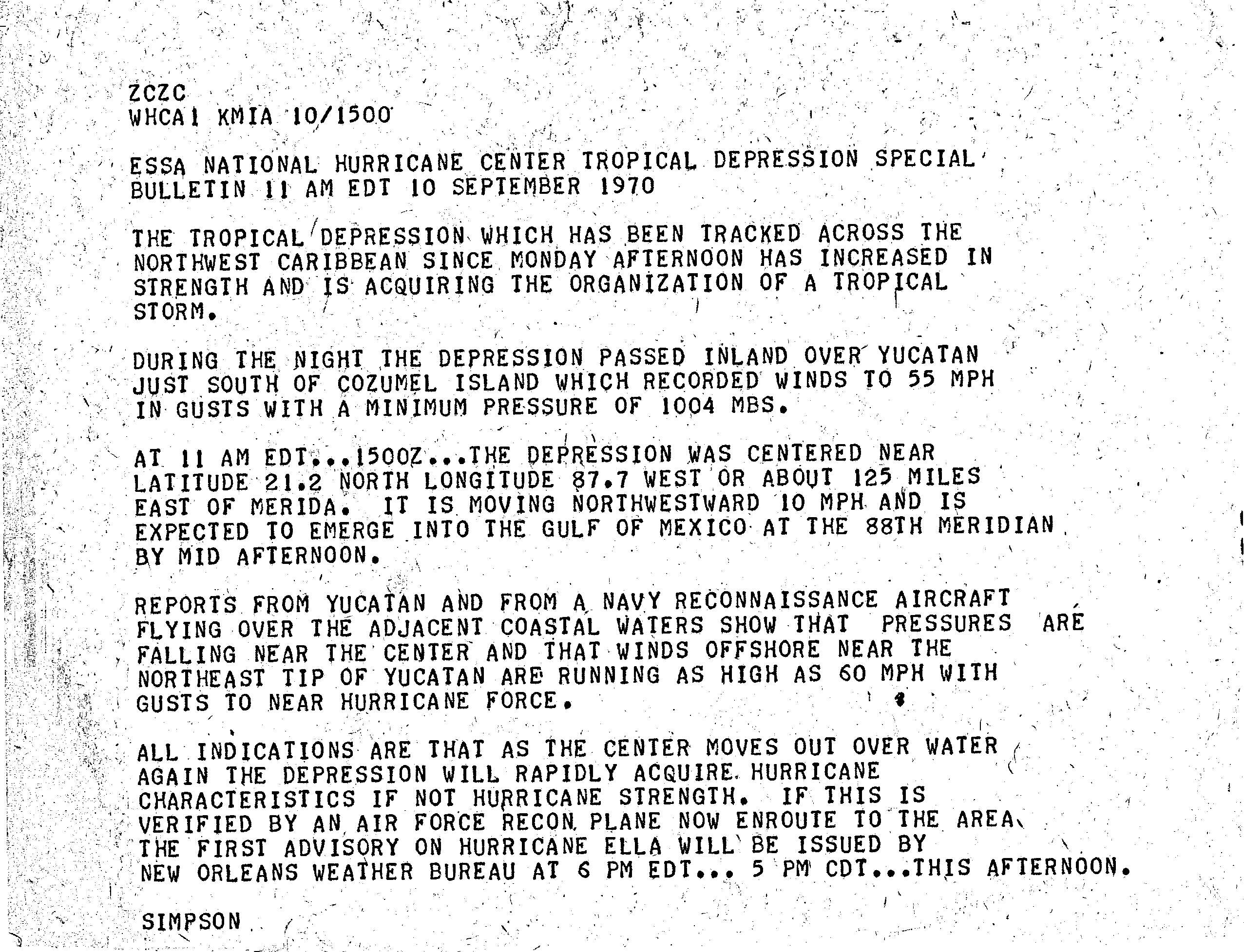
The origins of Hurricane Ella were from a well-defined trough that extended from the San Andres archipelago to Florida in early September. A tropical depression developed from the system on September 8 near Swan Island off the north coast of Honduras. Moving northwestward, the depression failed to strengthen much before striking the Yucatán Peninsula on September 10,[1] just south of Cozumel. As it emerged into the Gulf of Mexico, the depression began to intensify significantly.[2] A few hours later, the Hurricane Hunters observed a tropical storm, which prompted the system being named "Ella". Around that time, the storm started a general curve toward the west, due to a ridge to its north. With an anticyclone aloft providing favorable conditions, Ella rapidly intensified into a hurricane less than 12 hours after emerging from the Yucatán Peninsula.[1]
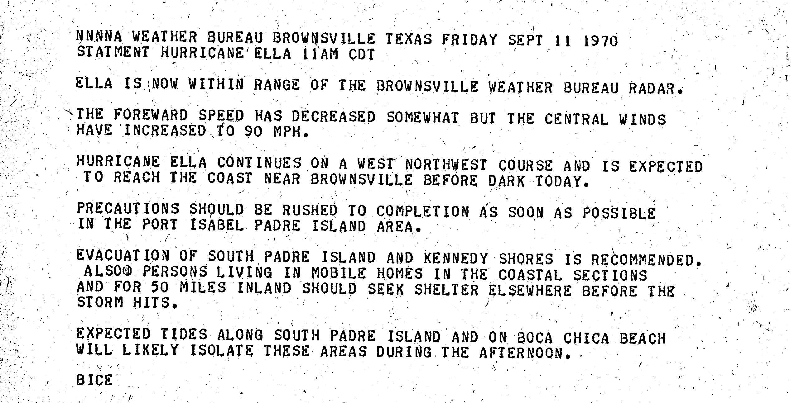
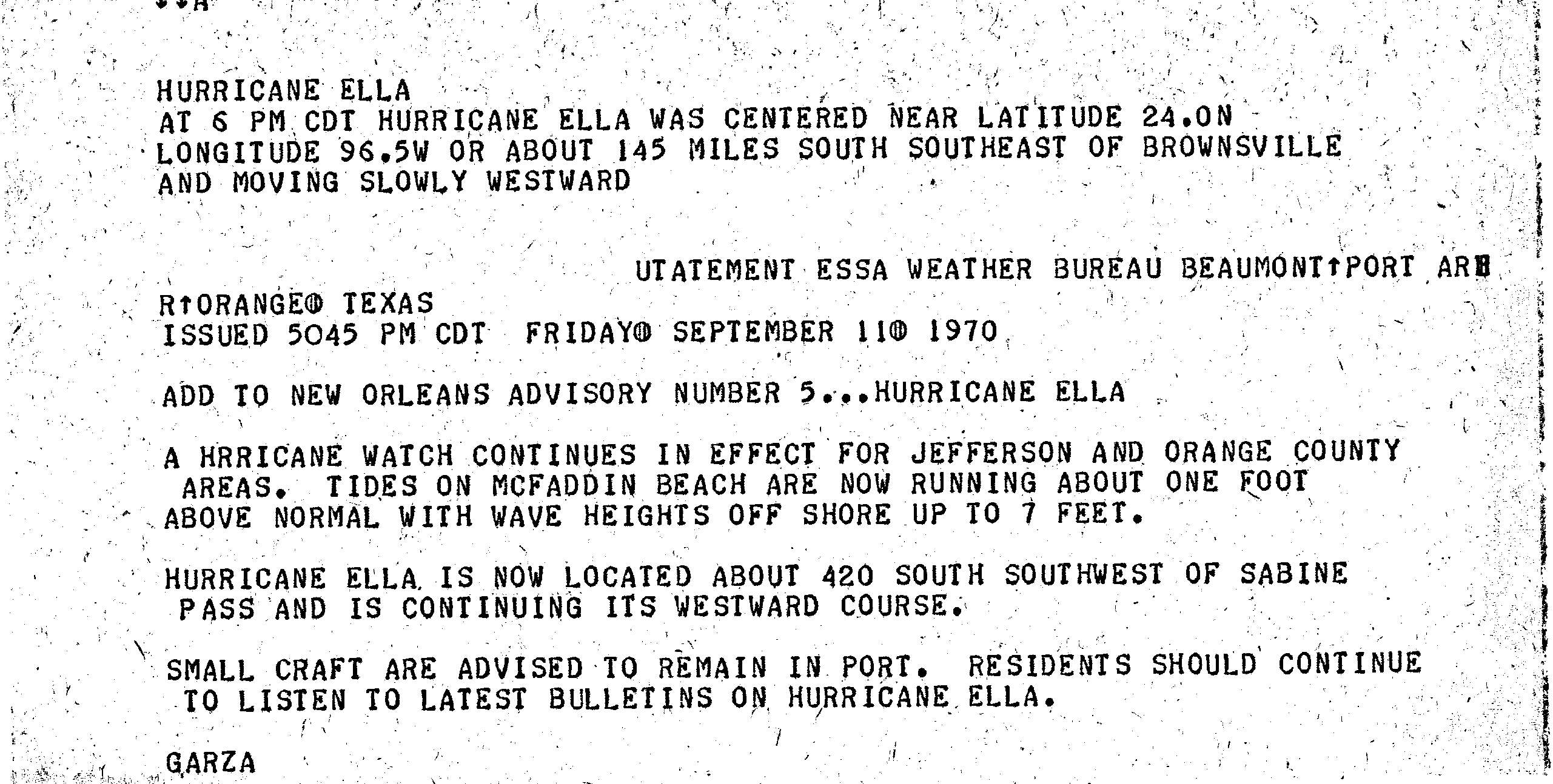
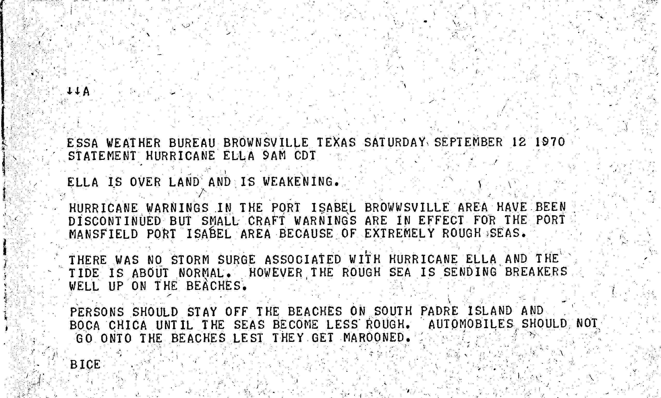
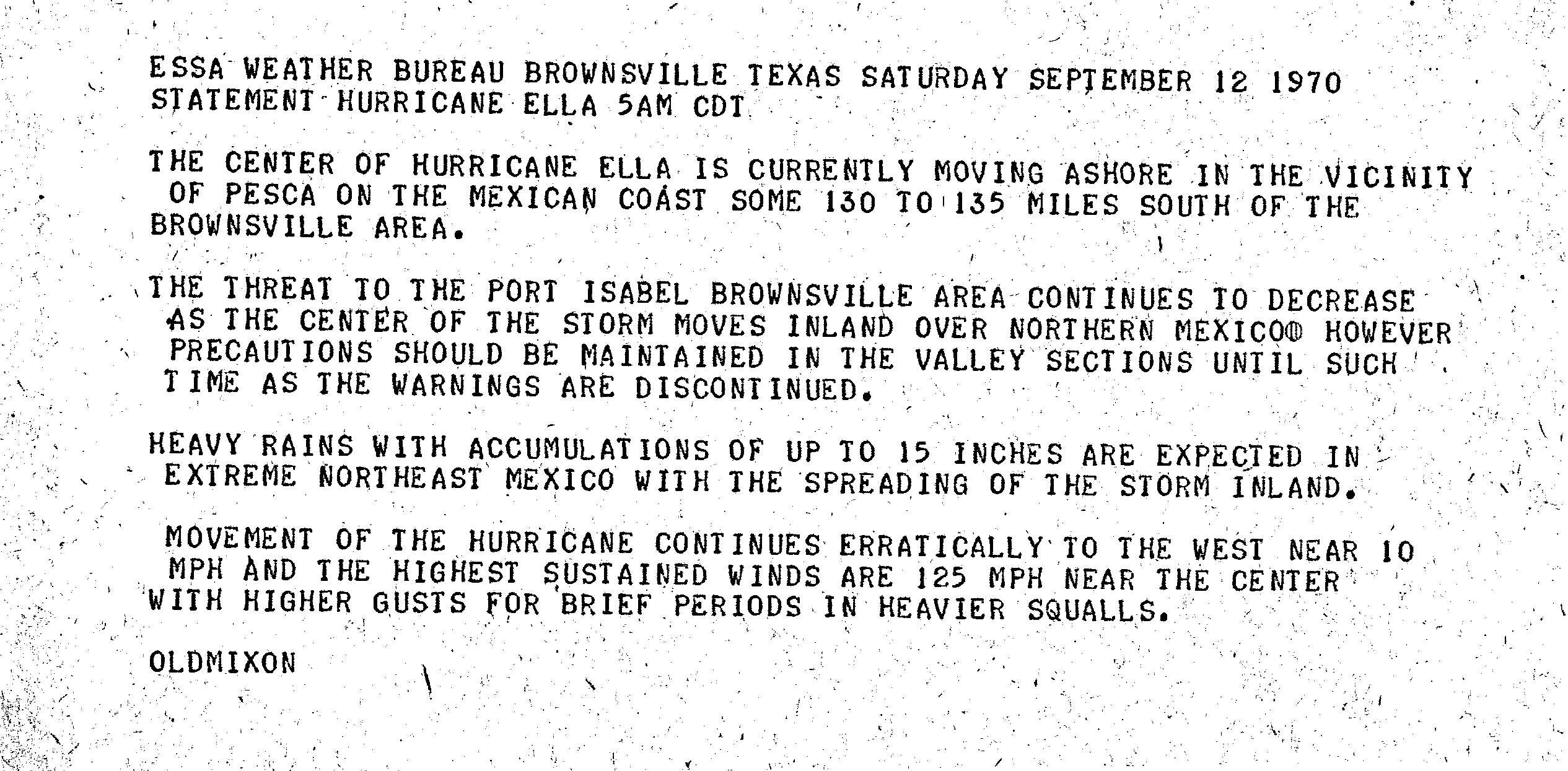
Initially there was uncertainty in its future track, and the hurricane posed a threat to Texas; however, Ella turned to the west as its intensification rate slowed. About 24 hours before its final landfall, its center became trackable on radar from Brownsville, Texas. As the ridge to the north weakened, Ella slowed its forward motion markedly and quickly strengthened.[1] In the 12 hours before moving ashore, the winds increased from 100 mph (160 km/h) to 125 mph (201 km/h), making Ella a major hurricane (Category 3 on the Saffir-Simpson Hurricane Scale).[3] On September 12, the hurricane made landfall near La Pesca, Tamaulipas, about 150 mi (220 km) south of the Mexico/United States border, with a barometric pressure of 967 mbar (28.6 inHg).[1] This made Ella one of eleven major hurricanes to strike the Atlantic coast of Mexico in the period between 1970 and 2008.[4] It rapidly weakened over land, dissipating early on September 13 over western Nuevo León.[3]
As the tropical depression that became Ella moved over the Yucatán Peninsula, it produced wind gusts of 55 mph (89 km/h) and a pressure of 1,004 mbar (29.6 inHg).[2]
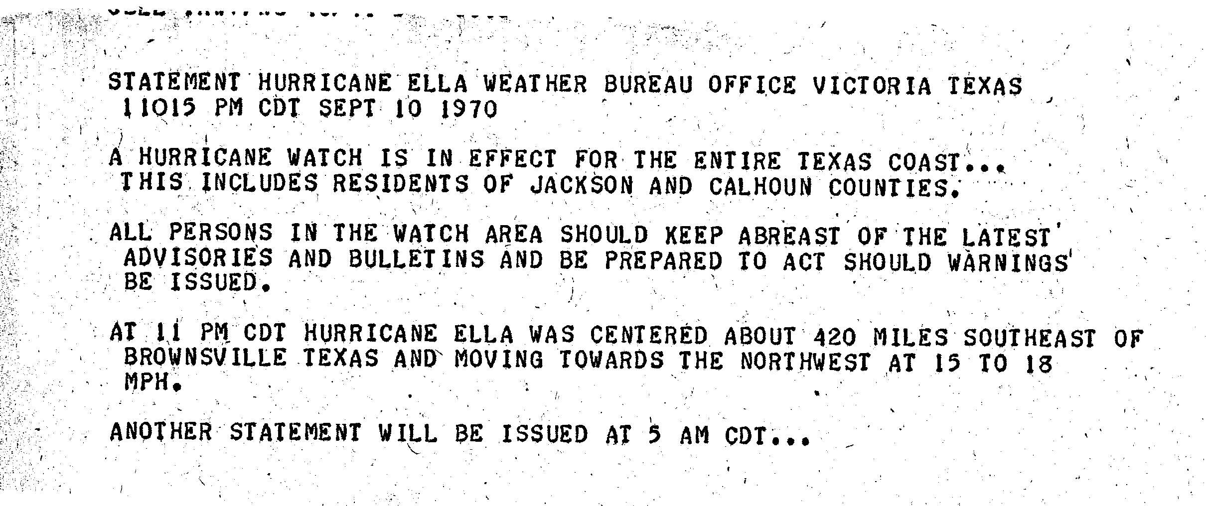
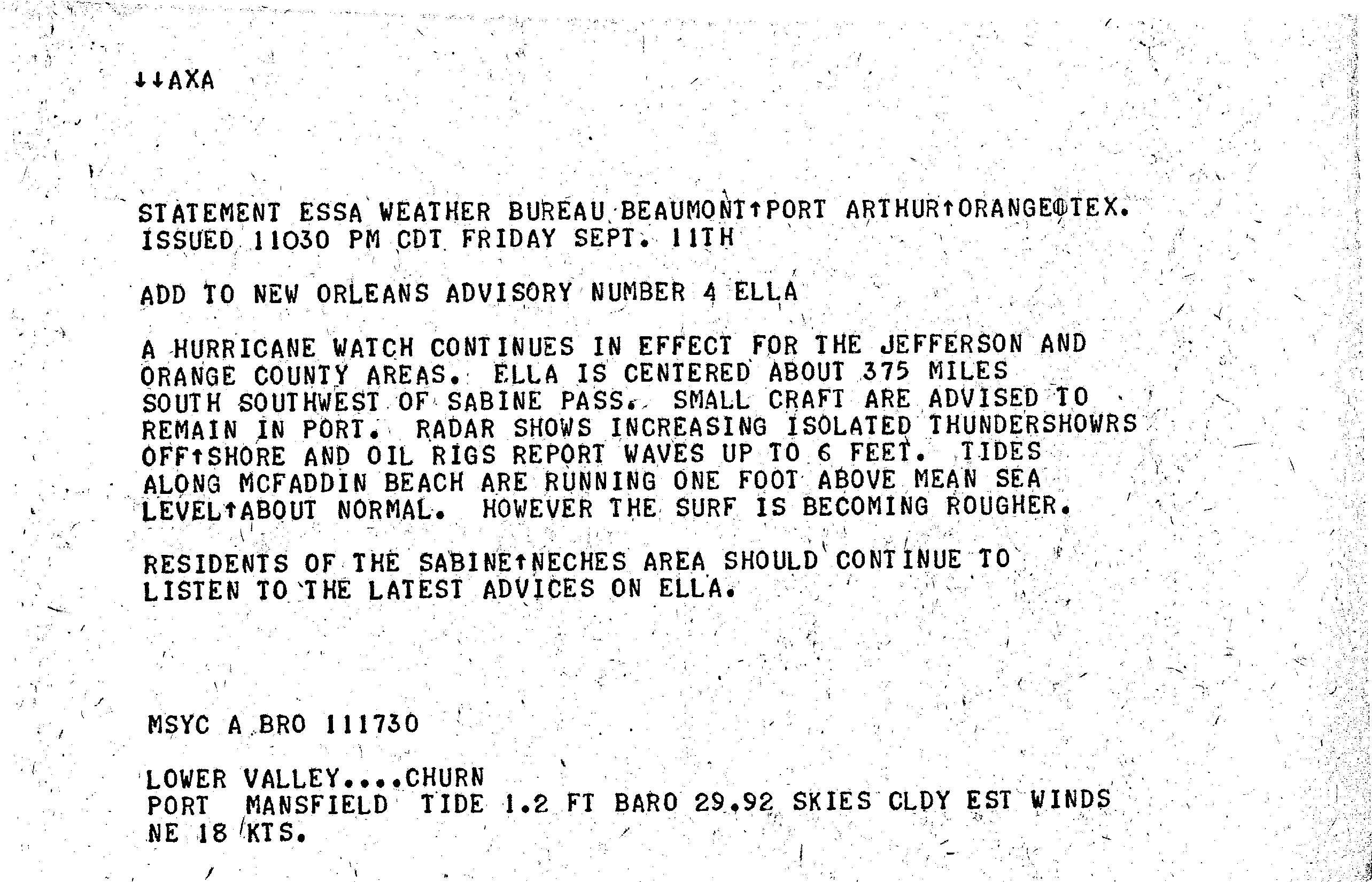
When Hurricane Ella was still moving to the west-northwest,[1] the Weather Bureau issued a hurricane watch for the entire Texas coastline.[5] This was later upgraded to a hurricane warning from Brownsville to Port Isabel, with gale warnings extending northward to Port Aransas.[1] Officials issued a mandatory evacuation for low-lying areas around Brownsville, as well as in South Padre Island and Port Isabel. An American Red Cross shelter opened to provide shelter.[6] All residents in mobile homes were also told to leave their homes in the Brownsville area.[7] People in the affected area took extra precautions due to the heavy damage left by Hurricane Celia only weeks before.[6]
The hurricane increased surf along the Texas coast, with wave heights of 7 ft (2.1 m) observed.[8] As a result, small craft were recommended to remain at port.[9] Ultimately there was no reported storm surge in Texas, although the waves crested high along the beaches.[10] Precipitation was light in Texas, peaking at 0.88 in (22 mm) at McAllen.[11] Observations in northeastern Mexico were sparse, although wind gusts from Ella reached 150 mph (240 km/h).[1] The Brownsville Weather Bureau office noted the potential for 15 in (380 mm) of rainfall to occur in Mexico along the hurricane's path,[12] and heavy rainfall occurred in portions of northeastern Mexico.[13] Winds up to 80 mph (130 km/h) were reported in Ciudad Victoria.[14] There, the rainfall disrupted post-storm rescue work. The rains prevented the transportation of relief goods, including food and medicine, by helicopters.[15] The hurricane destroyed several houses,[11] and there was one death after a girl was stuck in her destroyed house in Abasolo.[15][16] Due to the hurricane, the Purification and the San Fernando Rivers crested above flood stage.[1]
- R.H. Simpson; Joseph M. Pelissier (April 1971). "Atlantic hurricane season of 1970" (PDF). Monthly Weather Review. 4 (9): 275–276. Bibcode:1971MWRv...99..269S. doi:10.1175/1520-0493(1971)099<0269:AHSO>2.3.CO;2. Retrieved 2011-09-12.
- R.H. Simpson (1970-09-10). "Tropical Depression Special Bulletin" (JPG). Retrieved 2011-09-12.
- "Atlantic hurricane best track (HURDAT version 2)" (Database). United States National Hurricane Center. April 5, 2023. Retrieved April 16, 2024.
 This article incorporates text from this source, which is in the public domain.
 - Alberto Hdz. Unzón. "Huracanes sobre Méxicode 1970 a 2008" (PDF). Comicián Nacional del Agua. Archived from the original (PDF) on 2011-09-10. Retrieved 2011-09-12.
- Victoria, Texas Weather Bureau Office (1970-09-10). "Hurricane Ella Statement" (JPG). National Hurricane Center. Retrieved 2011-09-12.
- Gary Garrison (1970-09-11). "Ella is Racing Toward Texas Coast". Kentucky New Era. Associated Press. Retrieved 2011-09-13.
- Brownsville Weather Bureau Office (1970-09-11). "Hurricane Ella Statement" (JPG). National Hurricane Center. Retrieved 2011-09-13.
- Beaumont/Port Arthur Weather Bureau Office (1970-09-11). "Hurricane Ella" (JPG). National Hurricane Center. Retrieved 2011-09-13.
- Beaumont/Port Arthur Weather Bureau Office (1970-09-11). "Hurricane Ella Statement" (JPG). National Hurricane Center. Retrieved 2011-09-13.
- Bice, Beaumont/Port Arthur Weather Bureau Office (1970-09-12). "Hurricane Ella Statement" (JPG). National Hurricane Center. Retrieved 2011-09-13.
- Staff Writer (1970-09-12). "Ella Misses U.S." Youngstown Vindicator. Associated Press. Retrieved 2011-09-13.
- Beaumont/Port Arthur Weather Bureau Office (1970-09-12). "Hurricane Ella Statement" (JPG). National Hurricane Center. Retrieved 2011-09-13.
- Staff Writer (1970-09-12). "Hurricane Ella powers way towards Mexican coastline". Edmonton Journal. Associated Press. Retrieved 2011-09-13.
- "Hurricane Ella Wanes In Mexico". The Times Record. Brownsville, Texas. United Press International. September 14, 1970. p. 4. Retrieved August 4, 2016 – via Newspapers.com.

- "Heavy Rains". The Eagle. Tampico, Mexico. Associated Press. September 14, 1970. p. 1. Retrieved August 4, 2016 – via Newspapers.com.