| Name |
Location |
Date Listed |
Grid Ref. [note 1] |
Geo-coordinates |
Notes |
LB Number [note 2] |
Image |
| Abercorn Church |
Abercorn |
|
NT081790 |
55°59′44″N 3°28′27″W |
12th-century church with later alterations[5] |
612
|  Upload another image
See more images
|
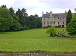
| Hopetoun House |
4 kilometres (2.5 mi) west of South Queensferry |
|
NT088790 |
55°59′45″N 3°27′47″W |
Late 17th-century country house[6] |
613
|  Upload another image
See more images
|
| Hopetoun House estate buildings and steading |
Hopetoun House Estate |
|
NT0901678851 |
55°59′38″N 3°27′37″W |
18th-century estate buildings[7] |
614 |

Upload Photo
|
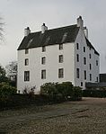
| Midhope Castle |
Abercorn |
|
NT0728378685 |
55°59′32″N 3°29′16″W |
16th-century tower house[8] |
630
|  Upload another image
See more images
|
| House of the Binns |
1.5 kilometres (0.93 mi) south of Blackness |
|
NT0508078567 |
55°59′26″N 3°31′23″W |
Country house dating to 1612–1630[9] |
632
|  Upload another image
See more images
|
| Duntarvie Castle |
2km north of Winchburgh |
|
NT0905076477 |
55°58′22″N 3°27′32″W |
Scots Renaissance house of circa 1590[10] |
6422
|  Upload another image
See more images
|
| Bangour Village Hospital, excluding villas 9, 23–29, 31, and boiler house |
1 kilometre (0.62 mi) west of Dechmont |
|
NT0322171218 |
55°55′27″N 3°33′01″W |
Former hospital built 1898–1906, and church dating from the 1920s[11] |
6588
|  Upload another image
See more images
|
| Hatton House, south entrance gates |
2 kilometres (1.2 mi) south of Ratho |
|
NT1279968444 |
55°54′04″N 3°23′46″W |
Gateway built 1692 as an entrance to the now-demolished Hatton House[12] |
7355
|  Upload another image
See more images
|
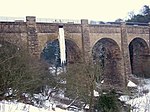
| Linhouse Water Viaduct |
1.5 kilometres (0.93 mi) east of Murieston |
|
NT076647 |
55°52′01″N 3°28′38″W |
1842 railway viaduct carrying the Edinburgh to Carstairs railway over the Linhouse Water[13] |
7365
|  Upload another image
See more images
|
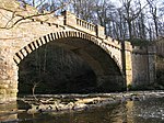
| Almondell Bridge |
1 kilometre (0.62 mi) north of East Calder in Almondell and Calderwood Country Park |
|
NT0881668838 |
55°54′14″N 3°27′36″W |
1800 bridge over the River Almond[14][15][note 3] |
7370
|  Upload another image
See more images
|
| Almondell Bridge |
1 kilometre (0.62 mi) north of East Calder in Almondell and Calderwood Country Park |
|
NT0881668838 |
55°54′14″N 3°27′36″W |
1800 bridge over the River Almond[14][15][note 4] |
14228
| Upload another image
See more images
|
| Almondell Aqueduct |
Almondell and Calderwood Country Park, East Calder |
|
NT0864068528 |
55°54′04″N 3°27′46″W |
1820 aqueduct built to feed the Union Canal[16] |
7371
|  Upload another image
See more images
|
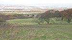
| Blackburn House |
Between Blackburn and Seafield |
|
NT000656 |
55°52′25″N 3°35′56″W |
18th-century country house[17] |
7419
|  Upload another image
See more images
|
| Broxburn Viaduct |
2.5 kilometres (1.6 mi) east of Broxburn |
|
NT1057872525 |
55°56′15″N 3°25′59″W |
Railway viaduct carrying the Edinburgh to Glasgow railway over the A89 road[18] |
7427
|  Upload another image
See more images
|
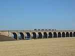
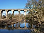
| Almond Valley Viaduct |
3 kilometres (1.9 mi) east of Broxburn |
|
NT1123772183 |
55°56′04″N 3°25′21″W |
1842 railway viaduct carrying the Edinburgh to Glasgow railway over the River Almond[19][note 5] |
7428
|  Upload another image
See more images
|
| Almond Aqueduct |
3 kilometres (1.9 mi) south-east of Broxburn |
|
NT104706 |
55°55′14″N 3°26′04″W |
1820 aqueduct carrying the Union Canal over the River Almond[20][note 5] |
7430
|  Upload another image
See more images
|
| Niddry Castle |
Near Winchburgh |
|
NT095743 |
55°57′13″N 3°27′00″W |
Tower house of circa 1500[21] |
7437
|  Upload another image
See more images
|
| Avon Aqueduct |
3 kilometres (1.9 mi) south-west of Linlithgow |
|
NS967758 |
55°57′52″N 3°39′20″W |
1822 aqueduct carrying the Union Canal over the River Almond[22][note 6] |
7468
|  Upload another image
See more images
|
| Kingscavil Cottages |
3 kilometres (1.9 mi) east of Linlithgow |
|
NT030764 |
55°58′16″N 3°33′18″W |
1873 cottages and former schoolhouse[23] |
7482
|  Upload another image
|
| Grange House |
1.5 kilometres (0.93 mi) north of Linlithgow |
|
NT0002878768 |
55°59′29″N 3°36′15″W |
Early 20th-century country house[24] |
12972 |
Upload Photo
|
| Ochiltree Castle |
3.5 kilometres (2.2 mi) south-east of Linlithgow |
|
NT0326474760 |
55°57′22″N 3°33′03″W |
Early 17th-century tower house[25] |
12978
|  Upload another image
See more images
|
| Preston House |
Preston Road, Linlithgow |
|
NS9957875849 |
55°57′54″N 3°36′37″W |
19th-century baronial house by William Burn and David Bryce[26] |
12983 |
Upload Photo
|
| Avon Viaduct |
Linlithgow Bridge |
|
NS9816076951 |
55°58′29″N 3°38′00″W |
1842 viaduct carrying the Edinburgh to Glasgow railway over the River Avon[27][note 6] |
12985
|  Upload another image
See more images
|
| Woodcockdale, cottages and stables |
2.5 kilometres (1.6 mi) south-west of Linlithgow |
|
NS9758775895 |
55°57′54″N 3°38′32″W |
Early 19th-century stables and cottages[28] |
12989
|  Upload another image
See more images
|
| Mid Calder Parish Church (St John's) |
Main Street, Mid Calder |
|
NT0737267323 |
55°53′24″N 3°28′57″W |
16th-century Gothic church[29] |
14144
|  Upload another image
See more images
|
| Calder House |
Mid Calder |
|
NT0725967251 |
55°53′22″N 3°29′04″W |
16th- or 17th-century mansion, incorporating walls of earlier fortalice[30] |
14153
|  Upload another image
See more images
|
| Calder House, east gateway |
West Calder Road, Mid Calder |
|
NT0742367187 |
55°53′20″N 3°28′54″W |
Ornamental gateway of circa 1670[31] |
14155
|  Upload another image
|
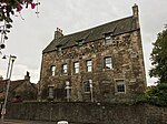
| Linhouse |
2 kilometres (1.2 mi) south of Murieston |
|
NT062629 |
55°51′02″N 3°29′56″W |
1589 country house[32] |
14156 |
Upload Photo
|
| Houstoun House |
Uphall |
|
NT0526471334 |
55°55′33″N 3°31′04″W |
17th-century house, now a hotel[33] |
14243
|  Upload another image
|
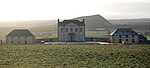
| Gowanbank |
3 kilometres (1.9 mi) north-west of Armadale |
|
NS9157071261 |
55°55′20″N 3°44′12″W |
19th-century farmhouse, steading and cottage by Sir James Gowans[34] |
14557
|  Upload another image
|
| Bathgate Academy |
Marjoribanks Street, Bathgate |
|
NS9794768697 |
55°54′02″N 3°38′01″W |
19th-century Greek revival school[35] |
22125
|  Upload another image
See more images
|
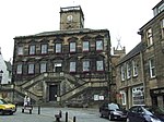
| Linlithgow Burgh Halls |
The Cross, Linlithgow |
|
NT0021977204 |
55°58′39″N 3°36′02″W |
17th-century town house, including former jail and court house[36] |
37362
|  Upload another image
See more images
|
| Cross House |
5 The Cross, Linlithgow |
|
NT0018277195 |
55°58′38″N 3°36′04″W |
18th-century house, Category A listed for its interiors[37] |
37363
|  Upload another image
See more images
|
| St Michael's Well |
High Street, Linlithgow |
|
NT0041377119 |
55°58′36″N 3°35′51″W |
Well dated 1720 with a statue of St Michael[38] |
37383
|  Upload another image
|
| West Port House |
297–299 High Street, Linlithgow |
|
NS9965377027 |
55°58′33″N 3°36′34″W |
Laird's house, circa 1600 with later additions[39] |
37430
|  Upload another image
|
| Hamilton's Land |
38–44 High Street, Linlithgow |
|
NT0039877139 |
55°58′37″N 3°35′52″W |
Early 17th-century tenement building, restored 1958[40] |
37438
|  Upload another image
|
| Hamilton's Land |
46–48 High Street, Linlithgow |
|
NT0038977143 |
55°58′37″N 3°35′52″W |
Early 17th-century tenement building, restored 1958[41] |
37439 |
Upload Photo
|
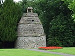
| Dovecot |
Learmonth Gardens, Linlithgow |
|
NT0034577008 |
55°58′32″N 3°35′54″W |
16th-century beehive dovecote[42] |
37468
|  Upload another image
See more images
|
| Linlithgow Palace |
Linlithgow Peel |
|
NT0019677325 |
55°58′43″N 3°36′03″W |
Former royal palace built over 15th to 17th centuries, now in ruins[43] |
37469
|  Upload another image
See more images
|
| Linlithgow Palace Gateway |
Linlithgow Peel |
|
NT0019677279 |
55°58′41″N 3°36′03″W |
Gateway to former royal palace, circa 1535[44] |
37470
|  Upload another image
See more images
|
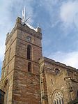
| St Michael's Church |
Linlithgow Peel |
|
NT002772 |
55°58′40″N 3°36′00″W |
15th-century parish church[45] |
37499
|  Upload another image
See more images
|
| Brucefield Church |
East Main Street, Whitburn, West Lothian |
4 December 2008 |
NS9485765021 |
55°52′01″N 3°40′54″W |
Rowand Anderson, Kininmonth and Paul (William Kininmonth and Tom Duncan) |
51254
|  Upload another image
See more images |


.jpg)


