County
|
FIPS code[1]
|
County seat[2]
|
Est.[2]
|
Origin[3]
|
License plate prefix[4] | Etymology
[5] |
Population[6] |
Area[2] |
Map |
| Ada County |
001 |
Boise | 1864 | Boise County | 1A | Ada Riggs (1856-1909), daughter of H. C. Riggs, a member of the Idaho Territorial Legislature. |
524,673 |
1,055 sq mi
(2,732 km2) |  |
| Adams County |
003 |
Council | 1911 | Washington County | 2A | John Adams (1735–1826), second President of the United States (1797–1801). |
4,903 |
1,365 sq mi
(3,535 km2) |  |
| Bannock County |
005 |
Pocatello | 1893 | Bingham County | 1B | Bannock Native American tribe. |
90,400 |
1,113 sq mi
(2,883 km2) |  |
| Bear Lake County |
007 |
Paris | 1875 | Oneida County | 2B | Bear Lake on the Utah/Idaho border. |
6,766 |
971 sq mi
(2,515 km2) | 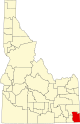 |
| Benewah County |
009 |
St. Maries | 1915 | Kootenai County | 3B | Ben'wah, chief of the Coeur d'Alene Tribe |
10,369 |
776 sq mi
(2,010 km2) |  |
| Bingham County |
011 |
Blackfoot | 1885 | Oneida County | 4B | Henry H. Bingham (1841-1912), a general in the American Civil War and a U.S. Congressman from Pennsylvania. |
50,395 |
2,095 sq mi
(5,426 km2) | 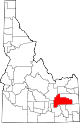 |
| Blaine County |
013 |
Hailey | 1895 | Alturas and Logan Counties | 5B | James G. Blaine (1830-1893), United States Secretary of State (1881, 1889-1892). |
25,041 |
2,645 sq mi
(6,851 km2) | 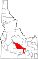 |
| Boise County |
015 |
Idaho City | 1864 | original county | 6B | Boise River |
8,517 |
1,902 sq mi
(4,926 km2) |  |
| Bonner County |
017 |
Sandpoint | 1907 | Kootenai County | 7B | Edwin L. Bonner (1834-1902), originator of an 1864 ferry service on the Kootenai River. |
52,547 |
1,738 sq mi
(4,501 km2) |  |
| Bonneville County |
019 |
Idaho Falls | 1911 | Bingham County | 8B | Benjamin Bonneville (1796-1878), a French-born explorer of the West. |
131,366 |
1,869 sq mi
(4,841 km2) |  |
| Boundary County |
021 |
Bonners Ferry | 1915 | Bonner County | 9B | Borders Canada on the north. |
13,557 |
1,269 sq mi
(3,287 km2) |  |
| Butte County |
023 |
Arco | 1917 | Bingham, Blaine, and Jefferson Counties | 10B | Buttes rising from the Snake River Plain. |
2,758 |
2,233 sq mi
(5,783 km2) |  |
| Camas County |
025 |
Fairfield | 1917 | Blaine County | 1C | Camassia, a plant species important as a food source among Native Americans and early settlers. |
1,232 |
1,077 sq mi
(2,789 km2) |  |
| Canyon County |
027 |
Caldwell | 1892 | Ada County | 2C | Disputed, either a canyon of the Boise River near Caldwell or a canyon of the Snake River which forms part of the county's boundary. |
257,674 |
590 sq mi
(1,528 km2) |  |
| Caribou County |
029 |
Soda Springs | 1919 | Bannock County | 3C | Caribou Mountains |
7,219 |
1,766 sq mi
(4,574 km2) | 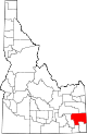 |
| Cassia County |
031 |
Burley | 1879 | Owyhee County | 4C | Disputed, either Cassia Creek or a member of the Mormon Battalion, James John Cazier (1821-1890). |
25,696 |
2,567 sq mi
(6,648 km2) |  |
| Clark County |
033 |
Dubois | 1919 | Fremont County | 5C | Sam K. Clark (1857-1933), early settler and a member of the Idaho Senate. |
801 |
1,765 sq mi
(4,571 km2) |  |
| Clearwater County |
035 |
Orofino | 1911 | Nez Perce County | 6C | Clearwater River |
9,214 |
2,462 sq mi
(6,377 km2) |  |
| Custer County |
037 |
Challis | 1881 | Alturas and Lemhi Counties | 7C | General Custer mine, named after George Armstrong Custer (1839-1876), United States Army general. |
4,523 |
4,926 sq mi
(12,758 km2) |  |
| Elmore County |
039 |
Mountain Home | 1889 | Alturas County | E | Ida Elmore mines, locally noted for gold and silver production in the 1860s. |
29,724 |
3,078 sq mi
(7,972 km2) | 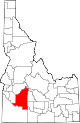 |
| Franklin County |
041 |
Preston | 1913 | Oneida County | 1F | Franklin D. Richards (1821-1899), early LDS Church apostle. |
15,494 |
666 sq mi
(1,725 km2) | 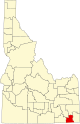 |
| Fremont County |
043 |
Saint Anthony | 1893 | Bingham County | 2F | John C. Frémont (1813-1890), an explorer of the West. |
14,196 |
1,867 sq mi
(4,836 km2) | 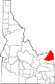 |
| Gem County |
045 |
Emmett | 1915 | Boise and Canyon Counties | 1G | State nickname of "Gem State." |
21,071 |
563 sq mi
(1,458 km2) |  |
| Gooding County |
047 |
Gooding | 1913 | Lincoln County | 2G | Frank R. Gooding (1859-1928), seventh Governor of Idaho (1905-1909), U.S. Senator (1921-1928). |
16,061 |
731 sq mi
(1,893 km2) |  |
| Idaho County |
049 |
Grangeville | 1864 | original county | I | Columbia River steamship Idaho launched in 1860. Name predates both Idaho Territory and the State of Idaho. |
17,890 |
8,485 sq mi
(21,976 km2) | 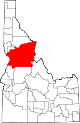 |
| Jefferson County |
051 |
Rigby | 1913 | Fremont County | 1J | Thomas Jefferson (1743-1826), third President of the United States (1801-1809). |
34,198 |
1,095 sq mi
(2,836 km2) |  |
| Jerome County |
053 |
Jerome | 1919 | Gooding and Lincoln Counties | 2J | Disputed, either North Side Irrigation Project developer Jerome Hill, his son-in-law Jerome Kuhn (1898-1952), or his grandson Jerome Kuhn, Jr. |
25,479 |
600 sq mi
(1,554 km2) | 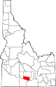 |
| Kootenai County |
055 |
Coeur d'Alene | 1864 | Nez Perce County | K | Kootenai Native American tribe. |
185,010 |
1,245 sq mi
(3,225 km2) | 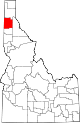 |
| Latah County |
057 |
Moscow | 1888 | Nez Perce County | 1L | Latah Creek, Nez Perce for "the place of pine trees and sestle." |
41,301 |
1,077 sq mi
(2,789 km2) |  |
| Lemhi County |
059 |
Salmon | 1869 | Idaho County | 2L | Limhi, king of the Nephites according to the Book of Mormon. |
8,441 |
4,564 sq mi
(11,821 km2) |  |
| Lewis County |
061 |
Nezperce | 1911 | Nez Perce County | 3L | Meriwether Lewis (1774-1809), a leader of the Lewis and Clark Expedition. |
3,739 |
479 sq mi
(1,241 km2) |  |
| Lincoln County |
063 |
Shoshone | 1895 | Blaine County | 4L | Abraham Lincoln (1809-1865), sixteenth President of the United States (1861-1865). Idaho Territory was founded under Lincoln's administration. |
5,450 |
1,206 sq mi
(3,124 km2) |  |
| Madison County |
065 |
Rexburg | 1913 | Fremont County | 1M | James Madison (1751-1836), fourth President of the United States (1809-1817). |
54,547 |
472 sq mi
(1,222 km2) | 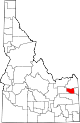 |
| Minidoka County |
067 |
Rupert | 1913 | Lincoln County | 2M | Disputed Native American origin, either Lakota for "a fountain or spring of water" or Shoshoni for "broad expanse." |
22,480 |
760 sq mi
(1,968 km2) | 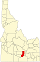 |
| Nez Perce County |
069 |
Lewiston | 1864 | original county | N | The Nez Perce, a Native American tribe. |
42,987 |
849 sq mi
(2,199 km2) | 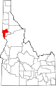 |
| Oneida County |
071 |
Malad City | 1864 | original county | 1O | Oneida Lake in New York state, where many early settlers were from. |
4,953 |
1,200 sq mi
(3,108 km2) | 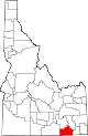 |
| Owyhee County |
073 |
Murphy | 1863 | original county | 2O | Alternate spelling of Hawaii. Hawaiian fur trappers explored the area in 1819 and 1820. |
12,722 |
7,678 sq mi
(19,886 km2) |  |
| Payette County |
075 |
Payette | 1917 | Canyon County | 1P | Francois Payette (1793-1844?), Canadian-born fur trader and early settler. |
27,279 |
408 sq mi
(1,057 km2) |  |
| Power County |
077 |
American Falls | 1913 | Bingham, Blaine, and Oneida Counties | 2P | The American Falls Power Plant |
8,253 |
1,406 sq mi
(3,642 km2) |  |
| Shoshone County |
079 |
Wallace | 1864 | original county | S | Shoshone Native American tribe. |
14,026 |
2,634 sq mi
(6,822 km2) |  |
| Teton County |
081 |
Driggs | 1915 | Bingham, Fremont, and Madison Counties | 1T | Teton Range in Wyoming. |
12,549 |
450 sq mi
(1,165 km2) | 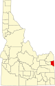 |
| Twin Falls County |
083 |
Twin Falls | 1907 | Cassia County | 2T | Twin Falls waterfall on the Snake River. |
95,156 |
1,925 sq mi
(4,986 km2) |  |
| Valley County |
085 |
Cascade | 1917 | Boise and Idaho Counties | V | Long Valley located in the county. |
12,644 |
3,733 sq mi
(9,668 km2) |  |
| Washington County |
087 |
Weiser | 1879 | Ada County | W | George Washington (1732-1799), first President of the United States (1789-1797). |
11,425 |
1,456 sq mi
(3,771 km2) | 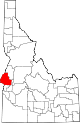 |


