List_of_highest_mountains_of_New_Guinea
This list of highest mountains of New Guinea shows all mountains on the island of New Guinea that are at least 3750 m high and have a topographic prominence of 500 m or more. These c. 50 peaks are also the highest mountains of Australasia and the continent of Australia, where, outside New Guinea, the highest mountain is Aoraki / Mount Cook in New Zealand with a height of 3724 m.[1] A list of highest mountains of Oceania with the same limitations is almost identical, with the addition of the Hawaiian volcanoes of Mauna Kea (4205 m) and Mauna Loa (4169 m) in 18th and 20th positions. The list also shows the 36 highest thus defined mountains of Indonesia, except for the 3805 m high Gunung Kerinci on Sumatra (#29 in Indonesia), and the 16 highest mountains of Papua New Guinea.
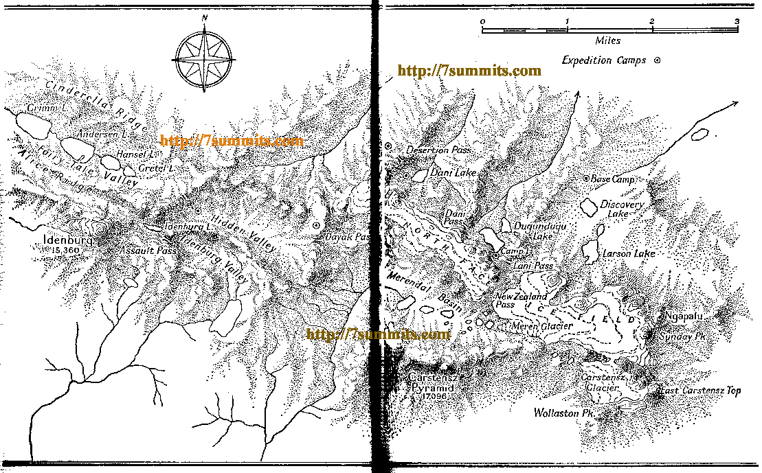
Many mountains in New Guinea are poorly surveyed and some major summits remain unnamed on maps. Even well measured mountains have conflicting heights on otherwise authoritative maps. For example, the highest point in Oceania, Carstensz Pyramid, was established to be 4884 m in 1973 when an Australian survey expedition put a beacon on the summit. This corresponded closely to the 4866 m estimate by the first Lorentsz Expedition in 1910 using repeated theodolite observations from the south coast. However, over time the mountain had grown in stature: measurements from northern observation peaks for the highest summit (each time Ngga Pulu) were 5000 m in 1910 by Ludolph Doorman and 5030 m in 1926 by Charles C.F.M. Le Roux.[2] The 1936 Carstensz Expedition using barometric and boiling point measurements on the summit of Ngga Pulu also derived an elevation of 5030 m.[3] After ascending the Pyramid in 1962, Heinrich Harrer even estimated that peak to be 17,096 feet or 5211 m high.[4] The 1973 survey established that the 1936 barometric estimates were consistently between 118 and 127 m too high. Nevertheless, the 5030 m height is still prevalent in most atlases and maps.[5]
All mountains in West Papua are in the Maoke Mountains, a translation of the name “Sneeuwgebergte” or Snowy Mountains endowed to them in 1623 by Jan Carstensz, at which time many of the peaks indeed were covered by extensive ice caps. By the beginning of the 20th century, at least five such glaciated regions remained on the highest mountains. In 1913, the 4520–4550 m high Prins Hendrik-top (now Puncak Yamin) was named and reported to have some "eternal" snow.[6] The ice cap of Wilhelmina Peaks vanished between 1939 and 1963, while the Mandala / Juliana ice cap disappeared in the 1990s.[7] The Idenburg glacier on Ngga Pilimsit dried up in 2003, leaving currently only the remnants of the glaciers on Mount Carstensz, the last of which are expected to disappear before 2025 [8] and perhaps much earlier.[9] The snow melt on the last mountain has caused a change of the highest summit of New Guinea: somewhere between 1936 and 1973 the title of highest summit of Oceania changed from Ngga Pulu, the highest point of the Northwall Firn (by then split into the West and East Northwall Firn; only small patches of the latter still exist), to the rocky spires of Carstensz Pyramid 3 km to its south-west.[10]
Download coordinates as:
The list contains some unranked summits that are either of general interest, may show topographic prominences of >500 m given better data, or are more than 12 km isolated from any higher point.
| Rank [11] | Mountain [12] | Height (m) [13] | Range | Country (rank) | Coordinates[14] | Prominence (m)[15] | Isolation (km) [16] | First ascent [17] |
|---|---|---|---|---|---|---|---|---|
| 1 | Puncak Jaya / Carstensz Pyramid | 4884 | Western Sudirman/Nassau | Indonesia (1) | 04°04′43″S 137°09′30″E | 4884 | 5261 | 13 Feb 1962 |
| Sumantri / Ngga Pulu NW [18] | 4870 | Western Sudirman/Nassau | Indonesia | 04°03′43″S 137°11′06″E | 350 | 3.5 | Feb 1962 | |
| Ngga Pulu[19] | 4862 | Western Sudirman/Nassau | Indonesia | 04°03′59″S 137°11′16″E | 100 | 0.6 | 5 Dec 1936 | |
| Carstensz East | 4820 | Western Sudirman/Nassau | Indonesia | 04°05′00″S 137°11′06″E | 280 | 1.9 | 5 Dec 1936 | |
| 2 | Mandala / Juliana Pk / Abom[20] | 4760 | Jayawijaya / Orange [21] | Indonesia (2) | 04°42′31″S 140°17′22″E | 2760 | 351.4 | 9 Sep 1959 |
| 3 | Trikora / Wilhelmina Pk[22] | 4730 | Eastern Sudirman / Nassau[21] | Indonesia (3) | 04°15′44″S 138°40′54″E | 1262 | 167.0 | 21 Feb 1913 |
| 4 | Ngga Pilimsit / Idenburg Pk [23] | 4717 | Western Sudirman/Nassau | Indonesia (4) | 04°02′08″S 137°03′33″E | 557 [24] | 11.1 | 21 Feb 1962 |
| 5 | Yamin / Prins Hendrik Pk | 4540 | Jayawijaya / Orange | Indonesia (5) | 04°40′59″S 140°04′52″E | 700 | 20.0 | |
| 6 | Cornelis Speelman Mts | 4540 | Jayawijaya / Orange | Indonesia (6) | 04°34′28″S 140°08′14″E | 700 | 18.2 | |
| 7 | Mt Wilhelm / Enduwa Kombuglu | 4509 | Bismarck Range | Papua New Guinea (1) | 05°46′48″S 145°01′46″E | 2969 | 537.7 | 15 Aug 1938 |
| 8 | J P Coen Pk [25] | 4500 | Jayawijaya / Orange | Indonesia (7) | 04°18′16″S 139°37′53″E | 820 | 63.5 | |
| 9 | Pt 4460 [26] | 4460 | Western Sudirman/Nassau | Indonesia (8) | 04°05′04″S 137°20′59″E | 600 | 17.2 | |
| 10 | Valentijn Pks [25] | 4453 | Jayawijaya / Orange | Indonesia (9) | 04°25′12″S 139°44′08″E | 640 | 17.1 | |
| Dom / Platen Spitz [fr] | 4420 | Western Sudirman/Nassau | Indonesia | 04°05′29″S 137°08′02″E | 460 | 2.1 | ||
| Akimuga / Prince Willem I Pk | 4390 | Western Sudirman/Nassau | Indonesia | 04°06′47″S 137°27′56″E | 340 | 12.3 | ||
| 11 | Zaagtoppen (Saw Mtns) | 4380 | Jayawijaya / Orange | Indonesia (10) | 04°33′01″S 139°55′06″E | 680 | 19.1 | |
| 12 | Mt Giluwe | 4367 | New Guinea Highlands | Papua New Guinea (2) | 06°02′36″S 143°53′11″E | 2507 | 129.5 | 16 Jun 1934 |
| 13 | Willem II Pk | 4360 | Eastern Sudirman/Nassau | Indonesia (11) | 04°09′43″S 138°20′24″E | 620 | 36.9 | |
| 14 | Ubia / Mt Leonard Darwin[27] | 4340 | Western Sudirman/Nassau | Indonesia (12) | 04°00′22″S 136°48′09″E | 580 | 20.3 | |
| Doema ? | 4340 | Western Sudirman/Nassau | Indonesia | 03°57′53″S 136°52′42″E | 340 | 12.2 | ||
| 15 | Willem I Pk | 4320 | Eastern Sudirman/Nassau | Indonesia (13) | 04°08′26″S 138°15′44″E | 660 | 8.9 | |
| 16 | Rumphius Pk | 4320 | Eastern Sudirman/Nassau | Indonesia (14) | 04°17′44″S 138°48′34″E | 540 | 13.0 | |
| 17 | Pt 4260 | 4300 | Jayawijaya / Orange | Indonesia (15) | 04°38′10″S 140°17′27″E | 540 | 5.4 | |
| Pt 4240 | 4240 | Eastern Sudirman/Nassau | Indonesia | 04°09′29″S 138°26′50″E | 400 | 11.6 | ||
| 18 | Prince Willem II Pk | 4220 | Eastern Sudirman/Nassau | Indonesia (16) | 04°09′01″S 137°56′57″E | 540 | 30.7 | |
| 19 | Pt 4180 | 4180 | Western Sudirman/Nassau | Indonesia (17) | 04°00′36″S 136°51′30″E | 600 | 5.1 | |
| 20 | Mt Boising / Gladstone [28] | 4155 | Finisterre Range | Papua New Guinea (3) | 05°57′14″S 146°22′31″E | 3710 | 148.4 | 25 June 2014 [29] |
| 21 | Mt Sarawaget / Bangeta[30] | 4121 | Saruwaged Range | Papua New Guinea (4) | 06°18′38″S 147°05′25″E | 1701 | 88.4 | 1912 |
| 22 | Mt Kabangama | 4104 | Kubor Range | Papua New Guinea (5) | 06°03′38″S 144°36′56″E | 2284 | 52.4 | |
| 23 | Pt 4100 [31] | 4100 | Maoke Range | Indonesia (18) | 03°57′26″S 137°44′57″E | 510 | 25.8 | |
| 24 | Ngga Nggulumbulu | 4061 | Nggulumbulu / Hens Range | Indonesia (19) | 03°45′30″S 137°18′40″E | 1300 | 32.5 | |
| Mt Kotewon ? | 4060 | Saruwaged Range | Papua New Guinea | 06°14′09″S 146°57′37″E | 460 | 16.2 | ||
| Pt 4040 | 4040 | Saruwaged Range | Papua New Guinea | 06°14′13″S 146°54′26″E | 460 | 5.9 | ||
| Prins Maurits Mtns | 4040 | Western Sudirman/Nassau | Indonesia | 04°06′08″S 137°39′10″E | 380 | 16.4 | ||
| 25 | Mt Victoria | 4038 | Owen Stanley Range | Papua New Guinea (6) | 08°53′34″S 147°31′59″E | 2738 | 287.8 | 11 Jun 1889 |
| Frederik Hendrik Pk | 4020 | Western Sudirman/Nassau | Indonesia | 04°05′29″S 137°46′02″E | 280 | 12.8 | ||
| 26 | Johan Willem Friso Pk | 4000 | Eastern Sudirman/Nassau | Indonesia (20) | 04°10′12″S 138°01′33″E | 560 | 2.9 | |
| 27 | Mt Albert Edward | 3993 | Owen Stanley Range | Papua New Guinea (7) | 08°24′44″S 147°24′12″E | 980 | 54.8 | 1906 |
| 28 | Antares[32] | 3970 | Star Mountains | Indonesia (21) | 04°53′46″S 140°54′15″E | 1360 | 63.7 | 6 Jul 1959 |
| 29 | Mt Kubor [33] | 3969 | Kubor Range | Papua New Guinea (8) | 06°06′06″S 144°45′36″E | 580 | 16.3 | |
| 30 | Mt Elit | 3960 | Jayawijaya / Orange | Indonesia (22) | 03°59′34″S 139°11′09″E | 720 | 36.8 | |
| 31 | Capella | 3960 | Star Mountains | Papua New Guinea (9) | 04°59′45″S 141°04′57″E | 670 | 22.6 | Apr or May 1965 |
| 32 | Pt 3960 | 3960 | Jayawijaya / Orange | Indonesia (23) | 04°19′34″S 139°26′26″E | 660 | 12.3 | |
| 33 | Angemuk | 3949 | Maoke Mountains | Indonesia (24) | 03°31′30″S 138°35′31″E | 1565 | 70.6 | |
| 34 | Pt 3940 | 3940 | Maoke Mountains | Indonesia (25) | 03°51′12″S 137°57′52″E | 800 | 24.4 | |
| 35 | Bondewit?/Yupnakabap? [34] | 3920 | Finisterre Range | Papua New Guinea (10) | 06°00′15″S 146°29′56″E | 820 | 9.3 | Jan or Feb 1965 |
| 36 | Tiom Mtns HP | 3915 | Tiom Mountains[35] | Indonesia (26) | 03°46′01″S 138°16′01″E | 720 | 34.9 | |
| 37 | Pt 3900 [26] | 3900 | Jayawijaya / Orange | Indonesia (27) | 04°16′35″S 139°18′58″E | 640 | 14.2 | |
| 38 | Mt Kegeraga | 3885 | Kubor Range | Papua New Guinea (11) | 06°01′48″S 144°23′23″E | 720 | 24.6 | |
| 39 | Pt 3860_Finisterre | 3860 | Finisterre Range | Papua New Guinea (12) | 05°47′38″S 146°06′33″E | 660 | 30.9 | |
| Pt 3860_Orange | 3860 | Jayawijaya / Orange | Indonesia | 04°09′31″S 139°13′03″E | 300 | 14.5 | ||
| 40 | Papua Peak 3856 | 3856 | Maoke Mountains | Indonesia (28) | 03°35′10″S 138°15′35″E | 1165 | 19.9 | |
| 41 | Mt Kumbepara[36] | 3852 | New Guinea Highlands | Papua New Guinea (13) | 05°30′26″S 143°02′52″E | 1100 | 106.1 | |
| Pt 12467 | 3840 | Jayawijaya / Orange | Indonesia | 04°42′34″S 140°28′08″E | 480 | 11.2 | ||
| 42 | Pt 3820 | 3820 | Maoke Mountains | Indonesia (29) | 03°55′02″S 138°02′16″E | 560 | 8.2 | |
| Mt Scratchley | 3820 | Owen Stanley Range | Papua New Guinea | 08°44′14″S 147°28′35″E | 480 | 16.4 | 23 Oct 1897[37] | |
| Pt 3820 | 3820 | Maoke Mountains | Indonesia | 03°50′00″S 138°24′45″E | 440 | 14.7 | ||
| 43 | X-chain HP | 3801 | Maoke Mountains (X-chain) | Indonesia (31) | 03°32′32″S 137°49′42″E | 1120 | 35.5 | |
| 44 | Pt 3800 | 3800 | Maoke Mountains | Indonesia (32) | 03°34′39″S 138°02′46″E | 600 | 23.4 | |
| 45 | Mt Kaijende [36][38] | 3798 | New Guinea Highlands | Papua New Guinea (15) | 05°28′25″S 143°11′50″E | 620 | 15.1 | |
| 46 | Jumbul Ambera | 3785 | Maoke Mountains | Indonesia (33) | 03°52′03″S 139°00′13″E | 1383 | 18.5 | |
| 47 | Mt Hagen[39] | 3778 | New Guinea Highlands | Papua New Guinea (14) | 05°44′38″S 144°02′34″E | 1080 | 29.3 | July 1933 |
| 48 | Z-chain high-point | 3774 | Maoke Mountains (Z-chain) | Indonesia (34) | 03°37′59″S 136°55′24″E | 1354 | 35.2 | |
| 49 | Mt Undan / Udon / Bedego [40] | 3774 | Bismarck Range | Papua New Guinea (16) | 05°48′02″S 144°51′12″E | 800 | 13.2 | |
| 50 | Pt 3760 | 3760 | Jayawijaya / Orange | Indonesia (35) | 04°41′33″S 140°30′32″E | 560 | 4.5 | |
| 51 | Kobowre HP/ Wakai[41] | 3750 | Kobowre / Weyland Mts | Indonesia (36) | 03°52′15″S 135°52′14″E | 2217 | 88.4 | |
| 52 | Wachter (Guardian) [42] | 3750 | Jayawijaya / Orange | Indonesia (37) | 04°27′30″S 139°27′48″E | 880 | 11.1 |
- Charles C.F.M. Le Roux, The Mountain Papuas of New Guinea and their environment, Volume 1, Leiden 1948, pp. 40 & 45.
- Heinrich Harrer's sketch map from Ich komme aus der Steinzeit. Pinguin, Innsbruck 1976, ISBN 3-524-00331-1.
- Edward G. Anderson, Topographic survey and cartography, in Hope, Geoff S, et al (Editors) 1976, The Equatorial Glaciers of New Guinea (Results of the 1971-1973 Australian Universities' Expeditions to Irian Jaya: survey, glaciology, meteorology, biology and palaeoenvironments), Rotterdam: A.A. Balkema. 1976, pp. 19-23.
- E.J. Brill, Tijdschrift van het Koninklijk Nederlandsch Aardrijkskundig Genootschap, 1913, p. 180.
- Klein, A.G., Kincaid, J.L., 2008. On the disappearance of the Puncak Mandala ice cap, Papua. Journal of Glaciology 54, 195–198.
- Klein, A.G. and J.L. Kincaid. 2006. Retreat of glaciers on Puncak Jaya, Irian Jaya, determined from 2000 and 2002 IKONOS satellite images. J. Glaciol., 52(176), 65–79.
- McDowell, Robin (July 1, 2010). "Indonesia's Last Glacier Will Melt 'Within Years'". Jakarta Globe. Archived from the original on August 16, 2011. Retrieved 2011-10-23.
- Anderson, p. 22, and Jean Jacques Dozy, Vom höchsten Gipfel bis in die tiefste Grube. Archived 2012-04-02 at the Wayback Machine, Bull. angew. Geol. 7:S.67-80. 2002.
- Only mountains with a prominence of 500 m or more are ranked.
- Most "round" heights are crude estimates from contour lines on Google terrain maps. Based on the average of carefully measured summit heights in the region, peaks are here presented to be 40 m higher than the highest encircling contour line.
- Extracted from the Google terrain maps.
- The prominence data were extracted from a combination of maps and Google terrain data. Values for mountains with prominences over 1,500 m were copied from the peaklist.org ultras website.
- The nearest higher elevation to Puncak Jaya is on the slopes of Yulong Xueshan in China.
- First documented ascent by Europeans.
- Measured in 1975 at 4855 m (Anderson, p. 21), but its exposed spire is now also higher than the neighboring, melting Ngga Pulu
- In 1936, the snow dome of Ngga Pulu seems to have been ca. 4900 m high and with that the highest summit in the Netherlands Indies and Oceania (Anderson p. 22). For this reason it became in 1963 the original bearer of the name Puntjak Sukarno and then Puntjak Djaja. However, snowmelt had lowered it to 4862 m by 1973 (Anderson, p. 22).
- An alternative height of 4640 m is inconsistent with 4720 m SRTM-contour lines around the summit.
- On some maps and in some sources the Jayawijaya / Orange range represents the eastern half of the Nassau range (from the 3475 m Jila Pass at 4°5′36″S 137°40′16″E to the Baliem gorge). The original Orange range is then often considered part of the Star mountains, the eastern section of the Jayawijaya range, or has the name Wisnumurti Range.
- Highest SRTM-contour lines are 4680 m.
- Probable location; alternatively the highest of the three Idenburg Peaks, climbed by Harrer and company in 1962, is 1.8 km to the ESE at 04°2′42″S 137°4′21″E.
- According to "Ngga Pilimsit, Indonesia". Peakbagger.com., which site uses the published height of Ngga Pilimsit and a maximum 4160 m for the key col from Google terrain. The latter's SRTM data shows a maximum of 4640 for the peak though and may be particularly off for the region.
- The names of the Valentijn and Jan Pietersz Coen mountains are switched on different maps, sometimes JPC, sometimes Valentijn being northwest and having the highest summit of ca. 4500 m.
- One of multiple summits on a ridge with the same highest contour lines.
- A mountain originally named after the son of Charles Darwin. The height of Mt Ubia is usually given as 4234 m. This probably was the 1910 theodolite measurement from the south coast of the top of the spectacular, 1500m-high south wall. The true summit 2 km NE would have been out of view.
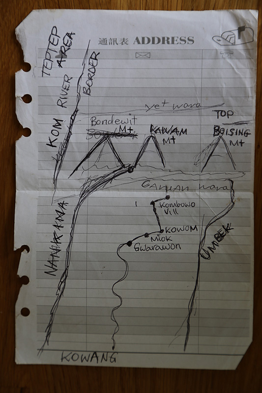
- The first recorded ascendants reported that the local, (Nankina) name consistently is Boising, meaning "Stop the fight". Their GPS measurements on the top were 3751 and 4155 m, while its height is indicated as 4175 m on the 1:100,000 ‘Saidor’ topographic sheet, based on 1973-74 aerial photography. This summit is unnamed on most maps, but is possibly the same as Mount Gladstone, a name bestowed by Hugo Zöller to the highest summit in this range during his expedition through the Finisterre range in 1888. It appeared with this name and a height of just 11,400 feet (c. 3475 m) on the 1942 American Army Map.
- Mount Boising first ascent report.
- Also Mt Salawaket or Mt Saruwaged and Sturmkoppe. Mt Bangeta may alternatively refer to a 4060 m subsidiary peak at 6°16′42″S 147°03′12″E.
- Sometimes reported with an SRTM-data incompatible 4350 m height.
- The height of Antares, always considered the highest mountain of the Sterrengebergte (Star mountains), has been all over the map. The first ascendants underestimated it by some 300 m to be 3650 m while the height of 4170 m on many maps appears 200 m too high. The highest (very narrow) SRTM-contours around the summit are 3940 m.
- The commonly reported height of 4,360 m appears 400 m off target.
- Bondewit and Kawam are local, Nankina names for mountains roughly corresponding to the location of this mountain and ca 3950 m mountain in between it and Mt Boising.
- Name (after the Tiom pass to the south) and height from J. Ehlers, P.L. Gibbard, P.D. Hughes, Quaternary Glaciations - Extent and Chronology: A Closer Look, Elsevier Publishers, Amsterdam 2011, pp. 1026-1031.
- Map in RAP Expedition Kaijende Highlands 2005 report Archived 2011-09-28 at the Wayback Machine.
- MacGregor, William 1899. ‘Despatch reporting visit inland to the western end of the Owen Stanley Range, and thence across the island to the north-east coast.’ Annual Report of British New Guinea 1897-98. Appendix B. Melbourne, Victoria: Government Printer
- Other sources (e.g. Paul W Williams, Arête and Pinnacle Karst of Mount Kaijende, 2009) seem to indicate that the name "Mount Kaijende" belongs to the ca. 3500 m high mountain 10 km to the east at 05°29′40″S 143°17′28″E.
- Many sources give a height of 3834 m for Mt Hagen, but SRTM data show multiple regions on the crater rim with contour lines of 3780 m.
- The 3774 m height is reported for Mount Bedego, which could match the 3700 m contour lines at this location, which more often bears the name Mount Undan or Mount Udon.
- The highest point of the Weyland mountains for many years was held to be 3891 m, but this is not borne out by maximum SRTM-contours of 3720 m.
- A pointy peak which may well be over 3750 m high despite SRTM-contours of only 3700 m.