List_of_old_road_routes_in_Victoria
Road routes in Victoria assist drivers navigating roads throughout the state, as roads may change names several times between destinations, or have a second local name in addition to a primary name. Victoria currently uses two route numbering schemes: the older, numerical shield-based system (which this article focuses on); and a newer, alphanumeric system, slowly replacing the older system.
This article needs additional citations for verification. (May 2014) |
Victoria implemented the federally-issued National Routes system between 1954 and 1955, using white-and-black shields highlighting interstate links between major regional centres; some of these routes were later upgraded into National Highways using green-and-gold shields when the National Roads Act was passed in 1974.
The original route numbering scheme, now known as the Metropolitan Route Numbering Scheme, allocated blue-and-white shields across Melbourne as metropolitan routes, numbered to fit around existing National Routes;[1] this system received a major refurbishment in the late 1980s,[2] with the creation of Tourist Routes as a result. Freeway Routes were spun off from this system between 1970 and 1987, and it was extended into a system covering rural Victoria as the State Route Numbering Scheme in 1985.[3]
The Statewide Route Numbering Scheme, introduced in late 1996,[4] has effectively replaced the previous scheme across regional Victoria, and is progressively replacing routes across Melbourne. It consists of alphanumeric routes, a one-to-three digit number prefixed with a letter (M, A, B, or C) that denotes the grade and importance of the road,[5] and is now the state's default road route numbering system.
Some routes, in part or in their entirety, may have been made obsolete by the alphanumeric designation: these replacement routes are noted but not listed in full here. Some also may follow older alignments or routes later changed even after the new system was introduced, and are included here for the sake of completion. Roads are described in either a west–east or north–south alignment.
For a list of major highways and freeways in Melbourne, see List of highways in Melbourne and List of freeways in Victoria.
National Routes were the first type of route numbering to be attempted in Australia on a large scale, signed with a white shield and black writing (similar in shape to the shield that appears on the Australian coat of arms), with Victoria receiving routes in 1954. They highlighted the interstate links connecting major population, industrial and principal regions of Victoria to the rest of the Australia, in a way that was readily identifiable to interstate travellers. The system was prepared by COSRA (Conference of State Road Authorities), held between 1953 and 1954: once each state road authority agreed to the scheme, it was rolled out federally.
In 1954, the Hume Highway was trialled as National Route 31, chosen due to its prominence as a transport corridor connecting Australia's largest cities (Melbourne and Sydney). Soon after, other National Routes across the state were allocated. Selected routes were later upgraded into National Highways when the National Roads Act was passed in 1974.
Victoria's National Routes were eventually replaced with the Statewide Route Numbering Scheme, introduced in stages across the state beginning in late 1996: each route was converted to an alphanumeric route number, rendering the black-and-white shield redundant. Most National Routes in rural Victoria kept their number during the conversion; an exception was National Route 16, which became B400. Most routes were replaced in 1997 - unless otherwise stated in the table below - with the last of Victoria's routes, National Route 79, finally eliminated in 2013 (although a vestige of Alternative National Route 1 still exists through southeastern Melbourne).
| Route | Component roads | From | Via | To | Length | Notes |
|---|---|---|---|---|---|---|
National Route 1 |
Princes Highway (west) | Vic/SA border | Vic/NSW border | 955 km (593 mi) | Replaced by | |
|
– re-aligned through southeastern Melbourne from Kings Way, St Kilda Road, and Wellington Street to Queens Road/Queens Way when St Kilda Junction reconstruction was completed in 1969 – re-aligned through western Melbourne from Geelong and Ballarat Roads, Smithfield and Racecourse Roads, Flemington Road, Harker and Curzon Streets, King Street (replaced by – re-aligned through South Melbourne from Rogers and Lorimer and Claredon Streets, Market/York Streets to West Gate Freeway when its extension opened in 1988 – re-aligned through southeastern Melbourne from Kings Way, Queens Road/Queens Way, and Princes Highway (replaced by – replaced by | |||||
| CityLink | – re-aligned through Southbank from Sturt/Power Streets, City Road, Alexandra Avenue, Swan Street and Batman Avenue to current alignment when CityLink tunnels opened in 1999 – replaced by | |||||
| South Eastern Freeway | Replaced by | |||||
| South Gippsland Freeway | Replaced by | |||||
| Princes Highway (I) | Replaced by | |||||
| Princes Freeway (east) (I) | Replaced by | |||||
| Princes Highway (II) | Replaced by | |||||
| Princes Freeway (east) (II) | Replaced by | |||||
| Princes Highway (east) | Replaced by | |||||
Alternate National Route 1 |
|
Heywood | Homerton | Tyrendarra | 22 km (14 mi) | Portland bypass route, replaced by: |
|
Brooklyn | Southbank | 17 km (11 mi) | – replaced – replaced by | ||
|
Southbank | Berwick | 50 km (31 mi) | – replaced – eastern end extended along Princes Highway from Eumemmering to Berwick (replacing | ||
National Route 8 |
|
Vic/SA border | Parkville | 440 km (273 mi) | Progressively reallocated along Western Freeway sections as they opened, replaced by | |
National Route 12 |
Mallee Highway | Vic/SA border | Vic/NSW border | 233 km (145 mi) | – eastern end of route extended from Ouyen to Piangil in 1990 – replaced by | |
National Route 16 |
Murray Valley Highway | Vic/NSW border | Vic/NSW border | 663 km (412 mi) | – western end of route re-aligned from Hattah–Robinvale Road terminating in Hattah, to current alignment in late 20th century – replaced by – was partly still mistakenly signed as | |
National Route 20 |
Sturt Highway | Vic/SA border | Mildura | Vic/NSW border | 117 km (73 mi) | Replaced by |
National Route 23 |
Cann Valley Highway | Cann River | Vic/NSW border | 48 km (30 mi) | Replaced by | |
National Route 31 |
Vic/NSW border | Parkville | 301 km (187 mi) | Progressively reallocated along Hume Freeway sections as they opened, replaced by | ||
National Route 39 |
Goulburn Valley Highway | Seymour | Vic/NSW border | 165 km (103 mi) | Replaced by | |
Alternative National Route 39 |
|
Kialla West | Shepparton | Congupna | 19 km (12 mi) | Shepparton bypass route, replaced by |
National Route 75 |
Northern Highway | Wallan | Vic/NSW border | 165 km (103 mi) | – southern end extended from Kilmore to Wallan (along former – replaced by | |
National Route 79 |
Calder Highway | Vic/NSW border | Southbank | 565 km (351 mi) | Replaced by | |
| Calder Freeway | Progressively reallocated along Calder Freeway sections as they opened, replaced by | |||||
| Tullamarine Freeway | – re-aligned between Niddrie and Flemington from Keilor and Mount Alexander roads (replaced by – allocation removed in 2013, not replaced | |||||
|
– southern end of route extended from Parkville through the city to Southbank (along former – replaced by | |||||
Alternate National Route 79 |
Calder Alternative Highway | Marong | Lockwood | Ravenswood | 20 km (12 mi) | Bendigo bypass route, replaced by |
|
Niddrie | Essendon | Flemington | 8 km (5 mi) | Replaced | |
Decommissioned or unsigned route | ||||||
With the passing of the National Roads Act in 1974, selected National Routes were further upgraded to the status of a National Highway: interstate roads linking Australia's capital cities and major regional centres that received federal funding, and were of higher importance than other National Routes. These new routes were symbolised by green shields with gold writing, and the word "National" along the top of the shield. Victoria's first two National Highways, the Western and Hume Highways, were declared in 1974[6] and their shields converted in the following years; the Sturt and Goulburn Valley Highways were declared later in 1992.[7]
Like National Routes, Victoria's National Highways were also replaced with the Statewide Route Numbering Scheme, introduced across the state beginning in late 1996: each route was converted to an alphanumeric route number, all keeping their number during the conversion, but also initially keeping the National green-and-gold shield design; this was eventually eliminated in 2014. While most routes were replaced in 1997, the tail-ends of some routes terminating in suburban Melbourne were kept for some years afterwards, until bypassed or reallocated with the opening of a related road project: these are stated in the table below. The last of Victoria's National Highways, the tail-end of National Highway 8, was finally eliminated in 2009.
| Route | Component roads | From | Via | To | Length | Notes |
|---|---|---|---|---|---|---|
National Highway 8 |
Western Highway | Vic/SA border | Parkville | 440 km (273 mi) | Replaced by | |
| Western Freeway | Progressively reallocated along Western Freeway sections as they opened, replaced by | |||||
| Western Highway | Replaced by | |||||
| Ballarat Road | Replaced by | |||||
|
Allocation removed when Deer Park bypass opened in 2009, not replaced | |||||
National Highway 20 |
Sturt Highway | Vic/SA border | Mildura | Vic/NSW border | 117 km (73 mi) | Replaced by |
National Highway 31 |
Hume Freeway | Vic/NSW border | South Melbourne | 305 km (190 mi) | Progressively reallocated along Hume Freeway sections as they opened, replaced by | |
| Hume Highway | Replaced by | |||||
|
– southern end extended from Parkville to South Melbourne along Peel and Dudley Streets, then along Footscray Road to Montague Street when West Gate Freeway extension opened in 1988 – re-aligned from Footscray Road to current alignment when Wurundjeri Way opened in 1999 – replaced by | |||||
National Highway 39 |
Goulburn Valley Freeway | Seymour | Vic/NSW border | 165 km (103 mi) | Progressively reallocated along Goulburn Valley Freeway sections as they opened, replaced by | |
| Goulburn Valley Highway | Replaced by | |||||
Decommissioned or unsigned route | ||||||
Melbourne
Early in 1964, planning by the Traffic Commission (and consulting with 43 municipal councils and the Country Roads Board),[1] the Metropolitan Route Numbering Scheme – a new route numbering system for the Greater Melbourne area – was unveiled in 1965; Victoria was the first mainland state to adopt this system. The Metropolitan ("Metro") route numbering scheme was symbolised by blue rounded shields with white writing: east–west routes were to be even-numbered, while north–south routes were to be odd-numbered; the numbers allotted to routes were to be complementary to the existing National Routes system;[1] a year later, most of the urban municipalities were either cooperating in the project or had agreed to do so, with 18 having completed or substantially completed the erection of route markers.[8] The scheme had a significant refurbishment during the late 1980s:[2] between 1987 and 1990, many existing routes through Melbourne were modified and new routes were introduced (noted in the table below) to cover new growth areas of Melbourne, involving consultation with over 54 metropolitan municipalities as well as road user groups. A total of 76,000 signs were installed at 1,060 intersections and other locations at a cost of $530,000, with the last signs installed in April 1990.[9]
The most recent change to the system was the introduction of the Statewide Route Numbering System into regional Victoria, beginning in late 1996. While many routes on the outer urban fringes of Melbourne were incorporated into the new alphanumeric system (some only introduced less than 10 years earlier), the majority of the system across suburban Melbourne still survives to the current day. While some metropolitan routes are still being allocated (like ![]() in 2016), the expectation is their eventual replacement in the near-future by the new alphanumeric system, with a small number of routes currently undergoing conversion.
in 2016), the expectation is their eventual replacement in the near-future by the new alphanumeric system, with a small number of routes currently undergoing conversion.
| Route | Component roads | From | Via | To | Length | Notes |
|---|---|---|---|---|---|---|
Metro Route 2 |
|
Docklands | Eaglemont | 32 km (20 mi) | – northern end extended along Montague Street and Footscray Road when Charles Grimes Bridge opened in 1978 – replaced by | |
Metro Route 3 |
Melbourne | Mornington | 51.8 km (32 mi) | – northern end along Swanston and Elizabeth streets terminating in Parkville truncated to current alignment in 1989 – concurrencies with: | ||
| Mornington | Point Nepean | 42.1 km (26 mi) | Replaced by | |||
| Removed from Sorrento to Point Nepean in 1998 | ||||||
Metro Route 4 |
Cranbourne–Frankston Road | Frankston | Cranbourne | 17 km (11 mi) | – allocated in 1989 – eastern end along Pattersons Road terminating in Clyde replaced by | |
Metro Route 5 |
|
Croydon | Lysterfield | 19 km (12 mi) | – allocated in 1989 – concurrency with | |
Metro Route 6 |
Carrum | Clyde North | 19 km (12 mi) | Allocated in 1989 | ||
Metro Route 7 |
|
Warrandyte South | Knoxfield | 18 km (11 mi) | Allocated in 1989 | |
Metro Route 8 |
Ballarat Road | Caroline Springs | Footscray | 21 km (13 mi) | Allocated when Deer Park bypass opened in 2009, replacing | |
Metro Route 9 |
|
Wattle Glen | Frankston | 63 km (39 mi) | – southern end re-aligned through Frankston from Dandenong Road East and Beach Street to current alignment in 1991 when Beach Street rail crossing closed – concurrencies with: | |
Metro Route 10 |
|
Black Rock | Dandenong | 18 km (11 mi) | Concurrency with | |
Metro Route 11 |
Mornington Peninsula Freeway (I) | Chelsea Heights | Rosebud | 51 km (32 mi) | – northern end via Springvale Road terminating in Donvale truncated to current alignment (replaced by – progressively re-aligned from Wells Road as sections of the Mornington Peninsula Freeway opened through the late 1970s – replaced by | |
| Frankston Freeway | – progressively re-aligned from Wells Road as sections of the Frankston Freeway (initially called Wells Road By-pass) opened through the early 1970s – replaced by | |||||
| Moorooduc Highway | – southern end extended along Moorooduc Highway and Mornington Peninsula Freeway from Frankston South to Rosebud (replacing – replaced by: | |||||
| Mornington Peninsula Freeway (II) | – re-aligned from (Old) Moorooduc Road to Mornington Peninsula Freeway when eastern extension opened (from Mount Martha to Moorooduc) in 1994 – replaced by | |||||
Metro Route 12 |
|
Mordialloc | Narre Warren | 19 km (12 mi) | Allocated in 1989 | |
Metro Route 13 |
|
Doncaster East | Clayton | 20 km (12 mi) | Northern end re-aligned through Doncaster East from Blackburn Road to current alignment in 1989 | |
Metro Route 14 |
|
Brighton | Narre Warren North | 34 km (21 mi) | – eastern end extended along Kingston and Heatherton Roads from Heatherton to Harkaway in 1989 – re-aligned through Heatherton from Warrigal and Heatherton Roads when Dingley Bypass opened in 2016 – concurrency with | |
Metro Route 15 |
Warrigal Road | Surrey Hills | Parkdale | 19 km (12 mi) | ||
Metro Route 16 |
|
Brighton East | Mulgrave | 17 km (11 mi) | – allocated in 1989 – eastern end extended along Police Road through Mulgrave when EastLink opened in 2008 | |
Metro Route 17 |
|
Eaglemont | Moorabbin | 18 km (11 mi) | Concurrencies with: | |
Metro Route 18 |
|
Brighton | Rowville | 21 km (13 mi) | – eastern end extended along Wellington Road from Lysterfield to Clematis in 1989 – replaced along Wellington Road from Rowville to Clematis by | |
Metro Route 19 |
|
Kew | Black Rock | 19 km (12 mi) | Concurrency with | |
Metro Route 20 |
|
South Melbourne | Box Hill South | 16 km (10 mi) | – allocated in 1989 – western end along Montague Street and Footscray Road terminating in Docklands truncated to current alignment when Wurundjeri Way opened in 1999 – concurrency with | |
Metro Route 21 |
|
Reservoir | Toorak | 17 km (11 mi) | – northern end extended from Alphington to Reservoir in 1989 – concurrency with | |
Metro Route 22 |
|
Balaclava | Upper Ferntree Gully | 31 km (19 mi) | – western end extended along Neerim and Glen Eria Roads in 1989 – replaced along Mount Dandenong Tourist Road from Upper Ferntree Gully to Montrose by – concurrencies with: | |
Metro Route 23 |
Doncaster East | Aspendale Gardens | 26 km (16 mi) | Allocated in 1989 | ||
Metro Route 24 |
|
Windsor | Knoxfield | 24 km (15 mi) | Western end extended along Lorne Street in 1989 | |
Metro Route 25 |
|
Burnley | Hampton | 12 km (7 mi) | ||
Metro Route 26 |
|
Albert Park | Upper Ferntree Gully | 34 km (21 mi) | – western end along Howe Parade, Beach Street and Beaconsfield Parade truncated to current alignment in 1989 – eastern end extended from Belgrave to Emerald along Belgrave-Gembrook Road in 1989 – replaced along Burwood Highway and Belgrave–Gembrook Road from Upper Ferntree Gully to Emerald by – concurrency with | |
Metro Route 27 |
Plenty Road | Bundoora | Kingsbury | Preston | 9.7 km (6 mi) | – northern end extended along Plenty Road from South Morang to Whittlesea in 1989 – northern end truncated back to South Morang, replaced by – northern end truncated further to Bundoora, replaced by |
Metro Route 28 |
Mountain Highway | Vermont South | Sassafras | 18 km (11 mi) | ||
Metro Route 29 |
|
Epping | Elwood | 28 km (17 mi) | Concurrency with | |
Metro Route 30 |
|
Port Melbourne | Camberwell | 16 km (10 mi) | – re-aligned through central Melbourne from Flinders and Spencer Streets and Normanby Road to Flinders Street (extension), North Wharf Road, Johnson and Montague Streets and Normanby Road when Charles Grimes Bridge opened in 1978 – western end re-aligned from Johnson and Montague Streets, Normanby and Williamstown Roads, Yarra River crossing, Douglas Parade and Kororoit Creek Road terminating in Laverton North (replaced by – western end truncated to terminate at North Wharf Road when West Gate Freeway extension to Montague Street opened in 1985 – western end extended to Port Melbourne in 1989 – re-aligned through central Melbourne along Wurundjeri Way when it opened in 1999 – concurrency with | |
Metro Route 32 |
|
Derrimut | Montrose | 53 km (33 mi) | – western end re-aligned from Somerville Road and Whitehall Street terminating in Yarraville (replaced by – re-aligned through central Melbourne previously along Adderley and LaTrobe Streets to current alignment in 1989 – replaced along Swansea Road and Anderson Street from Montrose to Lilydale by – concurrencies with: | |
Metro Route 33 |
|
Port Melbourne | Mordialloc | 29 km (18 mi) | – northern end re-aligned from Spencer and Claredon Streets, City Road, Crockford and Bay Streets terminating in West Melbourne to current alignment in 1989 – concurrency with | |
Metro Route 34 |
|
Carlton | Lilydale | 38.1 km (24 mi) | – eastern end extended along Maroondah Highway from Lilydale to Alexandra in 1986 – western end along Gatehouse Street and College Crescent truncated to current alignment in 1989 – eastern end truncated back to Lilydale, replaced by | |
Metro Route 35 |
|
Somerton | Laverton North | 40 km (25 mi) | – southern end extended along Douglas Parade and Kororoit Creek Road from Spotswood to Laverton North (replacing – northern end re-aligned from Barry Road terminating in Campbellfield to current alignment in 1989 – re-aligned through Footscray from Cowper and Bunbury and Hyde Streets to current alignment in 1989 – concurrencies with: | |
Metro Route 36 |
|
Hawthorn | The Basin | 33 km (21 mi) | Concurrencies with: | |
Metro Route 37 |
|
Essendon North | Williamstown | 16 km (10 mi) | – northern end extended from Essendon to Essendon North along Bulla Road (replacing – concurrency with | |
Metro Route 38 |
|
Sunshine | Fairfield | 19 km (12 mi) | – western end extended from Sunshine to Maidstone in 1989 – concurrencies with: | |
Metro Route 39 |
|
Greenvale | Altona | 37 km (23 mi) | – allocated in 1989 – replaced along Mickleham Road from Yuroke to Greenvale by – concurrencies with: | |
Metro Route 40 |
|
Laverton North | Keilor | 20 km (12 mi) | – western end re-aligned from Lancefield and Bulla Roads, Woodland Street, Reynolds Parade to Bell Street terminating in Bulla to Tullamarine Bypass Road when it opened in 1968 – re-aligned through Pascoe Vale South from Lancefield and Bulla Roads, Woodland Street and Reynolds Parade to Tullamarine Freeway when it opened in 1970 – re-aligned through Airport West from Lancefield Road to Tullamarine Freeway when last stage converted in 1979 – western end re-aligned from Sunbury Road and Tullamarine Freeway terminating in Bulla (replaced by | |
| Keilor | Airport West | Strathmore | 9.8 km (6 mi) | Removed in 2020, route split into two sections | ||
| Pascoe Vale South | Edithvale | 52 km (32 mi) | – eastern end re-aligned from Station Street and Huntingdale Road (replaced by – southern end extended from Doncaster to Edithvale (replacing – concurrencies with: | |||
Metro Route 41 |
|
Keilor North | Altona Meadows | 30 km (19 mi) | Northern end re-aligned from Green Gully Road, Arthur Street and St Albans Road terminating in Keilor to current alignment in 1989 | |
Metro Route 42 |
|
Balwyn North | Wonga Park | 27 km (17 mi) | – re-aligned through Templestowe from Parker and Anderson Streets (replaced by – eastern end extended to Wonga Park via Jumping Creek Road in 1989 – concurrencies with: | |
Metro Route 43 |
|
Sunbury | Port Melbourne | 44 km (27 mi) | – allocated from Sunbury to Melbourne Airport (replacing – replaced by: | |
| Tullamarine Freeway | – allocated from Melbourne Airport to Essendon Airport (replacing – southern end extended to Port Melbourne when CityLink (Western link) opened in 1999 – | |||||
| CityLink (Western link) | Allocated in 1999 when CityLink (Western link) opened, toll road, | |||||
Metro Route 44 |
|
Ivanhoe | Kangaroo Ground | 22 km (14 mi) | Concurrency with | |
Metro Route 45 |
|
Reservoir | Collingwood | 11 km (7 mi) | – allocated in 1989 – concurrency with | |
Metro Route 46 |
|
Hurstbridge | East Melbourne | 28 km (17 mi) | – southern end along Exhibition Street to central Melbourne truncated to current alignment in 1989 – re-aligned through Greensborough from Grimshaw Street and Diamond Creek Road to current alignment in 1989 – concurrencies with: | |
Metro Route 47 |
|
Templestowe | Huntingdale | 18 km (11 mi) | – allocated in 1989, replaced: – replaced along Fitzsimons Lane and Williamsons Road from Templestowe to Eltham by – concurrencies with: | |
Metro Route 48 |
|
Gladstone Park | Eltham | 29 km (18 mi) | – eastern end along Main Road, Fitzsimons Lane and Williamsons Road terminating in Doncaster truncated to current alignment (replaced by – re-aligned through Thomastown from High Street and Settlement Road to current alignment in 1989 | |
Metro Route 49 |
Clayton | Keysborough | Dandenong South | 15 km (9 mi) | – allocated in 1989 – extended south to Keysborough when extension opened in 1995, extended north to Clayton when extension opened in 2001 – eastern end extended along Dandenong Bypass when its second stage opened in 2012 | |
Metro Route 50 |
|
Yarraville | Southbank | 10 km (6 mi) | – allocated in 1989 – concurrency with | |
Metro Route 52 |
|
Bulleen | Templestowe | Donvale | 15 km (9 mi) | – allocated in 1989 – concurrency with |
Metro Route 54 |
Keilor–Melton Road | Melton | Sydenham | Keilor | 18 km (11 mi) | Allocated in 1989, replaced by |
Metro Route 55 |
|
Craigieburn | South Melbourne | 34 km (21 mi) | – allocated when the Craigieburn bypass opened in 2005, replacing – concurrency with | |
Metro Route 56 |
Blackshaws Road | Altona North | Newport | 5.0 km (3 mi) | – allocated in 1989 – replaced along Dohertys Road from Laverton North to Altona North by | |
Metro Route 57 |
|
Mernda | Diamond Creek | Eltham | 19 km (12 mi) | – allocated in 1989 – concurrency with |
Metro Route 58 |
|
Bulla | Yarrambat | 28 km (17 mi) | – allocated in 1989 – concurrency with: | |
Metro Route 60 |
|
Frankston South | Devon Meadows | 19 km (12 mi) | Allocated in 1989, replaced by | |
|
Parkville | West Melbourne | Southbank | 6 km (4 mi) | Reallocated in 2013, replaced southern end of | |
Metro Route 61 |
|
Narre Warren East | Harkaway | Berwick | 10.6 km (7 mi) | – allocated in 1989 – southern end along Clyde and Berwick–Cranbourne and Clyde-Fiveways Road terminating in Five Ways truncated to current alignment in 1998 – replaced by: |
Metro Route 62 |
|
Mornington | Moorooduc | Tyabb | 13 km (8 mi) | Allocated in 1989, replaced by |
|
Ringwood | Croydon | Montrose | 12 km (7 mi) | Reallocated in 2008, replaces eastern end of | |
Metro Route 63 |
|
Lilydale | Cranbourne | 52 km (32 mi) | Allocated in 1989, replaced by | |
Metro Route 64 |
Bittern-Dromana Road | Dromana | Merricks North | Bittern | 15 km (9 mi) | Allocated in 1989, replaced by |
Metro Route 65 |
South Gippsland Freeway | Doveton | Hastings | 31 km (19 mi) | Allocated in 1989, replaced by | |
| Dandenong-Hastings Road | Allocated in 1989, replaced by: | |||||
Metro Route 67 |
|
Frankston | Rosebud | 70 km (43 mi) | Allocated in 1989, replaced by: | |
Metro Route 69 |
Balnarring Road | Tuerong | Merricks North | Balnarring | 11 km (7 mi) | Allocated in 1989, replaced by |
Metro Route 71 |
Mornington–Flinders Road | Dromana | Main Ridge | Flinders | 20 km (12 mi) | Allocated in 1989, replaced by |
| Cook Street | Allocated in 1989, replaced by | |||||
Metro Route 73 |
Coolart Road | Baxter | Bittern | Balnarring | 18 km (11 mi) | Allocated in 1989, replaced by |
Metro Route 77 |
Kings Road | Keilor North | Taylors Lakes | Delahey | 5 km (3 mi) | Allocated in 2015 |
Metro Route 80 |
South Eastern Freeway | Richmond | Burnley | 2.9 km (2 mi) | Replaced by | |
| Altona North | Greensborough | 38 km (24 mi) | – allocated when first section opened in 1992; some – replaced by | |||
Metro Route 83 |
|
Altona North | Clifton Hill | 18 km (11 mi) | – allocated in 1989, replacing – eastern end extended from Balwyn North to Donvale when Eastern Freeway extension opened in 1997 – eastern end along Eastern Freeway terminating in Donvale truncated to current alignment, replaced by – concurrencies with: | |
Metro Route 87 |
Dingley Bypass | Oakleigh South | Springvale South | 6 km (4 mi) | – allocated when Dingley Bypass opened in 2016 – concurrency with | |
Decommissioned or unsigned route | ||||||
Rural Victoria
After the success of the Metropolitan Route Numbering Scheme across the Greater Melbourne area, an extension of the system was rolled out across regional Victoria from late 1985 as the State Route Numbering System; the South Gippsland Highway was the first road in Victoria signed with a State Route,[3] with others following through 1986[3] and 1987,[2] at an estimated cost of $400,000.[10] The designated routes were considered major significant intra-state and regional links that weren't already National Routes. The allocation of State Routes occurred with lower numbers in western Victoria gradually increasing in a clockwise direction to eastern Victoria. Like their suburban Melbourne counterparts, east–west routes were to be even-numbered, while north–south routes were to be odd-numbered, with reservations between 91–99 for the Greater Geelong area, and 100–199 for all of rural Victoria.[10]
The system lasted just over a decade, before the Statewide Route Numbering Scheme was first introduced in north–eastern Victoria in late 1996. Most State Routes were converted into the alphanumeric system by 1998, with the rest completed by 2000; none now exist.
| Route | Component roads | From | Via | To | Length | Notes |
|---|---|---|---|---|---|---|
State Route 91 |
Ryrie Street | Geelong | Queenscliff | 31 km (19 mi) | Replaced by | |
| Sydney Parade | Unallocated, not replaced | |||||
|
Replaced by | |||||
State Route 100 |
Belmont | Allansford | 255 km (158 mi) | Replaced by | ||
State Route 104 |
Hopkins Highway | Warrnambool | Ellerslie | Mortlake | 50 km (31 mi) | – allocated when highway declared in 1990 – replaced by |
State Route 106 |
Hamilton Highway | Hamilton | Geelong | 231 km (144 mi) | Replaced by | |
State Route 107 |
Henty Highway | Lascelles | Portland | 231 km (144 mi) | Replaced by: | |
State Route 111 |
Grampians Road | Stawell | Halls Gap | Dunkeld | 90 km (56 mi) | Replaced by |
State Route 112 |
Glenelg Highway | Vic/SA border | Ballarat | 289 km (180 mi) | Replaced by | |
State Route 121 |
Sunraysia Highway | Ouyen | Ballarat | 344 km (214 mi) | Replaced by | |
State Route 122 |
Pyrenees Highway | Ararat | Elphinstone | 149 km (93 mi) | Replaced by | |
State Route 124 |
|
Bungalally | Ararat | 94 km (58 mi) | Replaced by | |
State Route 130 |
Wimmera Highway | Vic/SA border | St Arnaud | 238 km (148 mi) | Replaced by | |
State Route 138 |
Borung Highway | Dimboola | Charlton | 133 km (83 mi) | Replaced by: | |
State Route 141 |
Loddon Valley Highway | Kerang | Heathcote | 176 km (109 mi) | Replaced by | |
| McIvor Highway | Replaced by | |||||
State Route 148 |
Hattah–Robinvale Road | Hattah | Wemen | Lake Powell | 62 km (39 mi) | – allocated when road declared in 1990 – replaced by |
State Route 149 |
Midland Highway | Geelong | Benalla | 400 km (249 mi) | Replaced by | |
State Route 153 |
Benalla |
|
Coldstream | 181 km (112 mi) | Replaced by | |
Alternative State Route 153 |
Midland Highway | Barjang | Mansfield | Maindample | 26.7 km (17 mi) | Replaced by |
| Maroondah Highway | Replaced by | |||||
State Route 154 |
|
Tarrawingee | Beechworth | Wodonga | 61 km (38 mi) | Replaced by |
State Route 156 |
|
Wangaratta | Omeo | 185 km (115 mi) | Replaced by | |
State Route 160 |
Glenrowan–Myrtleford Road | Glenrowan | Myrtleford | Running Creek | 88 km (55 mi) | Replaced by |
|
Replaced by | |||||
State Route 164 |
Mount Buller Road | Mansfield | Merrijig | Mount Buller | 58 km (36 mi) | Replaced by |
State Route 168 |
Goulburn Valley Highway | Seymour | Eildon | 106 km (66 mi) | Replaced by | |
State Route 172 |
|
Narbethong | Marysville | Lake Mountain | 30 km (19 mi) | Replaced by |
State Route 173 |
Taggerty-Thornton Road | Taggerty | Thornton | 12 km (7 mi) | Replaced by | |
State Route 174 |
Warburton Highway | Lilydale | Warburton | 75 km (47 mi) | Replaced by | |
State Route 175 |
Healesville–Kinglake Road | Castella | Korumburra | 169 km (105 mi) | Replaced by | |
| Healesville–Koo Wee Rup Road | Replaced by | |||||
| Dalry Road | Unallocated, not replaced | |||||
| Don Road | Replaced by | |||||
| Yarra Junction–Noojee Road | Replaced by | |||||
| Main Neerim Road | Replaced by: | |||||
| Drouin–Warragul Road | Replaced by | |||||
| Drouin–Korumburra Road | Replaced by: | |||||
| Warragul-Korumburra Road | Replaced by | |||||
State Route 176 |
Donna Buang Summit Road | Mount Donna Buang | Warburton | 18 km (11 mi) | Unallocated, not replaced | |
| Donna Buang Road | Replaced by | |||||
| Acheron Way | Replaced by | |||||
State Route 180 |
South Gippsland Highway | Dandenong | Sale | 258 km (160 mi) | – allocated December 1985, the first road in Victoria to be signed with a State Route[3] – replaced by: | |
State Route 181 |
Bass Highway | Lang Lang | Leongatha | 87 km (54 mi) | – extended from Inverloch to Leongatha in 1990 – replaced by: – a faded | |
State Route 182 |
Strzelecki Highway | Leongatha | Mirboo North | Morwell | 56 km (35 mi) | – allocated when highway declared in 1990 – replaced by |
State Route 186 |
Phillip Island Road | Anderson | Newhaven | Cowes | 23 km (14 mi) | Replaced by |
State Route 188 |
Hyland Highway | Traralgon | Gormandale | Yarram | 56 km (35 mi) | – allocated when highway declared in 1990 – replaced by |
State Route 189 |
|
Meeniyan | Fish Creek | Wilsons Promontory | 72 km (45 mi) | Replaced by |
State Route 190 |
Monash Way | Morwell | Port Welshpool | 88 km (55 mi) | Replaced by | |
|
Unallocated, not replaced | |||||
| Welshpool Road | Replaced by | |||||
State Route 191 |
|
Bandiana | Glen Valley | 151 km (94 mi) | Replaced by | |
State Route 195 |
Omeo Highway | Tallangatta | Bairnsdale | 285 km (177 mi) | Replaced by: | |
State Route 199 |
Bonang Road | Vic/NSW border | Goongerah | Orbost | 114 km (71 mi) | Replaced by |
Decommissioned or unsigned route | ||||||
After the success of the Metropolitan Route Numbering Scheme across the Greater Melbourne area, a new route number system specifically for suburban freeways was rolled out in 1970, following the opening of the first section of the Tullamarine Freeway. Freeway Routes were symbolised by green rounded shields with white writing, with route numbers prefixed by the letter F. They were the first type of route numbering in Victoria based solely on road classification alone, providing a clear separation to other route numbering systems across Melbourne. Route numbers were adapted from the Metropolitan Route Numbering System, with numbers 80 to 90 exclusively reserved for Freeway Routes.
The system was decommissioned between 1987 and 1990: routes were either replaced by a metropolitan route or a National Route number, or simply removed if allocations already existed concurrent to the Freeway Route. Some of these route numbers have been subsequently reallocated as metropolitan routes across Melbourne (like ![]() and
and ![]() ).
).
| Route | Component roads | From | Via | To | Length | Notes |
|---|---|---|---|---|---|---|
Freeway Route 80 |
South Eastern Freeway | Richmond | Burnley | Kooyong | 9 km (6 mi) | Replaced |
Freeway Route 81 |
Tullamarine Freeway | Melbourne Airport | Flemington | 18 km (11 mi) | Replaced by: – – removed from Essendon Airport to Flemington in 1989 (later replaced by | |
| Chadstone | Lyndhurst | 25 km (16 mi) | – western end progressively extended as sections opened eventually to Chadstone in 1981 – replaced by: | |||
Freeway Route 82 |
West Gate Freeway | Brooklyn | Spotswood | South Melbourne | 12 km (7 mi) | – eastern end progressively extended as sections opened eventually to South Melbourne in 1986 – removed in 1987 |
Freeway Route 83 |
Eastern Freeway | Clifton Hill | Bulleen | Balwyn North | 11 km (7 mi) | – eastern end extended when section opened to Balwyn North in 1982 – replaced by |
Freeway Route 87 |
Mornington Peninsula Freeway | Safety Beach | Dromana | Rosebud | 9 km (6 mi) | – southern end extended when section opened to Rosebud in 1975 – replaced by |
Freeway Route 90 |
Calder Freeway | Taylors Lakes | Keilor | Niddrie | 9 km (6 mi) | – western end progressively extended as sections opened eventually to Taylors Lakes in 1984 – removed in 1987 |
Decommissioned or unsigned route | ||||||
| Route | Component roads | From | Via | To | Length | Notes |
|---|---|---|---|---|---|---|
Ring Road 80 |
Western Ring Road | Tullamarine | Gladstone Park | Jacana | 2.8 km (2 mi) | Allocated when first section opened; quickly replaced by |
Decommissioned or unsigned route | ||||||
As part of the major refurbishment of the Metropolitan Route Numbering Scheme in the late 1980s, one of Melbourne's more-scenic metropolitan routes was converted into the state's first Tourist Route in 1989,[11] a route specifically marked as being suited for visiting tourists or linking to particular tourist attractions. Tourist Routes are symbolised by a five-sided shield and coloured brown to stand out from existing routes, and were untouched by the introduction of the Statewide Route Numbering System in late 1996.
| Route | Component roads | From | Via | To | Length | Notes |
|---|---|---|---|---|---|---|
Tourist Drive 2 Yarra Scenic Drive |
|
Williamstown | Warrandyte | 60 km (37 mi) | – replaced – decommissioned between Williamstown and Melbourne CBD; route now starts at the – replaced by | |
Tourist Drive 2 [13] |
|
Bairnsdale | ||||
Tourist Drive 3 [14] |
|
|
||||
Tourist Drive 5 Tulloch Ard [15] |
|
Buchan | ||||
Tourist Drive 6 Raymond Creek Falls Tourist Drive [16] |
|
42 km (26 mi) | ||||
Tourist Drive 7 Lakeside & Coastal Tourist Drive |
|
Genoa | Mallacoota | 22 km (14 mi) | ||
Tourist Drive 11 Bay West Trail [12] |
|
Werribee | Spotswood | 55 km (34 mi) | – mostly unsigned – replaced | |
Tourist Drive 12 Frankston Cultural Drive |
|
10 km (6 mi) | Route is entirely a loop | |||
Tourist Drive 13 Winery Tour [17][18][19] |
|
Melton | Route is entirely a loop | |||
Tourist Drive 14 [17][18][19] |
Route has multiple branches | |||||
Tourist Drive 21 [17][19] |
|
Melbourne |
|
750 km (466 mi) | – Route is entirely a loop – Route coincides with Great Southern Touring Route | |
Tourist Drive 22 Otways Waterfalls & Forest Drive |
|
Lorne |
|
Route is entirely a loop | ||
Tourist Drive 31 Grampians Scenic Drive |
Ararat–Halls Gap Road | Halls Gap | Ararat | 44 km (27 mi) | ||
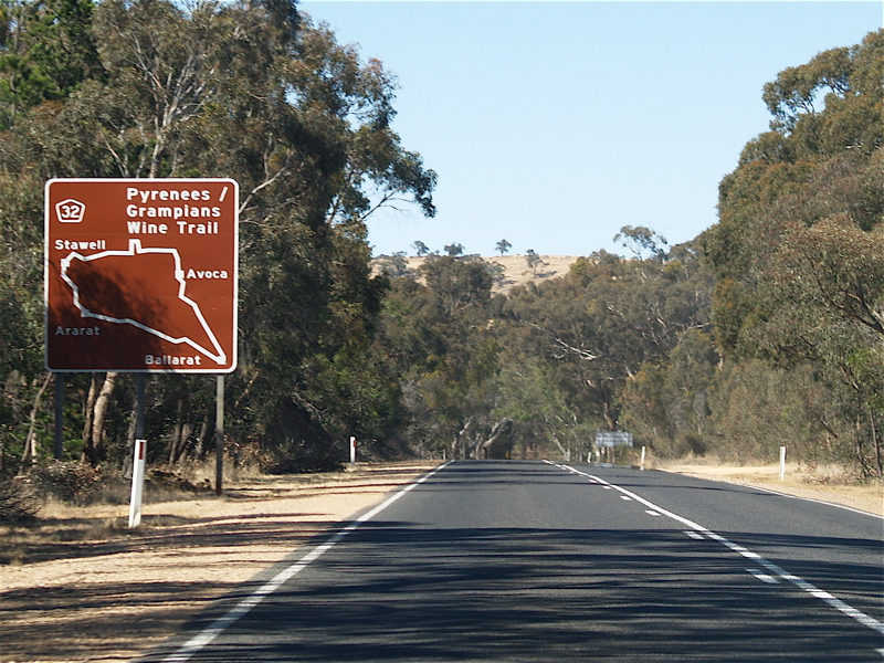
Tourist Drive 32 Pyrenees / Grampians Wine Trail [20] |
Ballarat | Route is entirely a loop | ||||
Tourist Drive 41 [21][22] |
|
Castlemaine | ||||
Tourist Drive 42 [21][23] |
|
Castlemaine | Maldon | |||
Tourist Drive 43 [21][24] |
|
Maldon | Route has many branches around the Maldon area. | |||
Tourist Drive 44 Fossickers Drive |
|
Wedderburn | Route is entirely a loop | |||
Tourist Drive 51 Lake Boga District Drive [25] |
|
Lake Boga | Tresco West | Tresco | 16.7 km (10.4 mi) | |
Tourist Drive 52 Rural District Drive [26][27] |
|
Swan Hill | Swan Hill | 44 km (27 mi) | ||
Tourist Drive 53 Mallee Parks Scenic Route [28] |
|
Hattah | Hattah-Kulkyne National Park | Carwarp | 51.7 km (32.1 mi) | |
Tourist Drive 54 Red Cliffs Tourist Drive [29] |
|
Red Cliffs | 12.5 km (7.8 mi) | Route starts and terminates in Red Cliffs | ||
Tourist Drive 61 Rushworth Hidden Treasures Tourist Drive |
|
Nagambie | Echuca | 117 km (73 mi) | ||
Tourist Drive 62 Gunbower Island Tourist Drive |
|
Gunbower | Cohuna | |||
Tourist Drive 63 Living Heritage Tourist Drive |
|
Rochester | Echuca | |||
Tourist Drive 64 Winery Trail |
|
Seymour |
|
Seymour | Route is a loop | |
Tourist Drive 65 Military Heritage Drive |
|
Seymour |
|
Murchison | ||
Tourist Drive 67 Gold and Ironbark Trail |
|
Toolleen |
|
Rushworth | ||
Tourist Drive 81 Snowy River Country Trail [30] |
|
Orbost |
|
Orbost | ||
Tourist Drive 91 Walhalla & Mountain Rivers Trail [31] |
|
Moe | Traralgon | Route branches off by Walhalla Road to Walhalla Township
Route formally extended to Cowwarr, with a branching from Toongabbie, looping to Cowwarr Weir | ||
Tourist Drive 92 Bunurong Coastal Drive |
|
Kilcunda | Inverloch | |||
Tourist Drive 93 Grand Ridge Road |
|
Seaview |
|
Carrajung | 132 km (82 mi) | |
Tourist Drive 94 Strzelecki Trail [32] |
|
Traralgon |
|
Route is entirely a loop | ||
Tourist Drive 95 Tarra Bulga Trail |
|
Welshpool |
|
Yarram | ||
Tourist Drive 96 Ninety Mile Beach |
|
Longford |
|
Woodside Beach | ||
Tourist Drive 97 Cape Liptrap Trail |
|
Tarwin Lower | Walkerville | Fish Creek | Route is not signed from Fish Creek junction to Walkerville | |
Tourist Drive 98 Power Drive [33] |
|
Traralgon | Morwell |
- "Country Roads Board Victoria. Fifty-Second Annual Report: for the year ended 30 June 1965". Country Roads Board of Victoria. Melbourne: Victorian Government Library Service. 2 December 1965. p. 48.
- "Road Construction Authority of Victoria. Annual Report for the year ended 30 June 1987". Road Construction Authority. Melbourne: Victorian Government Library Service. 30 September 1987. p. 59.
- "Road Construction Authority of Victoria. Annual Report for the year ended 30 June 1986". Road Construction Authority. Melbourne: Victorian Government Library Service. 24 November 1986. pp. 30, 42.
- "VicRoads Annual Report 1996-97". VicRoads. Melbourne: Victorian Government Library Service. 27 August 1997. p. 24.
- VicRoads (2001). "Direction Signs and Route Numbering (non-Freeway)" (PDF). Traffic Engineering Manual, Chapter 2 - Edition 1. Government of Victoria. pp. 21–35. Archived from the original (PDF) on 6 April 2016. Retrieved 10 May 2014.
- "Country Roads Board Victoria. Sixty-Second Annual Report: for the year ended 30 June 1975". Country Roads Board. Melbourne: Victorian Government Library Service. 3 November 1975. p. 26.
- "VicRoads Annual Report 1992-93". VicRoads. Melbourne: Victorian Government Library Service. 29 September 1993. p. 45.
- "Country Roads Board Victoria. Fifty-Third Annual Report: for the year ended 30 June 1966". Country Roads Board of Victoria. Melbourne: Victorian Government Library Service. 4 February 1967. p. 79.
- "VicRoads Annual Report 1989-90". VicRoads. Melbourne: Victorian Government Library Service. 18 October 1990. p. 55.
- "Road Construction Authority of Victoria. Annual Report for the year ended 30 June 1988". Road Construction Authority. Melbourne: Victorian Government Library Service. 24 September 1988. p. 21.
- "Road Construction Authority of Victoria. Annual Report for the year ended 30 June 1989". Road Construction Authority of Victoria. Melbourne: Victorian Government Library Service. 24 September 1989. pp. 20–1.
- Melway Publishing (June 2023). "Greater Melbourne Street Directory" (Map). Melway (50 ed.). 1:20,000. Melbourne street directories. Greater Melbourne: Melway Publishing. ISBN 978-0-909439-84-2.
- "A1 Bairnsdale, Junction to Payneville Road". Google Maps. Retrieved 29 August 2023.
- Rands, Paul. "Corner of Gt Alpine Rd (B500) and Swan Reach Rd at Mossiface, May 2011". Expressway. Retrieved 19 August 2023.
- "Basin Road". Google Maps. Retrieved 20 August 2023.
- Google (May 2023). "2 Nicholson St, Orbost, Victoria". Google Street View. Google. Retrieved 20 August 2023.
- Meridian Maps (2007). Victoria Touring Map (Paper map) (1st ed.). 1:900,000. State Maps. Victoria: Meridian Maps. ISBN 9-781920-958060.
- Meridian Maps (2021). Wombat State Forest 4WD Map (Paper map) (5th ed.). 1:50,000. 4WD & Touring Maps. Victoria: Meridian Maps. ISBN 9-781920-958404.
- Universal Publishers (2010). Melbourne Street Directory 2011 (Map) (45th ed.). 1:20,000. Melbourne Street Directories. Greater Melbourne: Universal Publishers. ISBN 9-780731-925643.
- Tilley, Rob. "Sign at Ararat showing TD32, December 2006". Expressway. Retrieved 19 August 2023.
- Tourism Victoria. "Mount Alexander Diggings Trail". Archived from the original on 14 July 2005. Retrieved 21 August 2023 – via Visit Victoria.
- Google (March 2010). "25 B180, Castlemaine, Victoria". Google Street View. Google. Retrieved 21 August 2023.
- Google (March 2010). "91 C283, Maldon, Victoria". Google Street View. Google. Retrieved 21 August 2023.
- Google (March 2010). "17 High St, Maldon, Victoria". Google Street View. Google. Retrieved 21 August 2023.
- Google (February 2010). "43 Ridge Rd, Lake Boga, Victoria". Google Street View. Google. Retrieved 22 August 2023.
- Swan Hill Rural City Council. "Swan Hill Region Touring Guide" (PDF). Swan Hill Online. Swan Hill. p. 2. Archived from the original (PDF) on 26 September 2009. Retrieved 22 August 2023 – via Swan Hill Online.
- Google (June 2023). "Woorinen Rd, Swan Hill, Victoria". Google Street View. Google. Retrieved 22 August 2023.
- Google (October 2022). "Boonoonar Rd, Carwarp, Victoria". Google Street View. Google. Retrieved 22 August 2023.
- Google (May 2018). "47 Jacaranda St, Red Cliffs, Victoria". Google Street View. Google. Retrieved 22 August 2023.
- Lakes & Wilderness Tourism Association (March 2001). Snowy River Country Trail (PDF) (Map). Snowy River Country. p. 1. Archived from the original on 13 October 2009. Retrieved 20 August 2023.
{{cite map}}: CS1 maint: unfit URL (link) - "Walhalla & Mountain Rivers Drive Brochure" (PDF). Visit Latrobe Valley. 18 January 2022. Retrieved 20 January 2022.
- "Strzelecki Drive Route 94 Brochure" (PDF). Visit Latrobe City. 10 June 2019. Retrieved 20 January 2022.
- "Power Drive Route 98 Brochure" (PDF). Visit Latrobe Valley. 10 February 2020. Retrieved 20 January 2022.