PR-143
Puerto Rico Highway 143
Highway in Puerto Rico
Puerto Rico Highway 143 (PR-143) is a secondary highway that connects the town of Adjuntas to the town of Barranquitas.
| Ruta 143 | ||||
| Route information | ||||
| Maintained by Puerto Rico DTPW | ||||
| Length | 58.7 km[1][2][3] (36.5 mi) | |||
| Existed | 1953[4]–present | |||
| Major junctions | ||||
| West end | ||||
| Major intersections |
| |||
| East end | ||||
| Location | ||||
| Country | United States | |||
| Territory | Puerto Rico | |||
| Municipalities | Adjuntas, Utuado, Ponce, Jayuya, Juana Díaz, Orocovis, Villalba, Coamo, Barranquitas | |||
| Highway system | ||||
| ||||
Heading east from Adjuntas, PR-143 runs through the northern border of the municipality of Ponce, before reaching Orocovis and then Barranquitas.
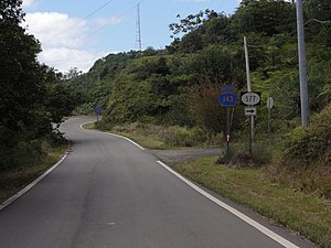 A scene on PR-143 westbound in Barrio Anón, Ponce, Puerto Rico
 A sign on westbound PR-143 in Barrio Ala de la Piedra, Orocovis, Puerto Rico, pointing out Ruta Panorámica near PR-149
_y_acercandose_a_la_Carretera_PR-577_hacia_el_Cerro_Maravilla,_Barrio_Anon,_Ponce,_Puerto_Rico_(DSC01621).jpg)
.jpg)
Tourist attractions
The road is a major part of Puerto Rico's Panoramic Route, being the major middle component of such route. It crosses Toro Negro State Forest, and leads to such landmarks as Cerro de Punta and Lago El Guineo lake.[5] The Orocovis-Villalba lookout and Cerro Maravilla as well as a number of local restaurants can be found along the way.
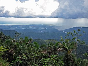 View of the southern coast of Puerto Rico from PR-143
 North entrance of Camino El Bolo trail of Toro Negro State Forest at PR-143 in Orocovis


.svg)
Route features
| No. | Kilometer Mark | Feature | Direction | Notes (about this "Feature") |
|---|---|---|---|---|
| 0 | 0.0 | PR-10 | North and South | To Ponce (SB) or to Adjuntas (NB) |
| 1 | 3.3 | PR-521 | North | To Jayuya |
| 2 | 3.9 | PR-503 (also to PR-505) | South | To Ponce |
| 3 | 7.3 | PR-140 | North | To Jayuya |
| 4 | 7.9 | San Patricio Elementary School | North | - |
| 5 | 11.6 | PR-139 | South | To Ponce |
| 6 | 12.4 | PR-511 | South | To Ponce (blocked by landslides as of 01/15) |
| 7 | 16.7 | Cerro de Punta | North | Tallest mountain in PR |
| 8 | 18.2 | Monte Jayuya | North | Radio/TV Towers |
| 9 | 21.2 | PR-577 | North | Cerro Maravilla |
| 10 | 28.1 | PR-149 | South | To Villalba |
| 11 | 28.5 | PR-149 and sign to Toro Negro State Forest | North | To Ciales |
| 12 | 32.4 | PR DRNA Toro Negro State Forest Office | North | - |
| 13 | 39.6 | Mirador Villaba-Orocovis (Scenic Lookout) | South | - |
| Municipality | Location | km [1][2][3] | mi | Destinations | Notes | |||
|---|---|---|---|---|---|---|---|---|
| Adjuntas | Saltillo | 0.0 | 0.0 | Western terminus of PR-143; western terminus of the Ruta Panorámica concurrency; the Ruta Panorámica continues toward Adjuntas | ||||
| 0.5– 0.6 | 0.31– 0.37 | |||||||
| Portugués | 3.4 | 2.1 | ||||||
| Utuado | Consejo | 3.9 | 2.4 | |||||
| Ponce–Jayuya– Utuado municipal tripoint | San Patricio–Pica– Consejo tripoint | 7.4 | 4.6 | |||||
| Jayuya–Ponce municipal line | Jauca–Anón line | 11.8 | 7.3 | |||||
| 12.7 | 7.9 | Blocked by landslides as of January 2015 | ||||||
| Ponce | Anón | 21.9 | 13.6 | |||||
| Juana Díaz |
No major junctions | |||||||
| Orocovis–Villalba municipal line | Ala de la Piedra–Villalba Arriba line | 29.0 45.4[lower-alpha 1] | 18.0 28.2 | Southern terminus of PR-149 concurrency | ||||
| Orocovis | Ala de la Piedra | 44.8[lower-alpha 1] 29.1 | 27.8 18.1 | Northern terminus of PR-149 concurrency | ||||
| Bauta Abajo | 34.0 | 21.1 | ||||||
| 39.3 | 24.4 | |||||||
| Villalba | Caonillas Arriba | 41.5– 41.6 | 25.8– 25.8 | |||||
| Orocovis–Coamo municipal line | Bermejales–Pedro García line | 46.4 | 28.8 | |||||
| Bermejales–Bauta Arriba– Pedro García tripoint | 46.7 | 29.0 | ||||||
| Coamo | Hayales | 51.1 | 31.8 | |||||
| Coamo–Barranquitas municipal line | Hayales–Palo Hincado line | 52.5 | 32.6 | |||||
| Hayales–Helechal line | 54.1 | 33.6 | Eastern terminus of the Ruta Panorámica concurrency; the Ruta Panorámica continues toward Aibonito | |||||
| Barranquitas | Helechal | 58.1 | 36.1 | |||||
| 58.7 | 36.5 | Eastern terminus of PR-143 | ||||||
1.000 mi = 1.609 km; 1.000 km = 0.621 mi
| ||||||||
- Kilometer markers represent the distance along PR-149 rather than PR-143.
- Google (25 February 2023). "PR-143 west" (Map). Google Maps. Google. Retrieved 25 February 2023.
- Google (25 February 2023). "PR-143 center" (Map). Google Maps. Google. Retrieved 25 February 2023.
- Google (8 March 2020). "PR-143 east" (Map). Google Maps. Google. Retrieved 8 March 2020.
- "Orocovis, Memoria Núm. 47" (PDF). Puerto Rico Planning Board (in Spanish). 1955. Retrieved 4 August 2020.
- "Tránsito Promedio Diario (AADT)". Transit Data (Datos de Transito) (in Spanish). DTOP PR. pp. 78–79. Archived from the original on 1 April 2019.
This Puerto Rican location article is a stub. You can help Wikipedia by expanding it. |
This Puerto Rico road-related article is a stub. You can help Wikipedia by expanding it. |