Roads_and_expressways_in_Poland
Controlled-access highways in Poland are part of the national roads network and they are divided into motorways and expressways. Both types of highways feature grade-separated interchanges with all other roads, emergency lanes, feeder lanes, wildlife crossings and dedicated roadside rest areas. Motorways differ from expressways in their technical parameters like designated speed, permitted road curvature, lane widths or minimal distances between interchanges. Moreover, expressways might have single-carriageway sections in case of low traffic densities (as of 2024, such sections constitute 3.5% of the highway network).
The development of modern highways began in the 1970s, but proceeded very slowly under the communist rule and for the first years afterwards – between 1970 and 2000 only the total of 434 km of highways were constructed (5% of the planned network).[1] Further 1050 km (13% of the network) were opened from 2001 to 2010, followed by 2773 km (34% of the network) constructed between 2011 and 2020.[2] It is planned to open about 3000 km (about 37%) in the 2020s, while the last 10% would be completed after 2030.[3]
As of April 2024[update], there are 5115,6 km[4] of motorways and expressways in operation (62% of the intended network), while contracts for construction of further 1030 km[5][6] (13% of the network) are ongoing.
Except for the single-carriageway expressways, both types of highways fulfill the definition of a motorway as characterized by OECD, WRA or Vienna Convention. Speed limits in Poland are 140 km/h on motorways and 120 km/h on expressways (100 km/h in case of single-carriageway expressway sections). Some motorway stretches are tolled.
 Motorways are public roads with controlled access which are designated for motor vehicles only, and feature two carriageways with at least two continuous lanes each, divided by a median. They have no one-level intersections with any roads or other forms of land and water transport and have wildlife crossings constructed above the road. They feature emergency lanes and feeder lanes, and are equipped with dedicated roadside rest areas. Motorways are the only roads in Poland which use blue background on road signs - others use green road signs.
 Expressways share most of the characteristics of motorways, differing mainly in that:
- Expressways are designated for lower speed than motorways. For example, the road curvature can be higher and the lanes are usually narrower (3.5 m vs 3.75 m). Emergency lanes can also be narrower (2.5 m vs 3 m) and in exceptional situations expressways might not have them at all.
- Expressways can have a single carriageway on sections with low traffic density.
- Motorways can have interchanges only with main roads and the distance between interchanges is typically not less than 15 km (or 5 km near major cities), while expressways typically have more frequent interchanges. In exceptional situations, expressways might not have dedicated feeder lanes on interchanges.
Formally, expressways are also allowed to admit a one-level junction with a minor public road in exceptional cases,[7] however in 2020 the last such remaining junction in Poland was reconstructed into a two-level interchange.[8][9][10]
Speed limits
| Maximum speed (km/h) | |||
|---|---|---|---|
| Vehicle | |||
| Private car, motorbike, van up to 3.5 t (does not apply if towing trailer) | 140 | 120 | 100 |
| Bus meeting additional technical requirements | 100 | ||
| Bus; a vehicle over 3.5 t or towing trailer or carrying dangerous materials | 80 | ||
| Vehicle having equipment more than 1.5 m forward of the driver's seat | 60 | ||
|
Motorbike (including towing trailer) carrying a child up to 7 years-old |
40 | ||
| Not allowed on motorways: pedestrians, bikes, mopeds, agricultural vehicles. Minimal speed on motorways is 40 km/h unless there are any extraordinary circumstances (e.g., snow, ice, or a car broken down). It is forbidden to stop except extraordinary situations, or travel backwards. Towing is not allowed on motorways, but is permitted on expressways. | |||
In 2004, the government published a document defining the planned highway network of length about 7,200 km (4,474 mi).[11] Notable changes introduced in later amendments include re-routing S8 and adding S61 instead (a change related to the Rospuda Valley conflict),[12] introducing S16, S52 and A/S50,[13] as well as extending S5,[14] S8[15] and S10.[16][17][13]
The planned network consists of 16 major highways (over 200 km of intended length): A1, S3, S5, S7, S11, S17, S19, S61 running north to south and A2/S2, A4, S6/A6, S8/A8, S10, S12, S16, S74 running west to east, as well as 9 shorter highways:[lower-alpha 1][lower-alpha 2] [20][21][22][23][3]
1) Highways and major sections completed | |||||||||||||
|---|---|---|---|---|---|---|---|---|---|---|---|---|---|
| Sign | Route | Location | Total length | Existing | Years of construction | ||||||||
| Gdańsk (S6) - Grudziądz (S5) - Toruń (S10) - Łódź (A2/S8) - Gliwice (A4) - |
566.6 km | 566.6 km | 100% | 2005 – 2022 [lower-alpha 3] | |||||||||
| Main section: |
489.7 km[lower-alpha 4] | 100% | mainly 2001 – 2013 [lower-alpha 5] | ||||||||||
| Main section: Szczecin (A6) - Gorzów Wlkp. - Jordanowo (A2) - Zielona Góra - Lubin - Legnica (A4) |
301.9 km[lower-alpha 6] | 301.9 km | 100% | 2008 – 2021 [lower-alpha 7] | |||||||||
| 669 km | 669 km of which 103 km substandard: no hard shoulder |
100% | 1976 – 2016 | ||||||||||
| Main section: Grudziądz (A1) - Bydgoszcz (S10) - Poznań (A2/S11) - Wrocław (A8) |
340.3 km[lower-alpha 8] | 340.3 km | 100% | 2009 – 2022 [lower-alpha 9] | |||||||||
| Main section: Wrocław (A4) - Łódź (A1) - Piotrków T. - Warsaw (A2/S7) - Ostrów M. (S61) - Białystok (S19) |
548.2 km[lower-alpha 10] | 100% | 2008 – 2019 [lower-alpha 11] | ||||||||||
| S8 - Pabianice - Zgierz - A2 | Łódź (western bypass) |
40.2 km | 40.2 km of which 0.5 km substandard: an at-grade roundabout |
100% | 2010 – 2023 | ||||||||
| Main section: Warsaw (A2) – Lublin (S12/S19) |
150 km[lower-alpha 12] | 150 km | 100% | 2010 – 2020 [lower-alpha 11] | |||||||||
| 76.5 km | 76.5 km of which 5.6 km substandard: no hard shoulder |
100% | 2004 – 2006 2020 – 2023 [lower-alpha 13] | ||||||||||
| Elbląg – |
52.2 km | 52.2 km single carriageway |
50% | 2006 – 2008 [lower-alpha 14] | |||||||||
| Olsztyn (S16) – Olsztynek (S7) | 20.3 km | 20.3 km | 100% | 2009 – 2019 | |||||||||
| Warsaw – airport – S2 | Warsaw | 4.8 km | 4.8 km | 100% | 2009 – 2013 | ||||||||
| Katowice – Sosnowiec | Upper Silesia | 5.9 km | 5.9 km | 100% | 1978 – 1985 | ||||||||
2) Highways in development | |||||||||||||
| Sign | Route | Location | Total length | Existing | In realisation[lower-alpha 15] | Of which under active construction | Scheduled year(s) of opening[6] | Tender | In predesign[lower-alpha 16] | ||||
| Pyrzowice (A1) - Mysłowice (A4) - Bielsko-Biała (S52) - Zwardoń - |
144 km | 72 km + 17 km single carriageway |
55.9% (61.8%) |
4.8 km + 3.7 km single carriageway |
2025 | ||||||||
| (+ 44 km) dual carriageway road |
(94.1%) | + 7 km (reconstruction of the 2x2 road to a highway; 1 lane per each direction is open to traffic) |
2024 | ||||||||||
| + 39.5 km (new route) |
+ 27 km (new route) |
2025 | |||||||||||
| Eastern section: Warsaw (S17) – |
168.2 km | 35.1 km | 20.9% | 100.8 km | 2024, 2025, 2028? | 32.3 km | |||||||
| Northern section: Świnoujście – Szczecin (A6) |
85.4 km | 50.9 km + 5.4 km 1st carriageway |
62.8% | 29.1 km + 5.4 km 2nd carriageway |
2024 | ||||||||
| Southern section: Legnica (A4) – |
66.8 km | 47.7 km of which 3 km near the Czech border remain closed until connecting D11 is opened |
71.4% | 19.1 km | |||||||||
| Main section: |
402.4 km[lower-alpha 19] | + 9.4 km 1st carriageway |
62.2% | 147.7 km + 9.4 km 2nd carriageway |
2024, 2025 | ||||||||
| Gdańsk (A1)[lower-alpha 18] - Elbląg (S22) - Olsztynek (S51) - Warsaw (S8) | approx. 674 km | 276 km | 82.7% |
45 km (reconstruction of the 2x2 road to 2x3 highway; 2+2 lanes are open on the whole length, except for Vistula bridge where 2+1 lanes are available with the middle lane's direction changing based on the times of day) |
2025, 2027, 2032? | 13 km (reconstruction + new route) | |||||||
| (+ 58 km) dual carriageway road |
(100%) | ||||||||||||
| Warsaw (S2) - Radom (S12) - Kielce (S74) - Kraków (A4) | 258.1 km |
91.6% | 23.6 km |
2024, 2025 | |||||||||
| Kraków (A4) – Rabka-Zdrój (planned extension to |
31.8 km | 56% | (2030?), 2038?[lower-alpha 20] | approx. 25 km (new route) | |||||||||
| (+ 25 km) dual carriageway road |
(100%) | ||||||||||||
| Eastern section: Lublin (S17/S19) - Chełm - |
103.7 km[lower-alpha 21] | 29.2 km | 28.2% | 68.8 km | 14 km | 2025, 2027, 2030? |
5.7 km | ||||||
Via Carpatia |
572.5 km | 18.5 km 1st carriageway |
2.9% | 195.8 km + 18.5 km 2nd carriageway |
87.8 km | 2025, 2026, 2027, 2028? |
34.1 km | 69.4 km | |||||
| Lublin (S12/S17) – Rzeszów (A4) | 141.7 km + 16.3 km 1st carriageway with interchanging 2+1 lanes |
94.8% (100%) |
16.3 km 2nd carriageway |
2026 | |||||||||
| Rzeszów (A4) – |
11.4 km | 11.8% | 73.6 km | 42.6 km | 2025, 2026 tunnels: 2026, 2029? |
11.6 km | |||||||
part 2 |
Kraków-Balice (A4) – Kraków‑Mistrzejowice (S7) | Kraków (northern bypass) |
18.3 km | 5.8 km | 31.4% | 12.5 km | 2024 | ||||||
Via Baltica |
Ostrów Mazowiecka (S8) - Łomża - Ełk (S16) - Suwałki - |
210.7 km | 197.8 km | 93.9% | 12.9 km | 2024/2025[lower-alpha 22] | |||||||
3) Highways partially in development | |||||||||||||
| Sign | Route | Location | Total length | Existing | In realisation | Of which under active construction | Tender | Predesign complete | In predesign[lower-alpha 16] | Planned completion [23][3] | |||
| Southern extension: Kłodzko – Wrocław (A8) (planned extension to |
approx. 82.4 km | 5.1 km | 6.2% | 32.5 km | 36.3 km | approx. 8.5 km | 2031, mainly 2027 | ||||||
| Main section: Szczecin (A6) - Piła (S11) - Bydgoszcz (S5) - Toruń (A1) |
297 km | 50.2 km + 17.5 km 1st carriageway |
19.8% | 40 km + 10.9 km 2nd carriageway |
112 km | 37.8 km | 2030 | ||||||
| + 39.5 km + 6.6 km 2nd c/w | |||||||||||||
| Koszalin (S6) - Piła (S10) - Poznań (A2/S5) - Ostrów Wlkp. - Kępno (S8) - Tarnowskie Góry - A1 | 556.5 km | 154.4 km + 10.5 km 1st carriageway |
28.7% | 25 km | 67.1 km + 4.2 km 2nd c/w |
77 km | 2030 | ||||||
| + 222.5 km + 6.3 km 2nd c/w | |||||||||||||
| Eastern section: Lublin (S12/S19) - Zamość - |
126 km | 9.6 km + 2 km 1st carriageway |
8.4% | 47.7 km | 44.3 km | 22.3 km | 2028 | ||||||
| + 2 km 2nd c/w | |||||||||||||
| Sulejów (S12) - Kielce (S7) - Sandomierz - Nisko (S19) | 207 km | 6.7 km | 3.2% | 108.6 km | 9.7 km | 92 km | 2030 | ||||||
4) Planned highways | |||||||||||||
| Sign | Route | Location | Total length | Existing | In realisation | Of which under active construction | Tender | Predesign complete | In predesign[lower-alpha 16] | Planned completion [23][3] | |||
| Eastern extension: Ostróda (S7) – Grudziądz (A1) |
approx. 104.3 km | 14.3 km | 13.7% | approx. 90 km | 2033 | ||||||||
| Western extension: Bolków (S3) – Świdnica – S8 |
approx. 50 km | 0 km | 0% | approx. 50 km | 2031 | ||||||||
| Western extension:[lower-alpha 17] Kołbaskowo (A6) – Goleniów (S3) |
Szczecin (western bypass) |
50.8 km | 0 km | 0% | 1.5 km | 49.3 km | 2030 | ||||||
| Eastern section: Włocławek (A1) - Płock - S7 (dir. Warsaw) |
approx. 120 km | 0 km | 0% | approx. 120 km | 2032 | ||||||||
| Western section: Piotrków Tryb. (A1) - Sulejów (S74) - Radom (S7) - Lublin (S17) |
185 km | 16.4 km + 6.0 km 1st carriageway |
10.7% | 29.1 km | 133.5 km + 6.0 km 2nd c/w |
2030 | |||||||
| Olsztyn (S51) - Ełk (S61) - Białystok (S19) | approx. 245 km | 29.7 km + 20.1 km 1st carriageway |
16.2% | 16.5 km | 19.7 km + 20.1 km 2nd c/w |
77.5 km | 2032 | ||||||
| + approx. 81.5 km | |||||||||||||
| Marki (S8) – Lubelska (A2/S2) | Warsaw (eastern bypass) |
17.3 km | 3.5 km | 20.2% | 13.8 km | 2032[lower-alpha 23] | |||||||
| CPK (A2) - Mińsk M. (A2) - CPK | Warsaw (2nd ring road) |
approx. 265 km | 0 km | 0% | 2035 | ||||||||
| 98 km | 37 km | 37.8% | 61 km | 2031 | |||||||||
|
In total | ||||||||||
|---|---|---|---|---|---|---|---|---|---|---|
| Highway type | Planned length | Existing | In realisation[lower-alpha 15] | Of which under active construction | Tender | Predesign complete | In predesign | No progress | ||
| approx. 2,086 km (1,296 mi) | 1853 km | 88.83% | 100.8 km | 100.8 km | approx. 132.3 km |
|||||
| approx. 6,030 km (3,747 mi) | 3090.1 km + 177.6 km 1st carriageway |
52.72% | 870 km + 3.7 km 1st c/w + 55.7 km 2nd c/w |
443 km + 3.7 km 1st c/w + 14.8 km 2nd c/w |
397.7 km + 24.3 km 2nd carriageway |
1.5 km | approx. 1493.1 km + 20.9 km 2nd carriageway |
73 km 2nd carriageway[lower-alpha 24] | ||
| Total | approx. 8,116 km (5,043 mi) | 4943.1 km + 177.6 km 1st carriageway |
62.00% | 970.8 km + 3.7 km 1st c/w + 55.7 km 2nd c/w |
543.8 km + 3.7 km 1st c/w + 14.8 km 2nd c/w |
397.7 km + 24.3 km 2nd carriageway |
1.5 km | approx. 1625.4 km + 20.9 km 2nd carriageway |
73 km 2nd carriageway | |
.jpg)
As of 2024, the operational sections of highways utilize the following cross-sections:
- 7% (354 km) – motorways and expressways with 2x3 or (occasionally) 2x4 or 2x5 lanes,
- 89.5% (4589 km) – motorways and expressways with 2x2 lanes,
- 3.5% (178 km) – single-carriageway expressways, of which: 109 km with 1+1 lanes, 53 km with 1+1 lanes and dual-carriageway fragments (2x2) around the interchanges, 16 km with interchanging 2+1 lanes.
All single-carriageway expressways are constructed with allocated space for a possible upgrade to dual-carriageway and all bridges above such highways are prepared to accommodate the second carriageway. Most of those sections are planned to be widened to full profile by 2033, the exceptions being S1 (near the Slovak border) and S22 (near the border with Kaliningrad Oblast) where widening is currently not expected.[3]
Since 2023, almost all highways are free for vehicles up to 3.5 tons of permissible maximum weight[25][26] (for a passenger car with a trailer, the joint permissible maximum weight of the car and the trailer must not exceed 3.5 tons[27]). On some sections, the old infrastructure for toll collection is still in place.
The privately-owned sections of A2 and A4 are tolled. In the closed system, there are toll stations on every interchange both entering and exiting the tolled section; the driver receives a ticket upon entering the motorway and pays on the exit, with the price dependent on the distance driven. In the open system, two toll stations are located at the ends of the section; a person driving the whole distance pays at both gates, while a person entering or leaving the motorway mid-section pays only at one gate. The following sections are tolled:
- A2 Rzepin – Poznań-West (managed by AWSA): 133 km, 50 PLN ($12), closed system. (The bypass of Poznań is free. In particular, it means a person driving through S5 or S11 does not need to pay for using the common section of A2.)
- A2 Poznań-East – Sługocin (managed by AWSA): 85 km, 64 PLN ($16), open system.
- A4 Mysłowice – Kraków-Balice (managed by Stalexport): 52 km, 32 PLN ($7), open system; it is possible to pay automatically using electronic toll collection by the Autopay mobile app,[28][29] which allows one to save much time by choosing the "fast gates" for e-toll, instead of waiting in the queue to the regular gates that support both manual and electronic toll collection. (The bypass of Kraków is free. In particular, it means a person driving through S7 does not need to pay for using the common section of A4.)
Vehicles over 3.5 tons and buses
Using e-Toll is obligatory for buses as well as all vehicles with maximum permissible weight exceeding 3.5 tons (including the trailer) while driving on the Polish roads (not just the highways). More details can be found on the e-Toll website.[30]
Traffic volumes in Poland note rapid increase since the fall of communism in 1989: the annual average daily traffic recorded in 2020 amounts to over 360% of the average traffic recorded in 1990.[31][32] With the increasing traffic, the length of overburdened single-carriageway national roads[33] had also been steadily increasing until reaching the maximum of 1389 km in 2010.[34] Due to the large number of highway sections opened between 2010 and 2020, in that decade the length of overburdened roads has fallen down for the first time in history, from 1389 km in 2010 to 1121 km in 2020.[32]
The latest general measurement was conducted in 2020, although some measurement days were moved to 2021 due to the COVID-19 pandemic which would have caused the results from 2020 to be unreliable.[35] The following highways recorded the highest volumes:[36]
| Most busy highways in Poland (absolute numbers) | |||
|---|---|---|---|
| No | Section | Vehicles / day | Notes |
| 1 |
198'000 114'000 |
Highest AADT on sections with 5 lanes per direction: 198k (S7/S8), 114k (S2). | |
| 2 | S86 | 113'000 | S86 serves mainly local traffic between Sosnowiec and Katowice and is not part of Poland's transit network. 3 lanes per direction. |
| 3 | A4 in Katowice | 105'000 | A4 serves both the transit traffic (2 lanes per direction) and local traffic (2 lanes per direction). |
| Most busy highways in Poland (per number of lanes) | |||
| No | Section | Vehicles / day / number of lanes | Notes |
| 1 |
179'000 / 2x3 lanes |
S8 in Warsaw serves both the transit and local traffic, and long jams form on it during rush hours. | |
| 2 | S6, Gdańsk, Sopot and Gdynia bypass | 93'000 / 2x2 lanes |
Some decrease in traffic on S6 is expected after Tricity Outer Bypass (S7) is opened in mid 2025. |
| 3 | A4, Kraków western bypass | 85'000 / 2x2 lanes | Some decrease in traffic on A4 is expected after Kraków north-eastern bypass (S7/S52) is opened in mid 2025. Widening to 3 lanes per direction is planned in the future (after 2030). |
The other highest and lowest recorded AADT values were:
| Category | Section | Vehicles / day | Notes |
|---|---|---|---|
| Most busy regular national roads in Poland Note: Measurements are not performed on national roads within the borders of major cities | |||
| Most busy dual-carriageway national road | DK7 north of Warsaw | 63'000 | 2 lanes per direction with at-grade intersections and traffic lights. New parallel route of S7 is planned to be opened in the future (around 2032). |
| Most busy single-carriageway national road | DK44 west of Kraków | 36'000 | Widening to 2 lanes per direction is planned in the future (after 2030).[37] |
| Most busy single-carriageway national road within the planned highway network | DK19 north of Lublin | 28'500 | S19 is in realization (design-build), expected to be opened in late 2025. |
| Least busy highways in Poland | |||
| Least busy single-carriageway highway | S22 near |
800 | The results cannot be considered fully reliable, because the measurement has been conducted while major restrictions in entering European Union via its external border were in force because of the COVID-19 pandemic.[32] |
| Least busy dual-carriageway highway | A4 near |
1'800 | |
| Least busy highway excluding near-border sections | S11 Szczecinek bypass | 3'900 – 6'400 | |
Motorways and expressways constructed before 1999 do not have to fulfill technical parameters listed in the ordinance. As of 2024, one notable case of a substandard highway remains:
- A4 on the section Krzyżowa – Wrocław (103 km (64 mi)) was constructed in years 1934 – 1937 (then the territory of Nazi Germany) and renovated in years 2002 – 2006. The road received new high quality surface but the geometry was kept unchanged and many overpasses above the motorway were kept. In effect, this part has no emergency lanes and the speed limit is decreased to 110 km/h. Its full reconstruction (and widening to three lanes per direction) is scheduled for years 2026 – 2030.[38]
Notable historical cases are:
- S3 near Szczecin (19 km) was opened in 1979 and it featured two at-grade road intersections, as the last such expressway section in Poland, until the reconstruction in years 2019 – 2020.[8][10]
- A6 near Szczecin (29 km) was constructed by Nazi Germany and kept using the original surface made of concrete slabs until the reconstruction conducted in years 1996 – 1999 and (easternmost fragment) 2017 – 2021.[39]
- A18 (70 km) had its southern carriageway constructed by Nazi Germany. The northern carriageway was constructed in 2004 – 2006, while southern carriageway kept using the original concrete slabs until the reconstruction conducted in years 2020 – 2023.
Before World War II
The first plans of creation of a national highway network in Poland were conceived in the interwar period:
The main promoter of this concept was Professor Melchior Wladyslaw Nestorowicz of the Warsaw University of Technology, who organized three Road Congresses, during which a group of specialists discussed the creation of the network. On March 5, 1939, in the trade magazine Drogowiec, Professor Nestorowicz proposed a very ambitious plan for the construction of almost 5,000 kilometres of category I and II roads, based on similar programmes in Germany and Italy.[40] Nestorowicz sketched a map of the future system with the following routes:
First class roads would, according to the plans, consist of the following motorways (totalling some 2,500 km (1,553.4 mi):
- Warsaw - Łódź - 100 km
- Warsaw – Poznań - Polish-German border - 350 km
- Warsaw beltway - 130 km
- Poznań beltway - 80 km
- Gdynia – Bydgoszcz – Łódź – 500 km
- Łódź beltway - 90 km
- Bytow - Free City of Danzig border - 50 km
- Katowice – Kraków – Lwów - 375 km
- Warsaw – Lublin - Lwów – Sniatyn - Polish-Romanian border - 550 km
- Puławy – Sandomierz – Przemyśl - 175 km
Second class roads would consist of the following motorways, totalling another 2,295 km (1,430 mi):
- Piotrków Trybunalski - Kielce - Sandomierz - 180 km
- Warsaw – Kielce – Kraków - 180 km
- Łódź - Kalisz - Polish-German border north of Wrocław - 130 km
- Warsaw – Grodno – Vilnius – Polish - Lithuania - Latvian border near Daugavpils - 575 km
- Grodno - Nowogrodek - Polish-Soviet border near Minsk - 190 km
- Bydgoszcz – Poznań – Częstochowa - 350 km
- Katowice – Cieszyn – Polish-Czechoslovak border - 60 km
- Ostrołęka - Polish-East Prussian border - 50 km
- Grodno - Polish-Lithuanian border - 40 km
- Grodno - Brzesc nad Bugiem - Krasnystaw - 300 km
- Warsaw – Brzesc nad Bugiem - 170 km
In 1934, Nazi Germany started the construction of their motorway system, parts of which today form A18 and A4 to Wrocław (Breslau), as well as A6 Szczecin bypass and S22 (parts of the planned motorway to Königsberg). About half of them were constructed as single-carriageway with the intention of adding a second carriageway in later years. However, after 1938, warfare expenses meant little money would be invested into any infrastructure and only one 9 km single-carriageway piece west of Gliwice (now A4) was constructed.
| Highway sections constructed by Nazi Germany | |||||
|---|---|---|---|---|---|
| Signage | Section | Length | Start of construction | Opening | Notes |
| Krzyżowa ( |
12.3 km (7.6 mi) | 1934 | 17 October 1937 | ||
| Krzywa – Wrocław | 91 km (56.5 mi) | 27 September 1936 | |||
| Wrocław – Brzeg (Owczary) | 34.1 km (21.2 mi) | 1938 | Southern carriageway only | ||
| Ujazd (Nogowczyce) – Łany | 9.1 km (5.7 mi) | 1940 | 1942 | ||
| Łany – Kleszczów (Gliwice) | 8.8 km (5.5 mi) | 1936 | 1938 | ||
| 2.6 km (1.6 mi) | 1934 | 27 September 1936 | |||
| Szczecin-Zachód – Rzęśnica | 26.6 km (16.5 mi) | 1938 | |||
| 37.2 km (23.1 mi) | 1936 | 1938 | Southern carriageway only | ||
| Iłowa – Golnice | 32 km (19.9 mi) | 1935 | 17 October 1937 | ||
| Golnice – Krzyżowa ( |
5.9 km (3.7 mi) | 1936 | 1938 | ||
| Elbląg – Grzechotki | 51.4 km (31.9 mi) | 1934 | 1938 | Western carriageway only | |
| Total | 316.9 km (196.9 mi) of which 178.5 km (110.9 mi) single carriageway |
Note: Signage of the roads at the time of opening was different. | |||
In Poland, a 28 km stretch between Warlubie and Osiek (now DW214) was constructed in 1937 – 1939 in the motorway standard of the time (today not considered a highway) with a concrete surface, which was designed by Italian engineer Piero Puricelli. The motorway was planned to reach Gdynia, but the outbreak of the Second World War halted the plans.
1945 – 1972
The Potsdam conference defined the borders for communist Poland, which were very different from the pre-1939 ones. It received the so-called Regained Territories from the former Third Reich with the aforementioned motorway sections (some of them with first carriageway only). Most of the motorway bridges were destroyed by the warfare, but only a few were repaired or rebuilt in the first post-war years. The bridge over Ina river was reconstructed in 1972, and those on S22 only between 1996 and 2003.
Apart from the bridges, almost all the motorways were left in the same condition as they were in 1945 until the mid-1990s. The only road left from Nazi times that was completed by the People's Republic of Poland was a one-carriageway small section between Łęczyca and Lisowo (15 km of what is now DW142), which was built on the previous works of Nazis.
At the post-war year there were very ambitious plans to make a motorway network for the whole Poland. For example, engineer Eugeniusz Buszma has published his propositions to the network in the magazine "Drogowiec" (1946, issue 1):
- East – West (Słubice – Warsaw – Białystok) – 680 km
- North – South (Gdynia – Warsaw – Balkans) – 650 km
- Silesia – Baltic I (Gdańsk – Łódź – Katowice) – 460 km
- Pomeranian (Gdańsk – Szczecin) – 280 km
- Silesian (Wrocław – Katowice – Kraków) – 190 km
- Mazurian (Kaliningrad – Elbląg – Malbork) – 20 km
- Silesia – Baltic II (Bydgoszcz – Wrocław) – 260 km
- Łódź – Wrocław – (Prague) – 310 km
- Katowice – (Vienna) – 60 km
- Poznań – Szczecin – 200 km
- Radom – Lublin – (Lviv) – 220 km
In total, the mileage, according to the proposal, would total more than 3,300 km (2,050 mi).
After the addition of the sections built by the Third Reich the total network length had to be approx. 3700 km. In 1963 the Motorization Council at the Council of Ministers had presented the similar plan plus the motorways: Warsaw-Kraków-Zakopane, Kraków-Przemyśl, Warsaw-Bydgoszcz-Koszalin, Poznań-Koszalin i Warsaw-Terespol (approx. 1250 km). None of those plans were realized, however.
Despite announcing such pompous plans, no motorway was opened in the meantime.
In the 1970s
Only in the 1970s did any works start.
In 1972 it was planned to build:
- the Gliwice-Kraków motorway (now A4)
- the second carriageway of the Wrocław-Gliwice motorway (also A4)
- the Warsaw-Katowice motorway (so-called "Gierkówka", now the S8/A1 road), in the near future
The plans were expanded in 1976 by the following sections:
- Tarnów – Kraków (now A4),
- eastern GOP (Górnośląski Okręg Przemysłowy) bypass (now S1, northern part),
- Bielsko-Biała – Cieszyn (now S52, southern part),
- Warszawa – Poznań (so-called Olimpijka, now A2),
- Łódź – Piotrków Trybunalski (now A1).
In 1973 – 1976, "Gierkówka" dual carriageway from Warsaw to Katowice (281 km (175 mi)) was built. Originally planned as a motorway, it was in the end constructed by adding another carriageway to the existing road, hence going through many villages and crossing with local roads. The part from Piotrków Trybunalski to Częstochowa (78 km) was constructed on a new route in a motorway alignment, but nonetheless the majority of the crossings between the highway and the other roads were constructed as one-level intersections with no viaducts or overpasses.
| Signage | Section | Length | Start of construction | Opening |
|---|---|---|---|---|
| Piotrków Trybunalski – Częstochowa substandard (multiple at-grade intersections), constructed on motorway alignment, not signed as a highway |
78 km (48 mi) | 1973 | 1976 | |
| Tri-city bypass (eastern carriageway) substandard (two at-grade intersections, then reconstructed when adding a second carriageway in the 1980s) |
37.7 km (23.4 mi) | 1973 | 1977 | |
| Rzęśnica (end of post-German A6 motorway) – Goleniów substandard (two at-grade intersections) |
19.3 km (12.0 mi) | 1976 | 1979 | |
| Total | 57 km (35.4 mi) of which 37.7 km (23.4 mi) single carriageway | |||
In the 1980s
Near the end of the 1970s the first construction of motorways started and continued to the next decade. The roads opened in the 1980s were the first motorways and expressways which generally meet the contemporary standards (at least with respect to their more important attributes), although in multiple cases the poor quality of their construction forced major renovations to be performed as soon as within the first 20 years of operation.[41][42]
The major routes planned as motorways were A1, A2 and A4, while other main routes were planned as expressways. The implementation of these plans, however, came at a very slow pace: throughout the 1980s, only an average of 20 km (12 mi) of highways in the whole country were being opened per year.
| Highway sections opened in the 1980s average: 20.5 km / year | |||||
|---|---|---|---|---|---|
| Signage | Section | Length | Start of construction | Opening | Notes |
| Tuszyn-Piotrków Trybunalski | 16.1 km (10.0 mi) | 1978 | 18 December 1989 | Reconstructed 2019 – 2021 | |
| Września-Sługocin (Golina) | 35.7 km (22.2 mi) | 1977 | 9 October 1985 | Renovated 2002 – 2003 | |
| Sługocin - Konin West | 13.5 km (8.4 mi) | 1986 | 10 November 1988 | ||
| Chrzanów - Kraków (Balice I) | 29.6 km (18.4 mi) | 1976 | 3 January 1983 | Renovated 1999 – 2000 | |
| Jaworzno - Chrzanów | 6.1 km (3.8 mi) | 1978 | 22 November 1986 | ||
| Kraków bypass (section Balice I - Tyniec) | 7.8 km (4.8 mi) | 1979 | 8 December 1988 | ||
| Dąbrowa Górnicza - Tychy | 34.7 km (21.6 mi) | 1978 | 1983 | ||
| Tri-city bypass (to Straszyn) | 32.4 km (20.1 mi) | 1978 | 1984 | Second carriageway | |
| Kielce bypass | 22.9 km (14.2 mi) | 1974 | 1984 | First carriageway | |
| Katowice - Sosnowiec | 6.8 km (4.2 mi) | 1978 | 1985 | First completely done expressway | |
| Total | 205.6 km (127.8 mi) of which 55.3 km (34.4 mi) single carriageway | ||||
In the 1990s
In the III Republic of Poland, planned S3 was promoted to motorway A3 (the decision was later reversed) and a plan was introduced (also later reversed) of constructing motorway A8 Łódź – Wrocław – Bolków (now S8/A8/S5). Szczecin bypass (A6) and section Olszyna – Krzywa (then named A12, now A4/A18) were promoted to motorways, even though at that time the majority of their lengths was in bad shape, laid with the original concrete surface from the 1930s with no significant works having been performed on any of them throughout the whole communist period.
| Highway sections opened in the 1990s average: 15 km / year | |||||
|---|---|---|---|---|---|
| Signage | Section | Length | Start of construction | Opening | Notes |
| Mysłowice - Jaworzno | 15.9 km (9.9 mi) | 1986 | 29 November 1990 | Northern carriageway | |
| 4 September 1991 | Southern carriageway | ||||
| Kraków bypass (section Tyniec - Skawina) | 3.5 km (2.2 mi) | 1988 | 1993 | ||
| Kraków bypass (section Skawina - ul.Kąpielowa) | 5.4 km (3.4 mi) | 1993 | 27 October 1995 | A4 had a crossroad with ul. Kąpielowa till 2002, when the bridge was built over it. | |
| Jędrzychowice |
1.8 km (1.1 mi) | 1992 | 15 July 1994 | ||
| Katowice Francuska - Mysłowice | 11.1 km (6.9 mi) | 1989 | 30 October 1996 | ||
| Katowice Mikołowska - Katowice Francuska | 1.9 km (1.2 mi) | ? | 10 November 1999 | ||
| Krzyżowa - Krzywa | 10.2 km (6.3 mi) | 1995 | Renovated | ||
| 12.7 km (7.9 mi) | 1996 | 1999 | Renovated | ||
| Olszyna |
9.6 km (6.0 mi) | ? | 1993 | Northern carriageway added (+ 350 m (383 yd) renovated southern carriageway at the border) | |
| Golnice - Krzyżowa | 5.9 km (3.7 mi) | 1995 | Renovated both carriageways | ||
| Cieszyn |
5.2 km (3.2 mi) | 1991 | 1995 | ||
| Sulechów - Zielona Góra (Niedoradz) | 26.8 km (16.7 mi) | 1985 | 1995 | Western carriageway only | |
| Świecie bypass | 13 km (8.1 mi) | 1994 | 1998 | Single carriageway; dual carriageway near the interchanges | |
| Nowy Dwór Mazowiecki bypass | 14.6 km (9.1 mi) | 1990 | 1999 | ||
| Miłomłyn bypass | 5.1 km (3.2 mi) | 1995 | 1997 | Eastern carriageway only | |
| Radzymin bypass | 8.1 km (5.0 mi) | 1996 | 1998 | ||
| Total | 151.8 km (94.3 mi) of which 28.8 km (17.9 mi) reconstructed, 48.4 km (30.1 mi) single carriageway | ||||
In the 2000s
As of the beginning of 2000, the vast majority of national and international traffic routes were served by regular national roads with at-grade intersections and pedestrian crossings, most of them leading through the centres of cities, towns and villages, and most of them single carriageway. Only the following number of highways was present:
- about 275 km (171 mi) of modern dual-carriageway motorways and expressways (3.5% of the network as planned nowadays),
- about 90 km (56 mi) of single-carriageway expressways,
- about 125 km (78 mi) of not-resurfaced Nazi German motorways from the 1930s,
- about 150 km (93 mi) of not-resurfaced Nazi German motorways on sections where only the first carriageway had been constructed.
Before Poland received the EU membership
At the beginning of the 21st century, the tempo of highway construction started to increase. The main focus was on the west-east motorways A4 and A2. In 2002, a long-awaited renovation of the A4 from Krzywa to Wrocław (93 km) has started, which included laying new high quality surface in place of the Nazi German concrete slabs, reconstruction of all the pre-WWII bridges on the motorway and renovation of the viaducts above the motorway.
This is also the period when Poland started introducing motorway tolls, first in 2000 for the A4 section between Mysłowice and Kraków.
| Highway sections opened in 2000 – 2003 average: 57 km / year | |||||
|---|---|---|---|---|---|
| Signage | Section | Length | Start of construction | Opening | Notes |
| Poznań Komorniki - Poznań Krzesiny | 11.2 km (7.0 mi) | 1998 | 13 September 2003 | ||
| Poznań Krzesiny - Września | 37.3 km (23.2 mi) | 2002 | 27 November 2003 | ||
| Bielany Wrocławskie - Brzeg (Owczary) | 34.1 km (21.2 mi) | 1997 | 16 December 2000 | Southern carriageway reconstructed, northern carriageway constructed | |
| Brzeg (Owczary) - Dąbrówka Górna | 56.6 km (35.2 mi) | ||||
| Dąbrówka Górna - Nogowczyce | 34.3 km (21.3 mi) | 26 July 2001 | |||
| Nogowczyce - Kleszczów | 17.9 km (11.1 mi) | 2001 | 4 December 2003 | Southern carriageway reconstructed, northern carriageway constructed | |
| Chorzów - Katowice Mikołowska | 4.4 km (2.7 mi) | 1998 | 2001 | ||
| Kraków bypass (section ul.Kąpielowa - Wieliczka) | 7 km (4.3 mi) | 2000 | 3 September 2003 | ||
| Śmigiel bypass | 4.1 km (2.5 mi) | ? | 2002 | First carriageway | |
| Straszyn-Rusocin | 5.4 km (3.4 mi) | 2000 | 2001 | Second carriageway | |
| Białobrzegi bypass | 7.7 km (4.8 mi) | 2001 | 2003 | ||
| Ostrów Mazowiecka bypass | 7.6 km (4.7 mi) | 2000 | |||
| Total | 227.6 km (141.4 mi) of which 9.5 km (5.9 mi) single carriageway | ||||
Poland in European Union
1 May 2004 was a crucial day for the history of motorway construction and that is when the length of highway constructions increased the most. One of the major advantages of signing the European Union access document was that Poland could get access to large funds for co-financing the construction of new roads and upgrades of the existing road infrastructure.
These years, the existing scattered pieces of highways began to converge into the basis of the future network:
- until 2004, Katowice and Kraków (linked by A4) were the only pair of Poland's largest cities connected by a highway;
- in 2005, A4 connected Wrocław with Katowice and Kraków, while in 2009 – with Germany;
- in 2006, A2 connected Poznań with Łódź.
A large number of expressway bypasses of towns were also constructed at this time. On many of them, only one carriageway was built, with the allocated space prepared for easy construction of the second carriageway later.
| Highway sections opened in 2004 – 2010 average: 151 km / year | |||||
|---|---|---|---|---|---|
| Signage | Section | Length | Start of construction | Opening | Notes |
| Gdańsk (Rusocin) - Grudziądz | 24.2 km (15.0 mi) | 2005 | 2007 | ||
| 64.7 km (40.2 mi) | 2008 | ||||
| Sośnica - Żory | 15.6 km (9.7 mi) | 22 January 2007 | 20 October 2009 | ||
| 7.5 km (4.7 mi) | 2007 | 15 December 2010 | |||
| Nowy Tomyśl - Poznań Komorniki | 50.4 km (31.3 mi) | 2002 | October 2004 | ||
| Konin - Łódź (Stryków) | 103.7 km (64.4 mi) | 2004 | July 2006 | ||
| Krzywa - Bielany Wrocławskie | 93 km (57.8 mi) | 2002 | 2004–2006 (in sections) |
Renovated both carriageways | |
| Sośnica - Chorzów Batory | 15.7 km (9.8 mi) | 2002 | January 2005 | ||
| Kleszczów - Sośnica | 19.1 km (11.9 mi) | 2003 | October 2005 | ||
| Zgorzelec |
49.7 km (30.9 mi) | 2006 | August 2009 | ||
| Wieliczka - Targowisko | 19.5 km (12.1 mi) | 2007 | 2009 | ||
| Szczecin Klucz - Szczecin Kijewo | 7.7 km (4.8 mi) | 2005 | 2007 | Renovated both carriageways | |
| Olszyna |
71.5 km (44.4 mi) | 2004 | 2006 | Constructed the northern carriageway alongside the pre-WWII southern carriageway | |
| 12.0 km (7.5 mi) | 2002 - 2007 | 2004 - 2010 (in sections) |
Single carriageway; then signed S69 | ||
| Żywiec - Przybędza | 7.7 km (4.8 mi) | 2005 | 2007 | ||
| Pyrzowice airport - Podwarpie | 12.0 km (7.5 mi) | 2005 | 2006 | Single carriageway | |
| Szczecin – Gorzów Wielkopolski | 81.6 km (50.7 mi) | 2008 | 2010 | ||
| Gorzów Wielkopolski bypass | 11.9 km (7.4 mi) | 2003 | 2007 | Single carriageway | |
| Międzyrzecz bypass | 6.3 km (3.9 mi) | 2004 | 2006 | ||
| Nowa Sól bypass | 18 km (11.2 mi) | 2006 | 2008 | ||
| Szubin bypass | 4.5 km (2.8 mi) | 2004 | 2006 | Single carriageway | |
| Słupsk bypass | 16.3 km (10.1 mi) | 2008 | 2010 | Single carriageway; dual carriageway near the interchanges | |
| Jędrzejów bypass | 5.8 km (3.6 mi) | 2003 | 2005 | Partially (2.7 km) single carriageway | |
| Nowy Dwór Gdański bypass | 2.5 km (1.6 mi) | 2005 | 2007 | ||
| Elbląg bypass | 4.2 km (2.6 mi) | 2005 | 2007 | ||
| Grójec bypass | 8.3 km (5.2 mi) | 18 October 2006 | 19 September 2008 | ||
| Białobrzegi - Jedlińsk | 15.7 km (9.8 mi) | 6 July 2006 | 30 June 2008 | ||
| Myślenice - Lubień | 16.2 km (10.1 mi) | 2004 | 2009 | ||
| Kielce bypass (northern part) | 7.1 km (4.4 mi) | 2007 | 2009 | ||
| Płońsk bypass | 4.7 km (2.9 mi) | 28 September 2007 | 3 June 2009 | ||
| Skurów – Białobrzegi | 17.8 km (11.1 mi) | 2007 | 2010 | ||
| Kraków eastern bypass (first fragment) | 2.8 km (1.7 mi) | 2007 | 2010 | ||
| Oleśnica bypass | 7.2 km (4.5 mi) | 2004 | 2006 | ||
| Wyszków bypass | 12.8 km (8.0 mi) | 27 February 2006 | 14 November 2008 | ||
| Wyszków - Radzymin | 17.3 km (10.7 mi) | 8 December 2006 | 31 July 2009 | ||
| Wrocław - Kobierzyce | 7 km (4.3 mi) | 2007 | 31 December 2010 | ||
| Toruń bypass (fragment) | 12.4 km (7.7 mi) | 2004 | 2005 | Single carriageway; later incorporated into A1 | |
| Kobylanka bypass | 13.8 km (8.6 mi) | 2005 | 2007 | Partially (7 km) single carriageway | |
| Stargard bypass | 13.5 km (8.4 mi) | 2008 | 2009 | ||
| Bydgoszcz bypass (fragment) | 10.4 km (6.5 mi) | 2008 | 2009 | ||
| Wyrzysk bypass | 7.8 km (4.8 mi) | 2008 | 2009 | Single carriageway | |
| Poznań - Kórnik | 14.1 km (8.8 mi) | 2006 | 2009 | ||
| Ostrów Wlkp. bypass (northern part) | 6.1 km (3.8 mi) | 2008 | 2009 | Single carriageway | |
| Piaski bypass | 4 km (2.5 mi) | 2002 | 2004 | ||
| Puławy bypass | 12.7 km (7.9 mi) | 2005 | 2007 | Partially (8.7 km) single carriageway | |
| Barczewo – Biskupiec | 20.1 km (12.5 mi) | 2008 | 2010 | Single carriageway | |
| Garwolin bypass | 12.8 km (8.0 mi) | 2005 | 2007 | ||
| Międzyrzec Podlaski bypass | 6.3 km (3.9 mi) | 2005 | 2008 | Single carriageway | |
| Elbląg - Grzechotki / Kaliningrad Oblast | 51.6 km (32.1 mi) | April 2006 | December 2008 | Single carriageway; constructed in place of a partially destroyed motorway from the 1930s | |
| Cieszyn |
28 km (17.4 mi) | 2002 - 2005 | 2005 - 2007 (in sections) |
Then signed S1 | |
| Total | 1,055.6 km (655.9 mi) of which 276.6 km (171.9 mi) single carriageway, 100.7 km (62.6 mi) reconstructed | ||||
2011 – 2015
In the five years from 2011 to 2015, 1563 kilometers of motorways and expressways got opened – about as much as in the whole prior history of highway construction combined. The main focus was on developing connections between Poland's largest cities, especially those serving as host venues of UEFA Euro 2012, as well as on extending A4 towards Ukraine.
| Length of highways opened in 2011 – 2015 | ||
|---|---|---|
| Year | Length | Notes |
| 2011 | 313 km (194 mi) | |
| 2012 | 639 km (397 mi) | Of which 195 km (121 mi) were opened before Euro 2012 championship |
| 2013 | 298 km (185 mi) | |
| 2014 | 279 km (173 mi) | |
| 2015 | 34 km (21 mi) | |
| Total | 1,563 km (971 mi) | Of which 26 km (16 mi) first carriageway, 23 km (14 mi) second carriageway |
The sections opened in 2011 – 2015 belonged to the following highways:
 : + 273 km (170 mi) (A1 on the section Gdańsk – Łódź was completed in 2014)
 : + 234 km (145 mi) (A2 on the section Germany – Warsaw was completed in 2012)
 : + 88 km (55 mi) (S3 on the section Szczecin – A2 – Zielona Góra was completed in 2013, except that its older single-carriageway parts remained so until 2017)
 : + 183 km (114 mi)
 : + 138 km (86 mi)
 : + 365 km (227 mi) (S8 on the section Wrocław – Łódź was completed in 2014)


 : + 282 km (175 mi) in total
2016 – 2020
After the peak of investments before Euro 2012, very few new contracts for road construction have been signed in 2012 and 2013. This resulted in a small number of sections getting opened in 2015 and 2016, large share of which were the last delayed fragments originally scheduled for a Euro 2012 opening. In particular:
- In 2016, the last delayed fragment of between Kraków and Ukraine was opened, making A4 the first major Polish highway completed on its whole length, as well as the first complete border-to-border highway connection.
- Also in 2016, the delayed bypass of Łódź was finished, making completed on its whole route except for those sections where national road 1 had already been a dual carriageway (see In the 1970s), allowing for a significantly lower priority of constructing the remaining stretch compared to other highways.
Since 2014, the number of signed contracts has risen again, resulting in the number of road openings having risen again since 2017.
| Length of highways opened in 2016 – 2020 | ||
|---|---|---|
| Year | Length | Notes |
| 2016 | 123 km (76 mi) | |
| 2017 | 295 km (183 mi) | |
| 2018 | 318 km (198 mi) | |
| 2019 | 410 km (255 mi) | |
| 2020 | 135 km (84 mi) | |
| Total | 1,281 km (796 mi) | Of which 13 km (8 mi) first carriageway, 81 km (50 mi) second carriageway |
The sections opened in 2016 – 2020 belonged to the following highways:
- : + 173 km (107 mi)
 : + 227 km (141 mi) (S5 on the section Poznań – Wrocław was completed in 2019)
 : + 128 km (80 mi) (S6 on the section Szczecin – Koszalin was completed in 2019)
- : + 213 km (132 mi)
- : + 128 km (80 mi) (S8 was completed in 2019 on its originally intended route from Wrocław to Białystok; an extension to Kłodzko was later added to the plans)
 : + 97 km (60 mi) (S17 on the section Warsaw – Lublin was completed in 2020)


 : + 315 km (196 mi) in total (A4 was completed in 2016)
2021 – present
The high tempo of highway development continued in the 2020s. The main focus was on construction of new highways in the less populated eastern Poland, including the international routes Via Carpatia and Via Baltica.
| Length of highways opened, or to be opened, in 2021 – 2025 by the contract completion date | ||
|---|---|---|
| Year | Length | Notes |
| 2021 | 375 km (233 mi) | |
| 2022 | 267 km (166 mi) | |
| 2023 | 245 km (152 mi) | |
| 2024 | 142 km (88 mi) | Sections already opened and ongoing constructions[43] |
| 2025 | 526 km (327 mi) | Ongoing constructions[6] |
| Total | 1,555 km (966 mi) | Of which 7 km (4 mi) first carriageway, 111 km (69 mi) second carriageway |
The sections opened, or planned to get opened, in 2021 – 2025 belong to the following highways:
- : + 106 km (66 mi)
- : + 104 km (65 mi) (S3 is scheduled to get completed in 2024)
- : + 200 km (124 mi) (S6/A6 is scheduled to get completed in 2025 on its original route from Germany to Gdańsk; western bypass of Szczecin will be constructed later as an alternative parallel route)
- : + 196 km (122 mi) (S7 on the section Warsaw – Kraków is scheduled to get completed in 2025)
 : + 291 km (181 mi) (S19 "Via Carpathia" on the section Lublin – Rzeszów was completed in 2022, except that its older fragment with 2+1 lanes will remain so until 2026)
 : + 183 km (114 mi) (S61 "Via Baltica" is scheduled to get completed in 2025)
- ,
 , , , : + 60–80 km each (A1 was completed in 2022; S5 on the section Grudziądz (A1) – Poznań was completed in 2022; reconstruction of the second carriageway of A18 was completed in 2023; S1 is scheduled to get completed in 2025)

 : + 119 km (74 mi) in total
| Year | Highways, total length |
|---|---|
| 1936 (then Nazi Germany) | 92 km |
| 1937 (then Nazi Germany) | 104 km and 38 km first carriageway |
| 1938–1945 (then Nazi Germany) | 133 km and 135 km first carriageway (further below not considered as a motorway until addition of the second carriageway) |
| 1939–1945 (Poland) | 28 km (today not considered as a highway) |
| 1945–1976 | 133 km |
| 1977 | 169 km |
| 1978 | 169 km |
| 1979 | 190 km |
| 1980 | 190 km |
| 1981 | 190 km |
| 1982 | 190 km |
| 1983 | 255 km |
| 1984 | 278 km |
| 1985 | 321 km |
| 1986 | 327 km |
| 1987 | 327 km |
| 1988 | 348 km |
| 1989 | 366 km |
| 1990 | 381 km |
| 1991 | 399 km |
| 1992 | 399 km |
| 1993 | 403 km |
| 1994 | 405 km |
| 1995 | 440 km |
| 1996 | 453 km |
| 1997 | 456 km |
| 1998 | 490 km |
| 1999 | 502 km |
| 2000 | 592 km |
| 2001 | 630 km |
| 2002 | 639 km |
| 2003 | 727 km |
| 2004 | 781 km |
| 2005 | 848 km |
| 2006 | 1013 km |
| 2007 | 1083 km |
| 2008 | 1282 km |
| 2009 | 1454 km |
| 2010 | 1560 km |
| 2011 | 1865 km |
| 2012 | 2495 km |
| 2013 | 2805 km |
| 2014 | 3100 km |
| 2015 | 3131 km |
| 2016 | 3252 km |
| 2017 | 3510 km |
| 2018 | 3811 km |
| 2019 | 4214 km |
| 2020 | 4337 km |
| 2021 | 4690 km |
| 2022 | 4933 km |
| 2023 | 5116 km |
| 2024 | 5258 km (forecast[6]) |
| 2025 | 5776 km (forecast[6]) |
| 2026 | 6006 km (forecast[6]) |
| 2027 | 6180 km (forecast[6]) |
| 2028 | 6570 km (plans[3][23]) |
| 2030 | approx. 7000 km (plans[3][23]) |
| 2033 | approx. 8000 km (plans[3][23]) |
| After 2035 | approx. 8175 km – full network (plans[3]) |
- Major changes in the network (e.g. opening new fragments of roads, signing all contracts for a planned road section) are accounted continuously, while a general update including all the details is done once per year (last: 16 October 2023). 'In total' length statistic is kept consistent as of the last general update, and might hence not be the exact sum of the current state of the table.
- Some highways can overlap. The table shows data without overlapping sections such that each fragment is counted exactly once, in accordance with how they are attributed in the ministry ordinance,[18] i.e. each common section is attributed to the road with the lower number (in case of two expressways overlapping) or to a motorway (in case of a motorway and an expressway overlapping), except for S12/S17 west of Lublin which is recorded as S17 in the sources.[19]
- First 48 km constructed 1977 – 1988, reconstructed to modern standard 2002 – 2003.
Eastern half of S2 in Warsaw constructed 2017 – 2021. - The southern carriageway was constructed between 1935 and 1938 by Nazi Germany. The northern carriageway was constructed alongside it between 2004 and 2006, but the road was not marked as a motorway (except for a short fragment with both carriageways reconstructed), as only the west-bound traffic could use the motorway-quality carriageway, while the east-bound traffic kept using the old carriageway with concrete slabs from the 1930s. The southern carriageway was reconstructed to mordern motorway standard between 2020 and 2023 and the whole route was then designated as a motorway.
- Sections under active construction and sections under a joint Design & Build contract.
- In design (tender included), if it is being conducted as part of the predesign process rather than as part of a design-build contract.In the late predesign phase, i.e. after having obtained environmental decision (0–2 years to finish).In the process of obtaining environmental decision (including if a non-final decision has been issued and is being appealed from).
- The national road 6 is currently routed through the Szczecin Southern Bypass (motorway A6) and then through expressway S6. Ultimately, after completion of the Szczecin Western Bypass, this new route will become S6 (it is not clear if A6 then retains its number and there will be two parallel routes with number 6, or if renumbering takes place). Until S6 gets rerouted, the existing route 6 is accounted jointly in the table.
- According to the ordinance, a fragment of S6 (1st Tricity bypass) is ultimately to become a section of S7 after 2nd Tricity bypass (S6) is constructed. Until the actual relabelling takes place, this fragment is being accounted to S6 and not to S7 in the table.
- Section Kraków – Myślenice. By 2030, the existing dual-carriageway DK7 is planned to get upgraded with removing all at-grade intersections and pedestrian crossings. A 2x3 expressway (on a new route alignment) would be constructed around 2038, as the last section of the currently-planned highway network.[24]
- Here and in the following figures, construction of 1st or 2nd carriageway is accounted as half-length for consistency of the summed results. Sections constructed by Nazi Germany are accounted for the dates of their reconstruction to modern highways.
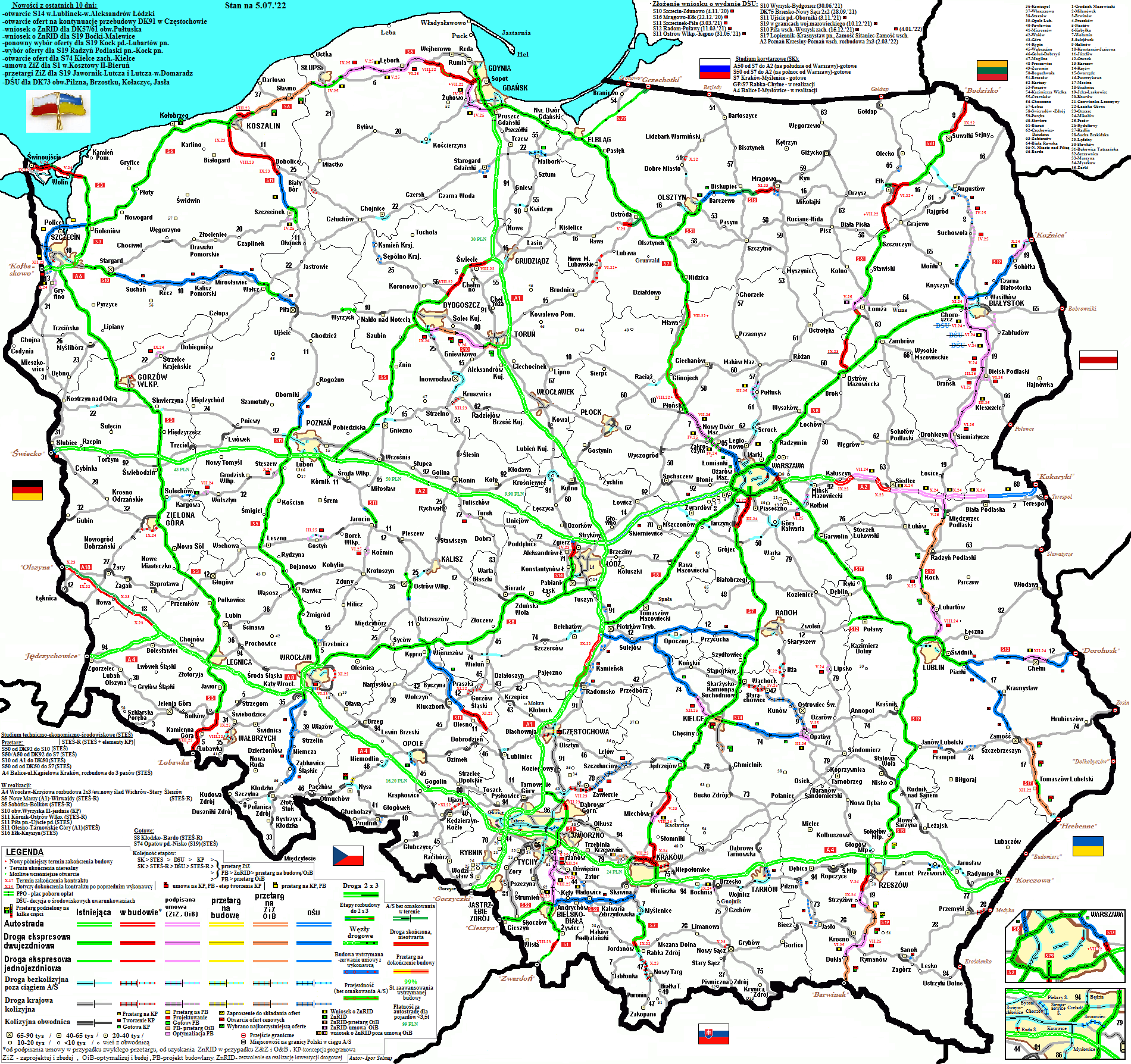
- https://www.gov.pl/web/gddkia/mapa-stanu-budowy-drog4, more details: History
- "Rządowy Plan Budowy Dróg do 2030 roku". www.gov.pl.
- "Autostrady :: Generalna Dyrekcja Dróg Krajowych i Autostrad - Strona Główna". www.gddkia.gov.pl.
- Including joint design–build contracts. Of these 563 km (350 mi) in active construction.
- The definitions and technical parameters of highways are defined in the Public Roads Act of 21 March 1985 (with later amendments): "Ustawa z dnia 21 marca 1985 r. o drogach publicznych". prawo.sejm.gov.pl. and the ministry ordinance of 2 March 1999 (with later amendments)."Obwieszczenie Ministra Infrastruktury i Budownictwa z dnia 23 grudnia 2015 r. w sprawie ogłoszenia jednolitego tekstu rozporządzenia Ministra Transportu i Gospodarki Morskiej w sprawie warunków technicznych, jakim powinny odpowiadać drogi publiczne i ich usytuowanie". prawo.sejm.gov.pl.
- "Miekowo Rześnica". Miekowo Rześnica.
- "Generalna Dyrekcja Dróg Krajowych i Autostrad - Generalna Dyrekcja Dróg Krajowych i Autostrad - Portal Gov.pl". Generalna Dyrekcja Dróg Krajowych i Autostrad.
- "Dziennik Ustaw 2019 r. poz. 1819". www.dziennikustaw.gov.pl.
- "Zmiany w rozporządzeniu w sprawie sieci autostrad i dróg ekspresowych - Ministerstwo Infrastruktury i Budownictwa". mib.gov.pl. Retrieved 5 July 2016.
- http://prawo.sejm.gov.pl/isap.nsf/DocDetails.xsp?id=WDU20180000741: Appendix 2, footnote 1 (in Polish)
- "WYNIKI_GPR_2015_DK.pdf" (PDF).
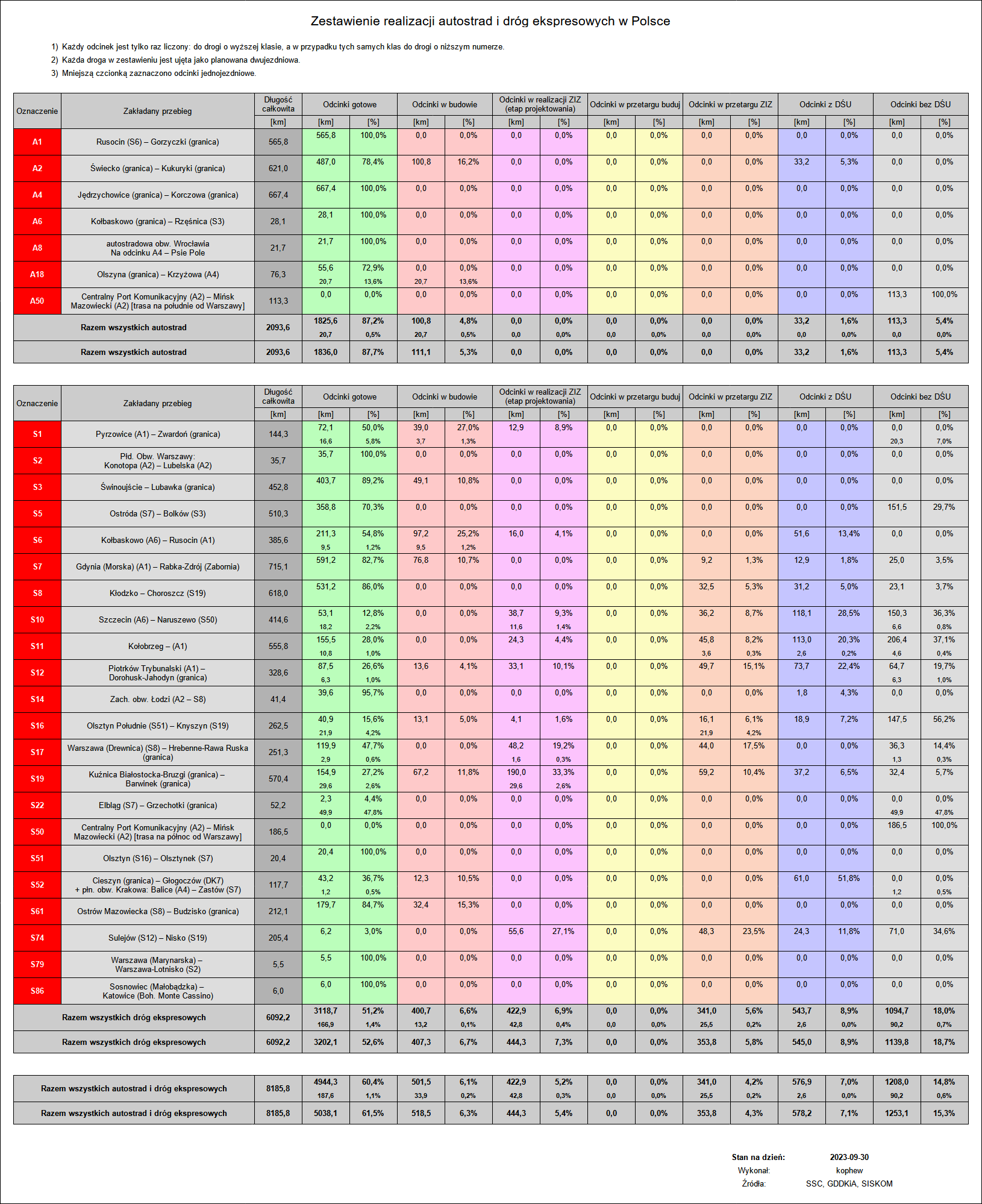
- "Zestawienie realizacji autostrad i dróg ekspresowych w Polsce". Retrieved 26 December 2019.
- "Mapa budowy dróg ekspresowych i autostrad". Retrieved 26 December 2019.
- "Map of construction of Polish highways - SISKOM & SSC". ssc.siskom.waw.pl. Retrieved 26 December 2019.
- "Map of construction of Polish highways - GDDKiA". gov.pl. Retrieved 31 July 2021.
- "Toll-free travel on motorway sections managed by GDDKiA (A2 Konin-Stryków and A4 Wrocław-Sośnica) for light vehicles from 1 July 2023" (in Polish). e-TOLL. Retrieved 1 July 2023.
- "Archived copy" (PDF). Archived from the original (PDF) on 27 January 2021. Retrieved 26 January 2020.
{{cite web}}: CS1 maint: archived copy as title (link) - The measurement analysis defines a regular single-carriageway road as overburdened if recorded average annual traffic exceeds 15'000 vehicles per day, see "Archived copy" (PDF). Archived from the original (PDF) on 27 January 2021. Retrieved 26 January 2020.
{{cite web}}: CS1 maint: archived copy as title (link) - "Zamów domenę". domains24.pl.
- "Historia przedsięwzięcia". Stalexport Autostrada Małopolska S.A.
- General Directorate for National Roads and Motorways (in Polish, some information also in English)