Sataf
Sataf
Village in Jerusalem, Mandatory Palestine
Sataf (Arabic: صطاف, Hebrew: סטף) was a Palestinian village in the Jerusalem Subdistrict depopulated during the 1948 Arab–Israeli War. It was located 10 km west of Jerusalem, with Sorek Valley (Arabic: Wadi as-Sarar) bordering to the east.
Sataf
صطاف | |
|---|---|
Village | |
Remains of Sataf village | |
| Etymology: from a personal name[1] | |
A series of historical maps of the area around Sataf (click the buttons) | |
Location within Mandatory Palestine | |
| Coordinates: 31°46′9″N 35°7′38″E | |
| Palestine grid | 162/130 |
| Geopolitical entity | Mandatory Palestine |
| Subdistrict | Jerusalem |
| Date of depopulation | July 13–14, 1948[2] |
| Area | |
| • Total | 3,775 dunams (3.775 km2 or 1.458 sq mi) |
| Population (1945) | |
| • Total | 540[4][3] |
| Cause(s) of depopulation | Military assault by Yishuv forces |
.jpg)
.jpg)
.jpg)
.jpg)
Two springs, Ein Sataf and Ein Bikura flow from the site into the riverbed below.
A monastery located across the valley from Sataf, i.e. south of Wadi as-Sarar, known by local Arabs as Ein el-Habis (the "Spring of the Hermitage"), is officially called Monastery of Saint John in the Wilderness.
Today it is a tourist site showcasing ancient agricultural techniques used in the Jerusalem Mountains.
Chalcolithic period
Remains of a 4,000 BCE Chalcolithic village were discovered at the site. The related traces of agricultural activities number among the oldest in the region.[5]
Byzantine period
Most ancient remains date to the Byzantine period.[5]
Mamluk period
The first written mention of the site is from the Mamluk era.[5]
Ottoman period
Sataf was noted in the Ottoman tax records of 1525-1526 and 1538–1539, as being located in the Sanjak of Al-Quds.[6] According to archaeological work, the village originated in the late 16th century, with the use of several cave−dwellings. Later, houses were erected in front of the caves.[7]
In 1838 it was described as a Muslim village, located in the Beni Hasan district, west of Jerusalem.[8]
In 1863, Victor Guérin found a village of one hundred and eighty people. He further noted that their houses were standing on the slopes of a mountain, and that the mountainside was covered by successive terraces.[9] An Ottoman village list from about 1870 counted 38 houses and a population of 115, whereby only men were counted.[10][11]
In 1883, the Palestine Exploration Fund's Survey of Western Palestine described Setaf as "a village of moderate size, of stone houses, perched on the steep side of a valley. It has a spring lower down, on the north."[12]
In 1896 the population of Sataf was estimated to be about 180 persons.[13]
British Mandate period
By the 1922 census of Palestine conducted by the British Mandate authorities, Sataf had a population of 329; 321 Muslims and 8 Christians.[14] All the Christians were Roman Catholic.[15] The 1931 census lists 381 inhabitants; 379 Muslim and 2 Christian, in a total of 101 houses.[16]
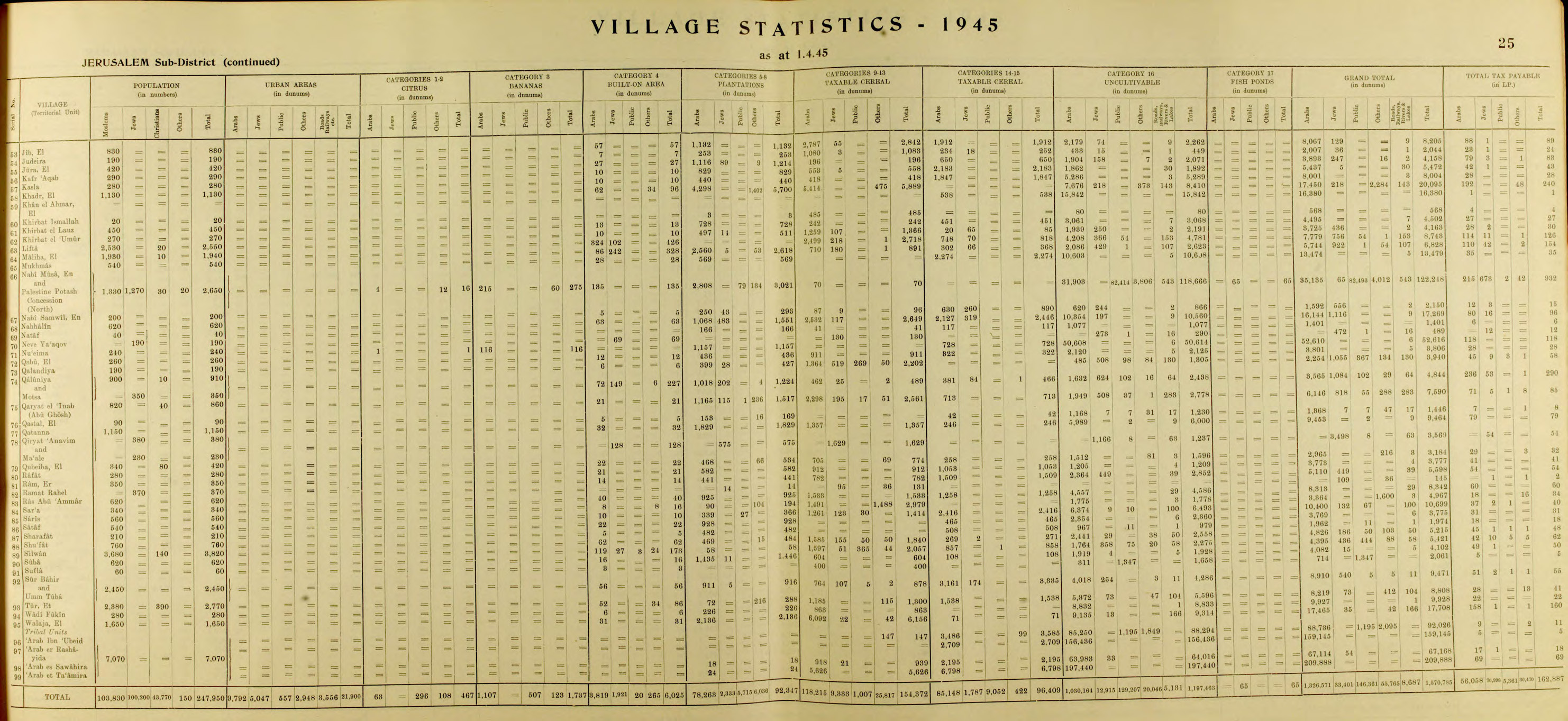
In the 1945 statistics the population of Sataf was 540, all Muslims,[4] and the total land area was 3,775 dunams, according to an official land and population survey.[3] Of this, 928 dunams were plantations and irrigable land, 465 for cereals,[17] while 22 dunams were built-up land.[18]
1948, aftermath
On July 13–14, 1948 the Arab village was depopulated by the Har'el Brigade, during Operation Danny.[19] Sataf and the surrounding area became part of the newly created State of Israel.
A short time after the 1948 War, a small group of Jewish immigrants from North Africa settled for a few months in the village area, calling it Bikura.[20] The village, which lasted only until the fall of 1950, was founded on the initiative of former Lehi commanded Natan Yellin-Mor.[20] Subsequently, the IDF's Unit 101 and paratroopers used the site for training purposes.[5]
In the 1980s the Jewish National Fund began the restoration of ancient agricultural terraces, and the area around the springs has been turned into a tourist site. A forest around the site was also planted by the Jewish National Fund.[21]
In 1992, Sataf was described as follows: "Many half-destroyed walls still stand, and some still have arched doorways. The walls of a few houses with collapsed roofs are almost intact....The area around the village spring, which is located to the east next to the ruins of a rectangular stone house, has been turned into an Israeli tourist site. A Jewish family has settled on the west side of the village, and have fenced in some of the village area."[19]
The shrine (maqam) of 'Ubayd, southwest of the village site, contains a courtyard and three rooms.[7] According to Tawfiq Canaan, Sheikh 'Ubayd "is said to kill any goat or sheep who enters his cave."[22]
- The hill (jabal) across from Sataf. September 1, 1945.
- Ein Sataf (Ein El-Balad), 2022
- Ein Sataf, 2009
- Ein Bikura (Ein E-Sharkia), 2022
- Ein Bikura, 2009
- Sataf reconstruction
- Agriculture in Sataf, 2009
- Remains of Sataf village
- Adar, Yael. "Ancient Agriculture: Sataf - A Reconstruction". Gems in Israel. Retrieved 27 November 2017.
- Toledano, 1984, pp. 280, 298. Toledano gives its location as 31°46′20″N 35°07′25″E
- Khalidi, 1992, p. 317
- Nir Hasson (23 June 2023). "This Murder Was Pinned on Palestinian Terrorists. Intelligence Docs Suggest They Were Jews". Haaretz.
- Sataf from the Khalil Sakakini Cultural Center
- Barron, J.B., ed. (1923). Palestine: Report and General Abstracts of the Census of 1922. Government of Palestine.
- Canaan, T. (1927). Mohammedan Saints and Sanctuaries in Palestine. London: Luzac & Co. Archived from the original on 2019-05-16. Retrieved 2015-04-09.
- Conder, C.R.; Kitchener, H.H. (1883). The Survey of Western Palestine: Memoirs of the Topography, Orography, Hydrography, and Archaeology. Vol. 3. London: Committee of the Palestine Exploration Fund.
- Government of Palestine, Department of Statistics (1945). Village Statistics, April, 1945.
- Guérin, V. (1869). Description Géographique Historique et Archéologique de la Palestine (in French). Vol. 1: Judee, pt. 2. Paris: L'Imprimerie Nationale.
- Hadawi, S. (1970). Village Statistics of 1945: A Classification of Land and Area ownership in Palestine. Palestine Liberation Organization Research Center.
- Hartmann, M. (1883). "Die Ortschaftenliste des Liwa Jerusalem in dem türkischen Staatskalender für Syrien auf das Jahr 1288 der Flucht (1871)". Zeitschrift des Deutschen Palästina-Vereins. 6: 102–149.
- Khalidi, W. (1992). All That Remains: The Palestinian Villages Occupied and Depopulated by Israel in 1948. Washington D.C.: Institute for Palestine Studies. ISBN 0-88728-224-5.
- Mills, E., ed. (1932). Census of Palestine 1931. Population of Villages, Towns and Administrative Areas. Jerusalem: Government of Palestine.
- Morris, B. (2004). The Birth of the Palestinian Refugee Problem Revisited. Cambridge University Press. ISBN 978-0-521-00967-6.
- Palmer, E.H. (1881). The Survey of Western Palestine: Arabic and English Name Lists Collected During the Survey by Lieutenants Conder and Kitchener, R. E. Transliterated and Explained by E.H. Palmer. Committee of the Palestine Exploration Fund.
- Petersen, Andrew (2001). A Gazetteer of Buildings in Muslim Palestine (British Academy Monographs in Archaeology). Vol. 1. Oxford University Press. ISBN 978-0-19-727011-0.
- Robinson, E.; Smith, E. (1841). Biblical Researches in Palestine, Mount Sinai and Arabia Petraea: A Journal of Travels in the year 1838. Vol. 3. Boston: Crocker & Brewster.
- Schick, C. (1896). "Zur Einwohnerzahl des Bezirks Jerusalem". Zeitschrift des Deutschen Palästina-Vereins. 19: 120–127.
- Socin, A. (1879). "Alphabetisches Verzeichniss von Ortschaften des Paschalik Jerusalem". Zeitschrift des Deutschen Palästina-Vereins. 2: 135–163.
- Toledano, E. (1984). "The Sanjaq of Jerusalem in the Sixteenth Century: Aspects of Topography and Population". Archivum Ottomanicum. 9: 279–319.
- Welcome To Sataf in Palestineremembered.com
- Sataf, from Zochrot
- Survey of Western Palestine, Map 17: IAA, Wikimedia commons
- Map, 1946