| Name |
Location |
Comments |
Date[note 1] |
Grid reference |
SM & HE numbers |
References |
Image |
| Aylestone Medieval Packhorse Bridge |
Aylestone |
Now 50m long, originally perhaps 200m. Also known as The 'Roman' bridge, Aylestone |
15th century? |
SK567009
52.603°N 1.1634°W / 52.603; -1.1634 (Aylestone Medieval Packhorse Bridge) |
SM00010
1003132 |
[3] |
 |
| Beaumont Leys Medieval Earthworks |
Castle Hill, Astill Lodge Road |
Includes remains of preceptory, mounds, fishpond and dam |
Medieval |
SK565092
52.6776°N 1.1658°W / 52.6776; -1.1658 (Beaumont Leys Medieval Earthworks) |
SM17095
1009196 |
[4] |
 |
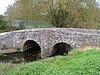
| Belgrave Bridge |
Thurcaston Road, Belgrave |
Six-arched bridge over the River Soar. Originally seven arches, but one was combined to give headroom for boats. Still used for traffic, but now limited to buses and bicycles only. A concrete footbridge on the south side, and a large sewage pipe on the north, mar its visual appearance. |
15th century? |
SK59050736
52.6607°N 1.1284°W / 52.6607; -1.1284 (Belgrave Bridge over River Soar) |
SM00031
1299667 |
[5] |
 |
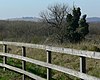
| Birds Nest Site |
Battersbee Road |
Lodge surrounded by a moat, now barely visible, and used as a recreation pitch. |
14th century |
SK552059
52.648035°N 1.1855458°W / 52.648035; -1.1855458 (Birds Nest Site) |
SM17027
1010664 |
[6] |
 |
| The Hollow |
Evington |
Moated medieval manorial complex with fishponds |
Medieval |
SK626027
52.61847°N 1.0767894°W / 52.61847; -1.0767894 (The Hollow) |
SM17026
1010686 |
[7] |
 |
| Jewry Wall and nearby remains |
St Nicholas Circle |
Roman remains, some of which are incorporated into St Nicholas' Church, Leicester |
Roman, Anglo-Saxon |
SK582044
52.634239°N 1.1414732°W / 52.634239; -1.1414732 (Jewry Wall and nearby remains) |
SM17154
1013312 |
[8] |
 |
| King William's Bridge |
Sheepwash Lane, Anstey, Leicestershire |
Two-arch packhorse bridge |
17th century? |
SK556089
52.67496°N 1.1791293°W / 52.67496; -1.1791293 (King William's Bridge) |
SM00195
1003568 |
[9] |
 |
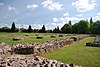
| Leicester Abbey |
Abbey Park |
Includes the Abbey Ruins, Abbot Penny's Wall, Cavendish House and Ornamental Gardens |
From 12th century |
SK583058
52.646812°N 1.139749°W / 52.646812; -1.139749 (Leicester Abbey) |
SM17131
1012149 |
[10] |
 |
| Leicester Castle and the Magazine Gateway |
Castle Yard, Castle Park, The Newarke |
Includes the Castle Mound, Turret Gateway, Great Hall, 'Dungeon'/John of Gaunt's cellar, and the Magazine Gateway |
Medieval |
SK582041
52.631542°N 1.141526°W / 52.631542; -1.141526 (Leicester Castle and the Magazine Gateway) |
SM17127
1012147 |
[11] |
 |
| Raw Dykes |
Aylestone Road |
Purpose uncertain: possibly Roman Aqueduct[12] |
Roman |
SK583026
52.618049°N 1.1403129°W / 52.618049; -1.1403129 (Raw Dykes) |
SM30218
1017391 |
[13] |
 |
|


.svg)