Serinhisar
Serinhisar
District and municipality in Denizli, Turkey
Serinhisar is a municipality and district of Denizli Province, Turkey.[2] Its area is 256 km2,[3] and its population is 14,355 (2022).[1]
This article needs additional citations for verification. (April 2015) |
Serinhisar | |
|---|---|
District and municipality | |
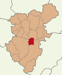
 Map showing Serinhisar District in Denizli Province | |
| Coordinates: 37°34′50″N 29°16′11″E | |
| Country | Turkey |
| Province | Denizli |
| Government | |
| • Mayor | Hüseyin Gemi (CHP) |
| Area | 256 km2 (99 sq mi) |
| Elevation | 941 m (3,087 ft) |
| Population (2022)[1] | 14,355 |
| • Density | 56/km2 (150/sq mi) |
| Time zone | UTC+3 (TRT) |
| Postal code | 20430 |
| Area code | 0258 |
| Website | www |
Other names include Karia (in Latin) and Kızılhisar (literally "a red castle"). The latter is the name given by the Seljuk Turks as there were brick built fortifications here. The name was changed to Serinhisar (literally "a cool castle") in 1987, apparently because red castle was too symbolic of communism.
The area was first settled by the Hittites in 1500 BC, and later passed into the hands of the Lydians (800 BC), Persians (546 BC), Ancient Greeks (440 BC), Ancient Macedonians (334 BC) and Romans (133 BC). When the Roman Empire was divided in 395 the area remained within the Eastern Roman Empire (Byzantine) and was then possessed by the Seljuk Turks in 1077, who ruled until 1308. Turkmens (from Oghuz Turks' Avsar and Kayi tribe) were settled in the district in this period. Seljuk rule was interrupted by the Crusades, Genghis Khan, and Timurlane, who left the area under the rule of the Germiyan dynasty, from whom it passed to the Ottoman Empire in 1429. The castle fell into ruin in the Ottoman period and was broken up for building materials, being finally demolished in 1954.
The battle of Kazıkbeli
During the Second Crusade in 1148 the French king was proceeding eastwards having crossed the Menderes River but was stalled at the pass of Kazıkbeli, near Kızılhisar, by the Seljuk armies.
There are 11 neighbourhoods in Serinhisar District:[4]
- Aşağı
- Ayaz
- Cumhuriyet
- Kaya
- Kocapınar
- Orta
- Pınarcık
- Şair Eşref
- Yatağan
- Yenice
- Yüreğil
Today Serinhisar is known for its leblebi (roasted chick peas), pottery, ropemaking and shoemaking. This is a rural area and its people are hospitable and warmblooded.
- "Address-based population registration system (ADNKS) results dated 31 December 2022, Favorite Reports" (XLS). TÜİK. Retrieved 12 July 2023.
- Büyükşehir İlçe Belediyesi, Turkey Civil Administration Departments Inventory. Retrieved 12 July 2023.
- "İl ve İlçe Yüz ölçümleri". General Directorate of Mapping. Retrieved 12 July 2023.
This geographical article about a location in Denizli Province, Turkey is a stub. You can help Wikipedia by expanding it. |

