Ulanhot

Ulanhot

Ulanhot

City in Inner Mongolia, China


Ulanhot (Mongolian: ᠤᠯᠠᠭᠠᠨᠬᠣᠲᠠ; Chinese: 乌兰浩特), alternatively Ulaγanqota (Red City) in Classical Mongolian, is a county-level city and the administrative center of Hinggan League in the east of the Inner Mongolia, China. Formerly known as Wangin Süm (Wang-un Süme, Wangyehmiao, Wangyemiao, ᠸᠠᠩ ᠤᠨ ᠰᠦᠮ᠎ᠡ᠎, Chinese: 王爺廟), the city became the first capital of Inner Mongolia, the first autonomous region in China, on 1 May 1947,[3] until the regional capital moved to Zhangjiakou in late December 1949; the regional capital moved again in June 1952 to Hohhot, which remains the capital to this day.[4]

Quick Facts 乌兰浩特市 • ᠤᠯᠠᠭᠠᠨᠬᠣᠲᠠ, Country ...
Quick Facts Chinese name, Simplified Chinese ...
Quick Facts Former name, Alternative Chinese name ...

The city is connected to Baicheng, Jilin by the Baicheng–Arxan railway (Chinese: 白阿铁路), which runs through the pass south of Ulanhot[citation needed]. China's National Highway 302 runs from Tumen, Jilin to Ulanhot. In the 7918 Network of Highways it will be on the route from Hunchun to Ulanhot [clarification needed]. The city is also served by Ulanhot Yilelite Airport (ICAO code ZBUL, IATA code HLH). Routes flown by Air China and Hainan Airlines connect Ulanhot with Beijing Capital International Airport and Hohhot.

Just outside the city is a tomb from the Yuan dynasty and a temple dedicated to Genghis Khan. The temple was constructed in 1940. In the year 2002 it received funds for significant expansion.[5]

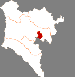
Administrative divisions

Ulanhot is divided into 10 subdistricts and 4 towns.

More information Name, Simplified Chinese ...

Others:

  • Hoh Horse Herding Pasture (呼和马场)
  • Ulanhot Green Industrial Park (乌兰浩特绿色产业园)
  • Hinggan League Economic-Technological Development Area (兴安盟经济技术开发区)

Climate

Ulan Hot has a monsoon-influenced humid continental climate (Köppen Dwa). Winters are long, cold and dry, while summers are very warm. The monthly 24-hour mean temperature ranges from −15.0 °C (5.0 °F) in January to 22.9 °C (73.2 °F) in July, and the annual mean is 5.03 °C (41.1 °F). Over two-thirds of the annual rainfall occurs from May to August.

Quick Facts Ulan Hot, Climate chart (explanation) ...
More information Climate data for Ulan Hot (1991–2020 normals, extremes 1971–2000), Month ...

Education

Secondary schools in Ulanhot include:[9]

  • Ulanhot No. 1 (乌兰浩特第一中学)
  • Ulanhot No. 2 (乌兰浩特第二中学)
  • Ulanhot No. 3 (乌兰浩特第三中学)

Transportation


References

  1. Ministry of Housing and Urban-Rural Development, ed. (2019). China Urban Construction Statistical Yearbook 2017. Beijing: China Statistics Press. p. 48. Retrieved 11 January 2020.
  2. Wang, Zhanyi (王占义); Shi, Ye (史叶) (2017-07-06). 1947年内蒙古自治政府在兴安盟成立-中国社会科学网. Chinese Academy of Social Sciences. Retrieved 2020-05-12.
  3. 内蒙古统一的民族区域自治的实现. Xinhua Inner Mongolia. Retrieved 2020-05-12.
  4. 中国气象数据网 – WeatherBk Data (in Simplified Chinese). China Meteorological Administration. Retrieved 10 October 2023.
  5. "Experience Template" 中国气象数据网 (in Simplified Chinese). China Meteorological Administration. Retrieved 10 October 2023.
  6. 乌兰浩特 - 气象数据 -中国天气网 (in Chinese). Weather China. Retrieved 10 October 2023.
  7. "中考专栏". Xing An Meng Education. Retrieved 2024-02-08. - The .gov.cn shows this is a government site.

Share this article:

This article uses material from the Wikipedia article Ulanhot, and is written by contributors. Text is available under a CC BY-SA 4.0 International License; additional terms may apply. Images, videos and audio are available under their respective licenses.