Virginia_State_Route_288
Virginia State Route 288
State highway in Virginia, United States
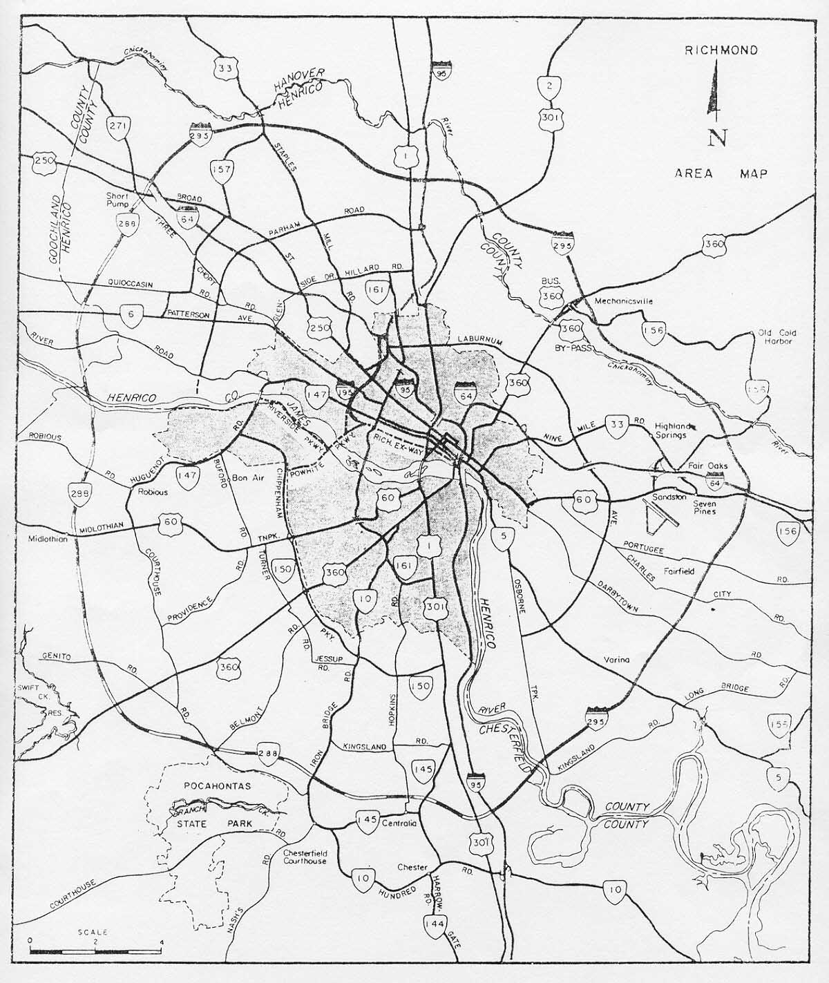
State Route 288 is a primary state highway in the U.S. state of Virginia. It is a freeway-standard partial beltway around the southwest side of the Richmond, Virginia metropolitan area in portions of Goochland, Powhatan, and Chesterfield counties. SR 288 was officially dedicated as the World War II Veterans Memorial Highway in 2004.
This article needs additional citations for verification. (September 2016) |
State Route 288 | ||||
|---|---|---|---|---|
| World War II Veterans Memorial Highway | ||||
 | ||||
| Route information | ||||
| Maintained by VDOT | ||||
| Length | 31.77 mi[1] (51.13 km) | |||
| Major junctions | ||||
| South end | ||||
| Major intersections |
| |||
| North end | ||||
| Location | ||||
| Country | United States | |||
| State | Virginia | |||
| Counties | Chesterfield, Powhatan, Goochland | |||
| Highway system | ||||
| ||||

_just_north_of_Huguenot_Trail_(Virginia_State_Secondary_Route_711)_in_eastern_Powhatan_County,_Virginia.jpg)
SR 288 may be thought of as the southwestern portion of an "outer beltway" of Richmond, although there is no such roadway formally designated. The route begins at Interstate 95 north of Chester, and extends northwesterly through Chesterfield County and Powhatan County. It crosses the James River on the World War II Veterans Memorial Bridge into Goochland County in Richmond's Far West End area, where it terminates at Interstate 64 near Short Pump, near the northern terminus of Interstate 295.
The highway has been built entirely to Interstate standards.[2]
In 1968, Congress passed the Federal-Aid Highway Act of 1968, which expanded the Interstate Highway System by 1,500 miles (2,400 km). The Commonwealth Transportation Board (CTB) resolved in its August 1968 meeting to apply to the American Association of State Highway and Transportation Officials (AASHTO) for approval of five new stretches of Interstate. Three of these – the future I-195 and I-664 plus an expansion of the Berkley Bridge on I-264 – were submitted and approved. The other two presumably received no further action because they are not in AASHTO's records; these are today SR 288 and SR 164. [3][4]
Sections of the road were built over a period of more than 15 years. During that time, the planned routing of the northern portion was changed substantially, and not without some conflict within the communities. The 17.4-mile-long southern portion of SR 288 in Chesterfield County (from Interstate 95 to State Route 76 near Midlothian) was completed in 1989.
Initially, the highway was planned to continue north and west of this temporary terminus to connect with Interstate 64 at Interstate 295, creating a seamless straight connection between SR 288 and I-295. This would have formed a partial beltway (I-295 north of I-64 and east of I-95, and SR 288 in the southwest quadrant).[5]
However, this planned corridor and a river crossing into Henrico County west of Richmond was abandoned in 1988. This was due to a peculiarity in the varying powers and abilities of local governments to control growth and preserve rights-of-way resultant from the Byrd Road Act of 1932. While Henrico County had been able to preserve its corridor, there had been development of residential neighborhoods and homes along and within the intended path in Chesterfield County during the years after initial planning. Despite opposition by both Henrico County and the City of Richmond, a more westerly alignment north of SR 76 was selected. Much of the planned section in Henrico County became the John Rolfe Parkway corridor there.
Instead, a more westerly alignment was selected through Powhatan and Goochland Counties, causing a break in what would have been a continuous loop between SR 288 and I-295 at their northern juncture. In 2004, construction of this "western alignment" as it became known was completed, including a new crossing of the James River known as the World War II Veterans Memorial Bridge.
Henrico County was able to preserve its planned corridor for Route 288 from development while Chesterfield County was not. This was partially because Henrico and Arlington County are the only two counties in Virginia which control and maintain their own secondary highways and streets. VDOT handles this for Chesterfield and all other counties, but has little control of residential development.
This section is missing mileposts for junctions. |
All exits are unnumbered.
| County | Location | mi[1] | km | Destinations | Notes |
|---|---|---|---|---|---|
| Chesterfield | | 0.00 | 0.00 | Southern terminus; exit 62 (I-95); trumpet interchange | |
| | 0.48 | 0.77 | Cloverleaf interchange | ||
| Centralia | 2.01 | 3.23 | Diamond interchange | ||
| | 5.89 | 9.48 | Cloverleaf interchange | ||
| Five Forks | 8.84 | 14.23 | Diamond interchange Former VA 106 | ||
| | no northbound exit | ||||
| | 12.93 | 20.81 | Cloverleaf interchange | ||
| | 15.72 | 25.30 | Cloverleaf interchange with collector-distributor lanes | ||
| | Diamond interchange | ||||
| | 18.47 | 29.72 | Diamond interchange | ||
| | Southbound access only | ||||
| | 20.24 | 32.57 | Cloverleaf interchange with collector-distributor lanes | ||
| | Watkins Centre Parkway (SR 7225) | Southbound access only | |||
| Powhatan | | 23.70 | 38.14 | Diamond interchange; former SR 44 | |
| James River | 25.24 | 40.62 | World War II Veterans Memorial Bridge | ||
| Goochland | | 26.81 | 43.15 | Cloverleaf interchange; no direct access from SR 288 south to SR 6 west | |
| | 27.45 | 44.18 | Partial cloverleaf interchange | ||
| | 29.13 | 46.88 | Cloverleaf interchange; flyover ramps from southbound SR 288 to Capital One Drive and from Capital One Drive to northbound SR 288 | ||
| | 30.92 | 49.76 | interchange | ||
| | 31.77 | 51.13 | Northern terminus; exit 175 (I-64); semi-directional T interchange | ||
| 1.000 mi = 1.609 km; 1.000 km = 0.621 mi | |||||
- "2012 Traffic Data". Virginia Department of Transportation. 2012. Retrieved 2014-01-21.
- State Highway Commission of Virginia (August 16, 1968). "Minutes of Meeting" (PDF) (Report). Richmond: Commonwealth of Virginia. pp. 41–42.
- Special Committee on U.S. Route Numbering (n.d.). "USRN Application Database with Meeting Minutes and Application Results". American Association of State Highway and Transportation Officials. Retrieved November 10, 2016.