Barahona_Province

Barahona Province

Barahona Province

Province of the Dominican Republic


Barahona (Spanish pronunciation: [baɾaˈona]) is a province of the Dominican Republic. Located in the country's southwestern region, it is dividing into 11 municipalities and its capital bears the city of the same name. Barahona borders the provinces of Pedernales to the southwest, Baoruco and Independencia to the north, and Azua to the east along with coastline to the south with the Caribbean Sea. The province has an approximately three hours drive from Santo Domingo the capital of the Dominican Republic. In 2019, volunteers from Amigos de las Americas visited to facilitate projects within the various municipalities of Barahona.[2]
Quick Facts Country, Province since ...

Municipalities and municipal districts

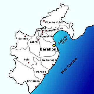
Municipalities of Barahona Province.
Barahona Dominican Republic downtown streets.

The province as of June 20, 2006 is divided into the following municipalities (municipios) and municipal districts (distrito municipal - D.M.) within them:[3]

Sea Cliff on Caribbean coast near El Quemaíto, Barahona Province, Dominican Republic.

The following is a sortable table of the municipalities and municipal districts with population figures as of the 2014 estimate. Urban population are those living in the seats (cabeceras literally heads) of municipalities or of municipal districts. Rural population are those living in the districts (Secciones literally sections) and neighborhoods (Parajes literally places) outside them. The population figures are from the 2014 population estimate.[4]

More information Name, Total population ...

For comparison with the municipalities and municipal districts of other provinces see the list of municipalities and municipal districts of the Dominican Republic.


References

  1. Consejo Nacional de Población y Familia. "Estamaciones y Proyecciones de la Población Dominicana por Regiones, Provincias, Municipios y Distritos Municipales, 2014" (PDF) (in Spanish). Retrieved 2014-02-02.
  2. "Listado de Codigos de Provincias, Municipio y Distritos Municipales, Actualizada a Junio 20 del 2006". Oficina Nacional de Estadistica, Departamento de Cartografia, Division de Limites y Linderos (in Spanish). Archived from the original on August 3, 2007. Retrieved 2007-01-24.

Share this article:

This article uses material from the Wikipedia article Barahona_Province, and is written by contributors. Text is available under a CC BY-SA 4.0 International License; additional terms may apply. Images, videos and audio are available under their respective licenses.