|
Description
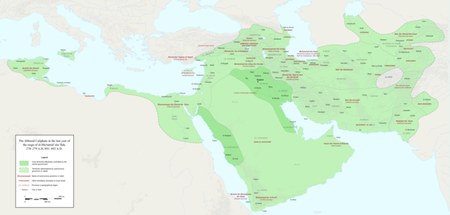
Abbasid Caliphate 891-892.png
|
English:
Map of the Abbasid Caliphate at the end of the reign of al-Mu'tamid in 891-892. Dark green denotes provinces under the effective control of the central government; light green denotes provinces under the control of autonomous governors or rebels.
The core Abbasid territories include Shahrazur, Darabadh, al-Samaghan, Hulwan, Masabadhan, Mihrijanqadhaq, the Euphrates districts, and Qarqisiyya (al-Tabari v. 37, p. 98; Bianquis p. 96).
Map originally created as an .SVG file in Inkscape and converted to .PNG for size reasons.
Background topography taken from
DEMIS Mapserver
, which are public domain.
Works Cited:
-
Baloch, N.A., and A.Q. Rafiqi. "The regions of Sind, Baluchistan, Multan and Kashmir: the historical, social and economic setting."
History of Civilizations of Central Asia, Volume IV: The Age of Achievement: AD 750 to the End of the Fifteenth Century.
-
Barthold, W.
Turkestan Down to the Mongol Invasion.
Trans. V. Minorskey. Taipei: Southern Materials Center, 1988.
-
Bianquis, Thierry. "Autonomous Egypt from ibn Tulun to Kafur, 868-969."
The Cambridge History of Egypt, Volume 1: Islamic Egypt, 640-1517.
Ed Carl F. Petry. Cambridge, UK: Cambridge University Press, 1998. 0-521-47137-0
-
Bosworh, C.E. "The City of Tarsus and the Arab-Byzantine Frontiers in Early and Middle 'Abbasid Times."
Oriens,
Vol. 33, 1992, pp. 268-286.
-
-------
The History of the Saffarids of Sistan and the Maliks of Nimruz (247/861 to 949/1542-3)
. Costa Mesa, California: Mazda Publishers, 1994.
ISBN
1-56859-015-6
-
Bregel, Yuri.
An Historical Atlas of Central Asia.
Leiden and Boston: Brill, 2003.
ISBN
90-04-12321-0
-
Encyclopaedia Iranica.
Vol. I-. London, 1982-.
-
The Encyclopaedia of Islam.
New Ed. 12 vols. with supplement and indices. Leiden: E.J. Brill, 1960-2005. (for most of the localities on the map)
-
"Europe in the Year 900."
Euratlas.
Accessed 3 December 2017.
-
Frye, Richard N.
The Cambridge History of Iran, Vol. 4: The Period from the Arab Invasion to the Saljuqs.
Cambridge: Cambridge University Press, 1975.
ISBN
978-0-521-20093-6
(text and maps)
-
Hamdani, Abbas. "History of Surt."
Excavations at Surt (Medinat al-Sultan) between 1977 and 1981.
Ed. Elizabeth Savage. London: Department of Antiquities, 2002.
-
Kennedy, Hugh, ed.
An Historical Atlas of Islam.
Boston: Brill Academic, 2002.
ISBN
90-04-12235-4
-
Le Strange, Guy.
The Lands of the Eastern Caliphate: Mesopotamia, Persia, and Central Asia, from the Moslem conquest to the time of Timur.
Cambridge: Cambridge University Press, 1905.
-
"Maps."
Armenica.
Accessed 3 December 2017.
-
Al-Muqaddasi, Muhammad ibn Ahmad.
The Best Divisions for Knowledge of the Regions.
Trans. Basil Collins. Reading: Garner Publishing Limited, 2001.
ISBN
1-85964-136-9
-
Al-Tabari, Abu Ja'far Muhammad ibn Jarir.
The History of al-Tabari, Volume XXXVII: The 'Abbasid Recovery.
Trans. Philip M. Fields. Ed. Ehsan Yar-Shater. Albany, NY: State University of New York Press, 1985.
ISBN
0-88706-054-4
-
-------
The History of al-Tabari, Volume XXXVIII: The Return of the Caliphate to Baghdad.
Trans. Franz Rosenthal. Ed. Ehsan Yar-Shater. Albany, NY: State University of New York Press, 1985.
ISBN
0-87395-876-4
-
Ter-Ghewondyan, Aram.
The Arab Emirates in Bagratid Armenia.
Trans. Nina G. Garsoïan. Lisbon: Livraria Bertrand, 1976.
|

