After_Bombing_of_Tokyo_on_March_1945_19450310.jpg

Size of this preview:
800 × 507 pixels
.
Other resolutions:
320 × 203 pixels
|
640 × 406 pixels
|
1,000 × 634 pixels
.
Summary
| Description |
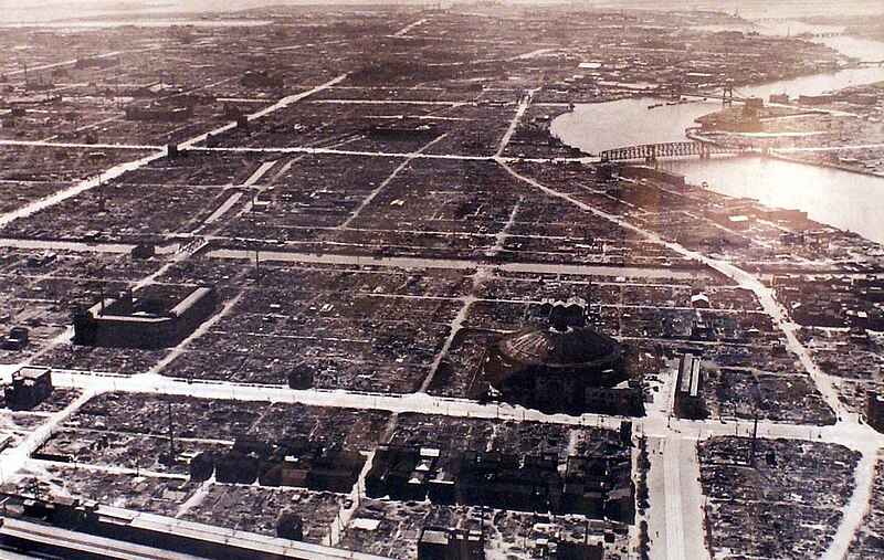
日本語:
空襲により焦土と化した東京。
両国駅
付近上空から南に向かい撮影。画面一番下が国鉄両国駅、中央右の大きなドーム状の建物は旧
両国国技館
(現在は両国シティコアとなっており、新国技館の位置とは異なる)、その前を左右に走るのは
京葉道路
、右奥が
隅田川
、見えている橋は手前から
トラス橋
時代の
新大橋
(一部は
博物館明治村
にて保存)と
吊り橋
時代の
清洲橋
。
English:
Tokyo was scorched by air raids. Taken from the sky near Ryogoku Station to the south. The bottom of the photo is Ryogoku Station, the large dome-shaped building on the right of the center is the old Ryogoku Kokugikan (currently Ryogoku City Core, which is different from the location of the new Kokugikan), and running left and right in front of it Keiyo road, at the far right is the Sumida River, visible and a bridge from the front truss bridge of the Shin'ohashi era (some of Meiji-mura stored at) and the suspension bridge of the Kiyosubashi era.
|
| Date | Taken on 10 March 1945 |
| Source | http://www.kmine.sakura.ne.jp/kusyu/kuusyu.html |
| Author | U.S. military photography (米軍撮影) |
Licensing
|
|
This photograph is in the
public domain
in
Japan
because its copyright has expired according to Article 23 of the 1899
Copyright Act
of Japan (
English translation
) and Article 2 of Supplemental Provisions of
Copyright Act
of 1970. This is when the photograph meets one of the following conditions:
|

|

|
To uploader:
Please provide the source and
publication date
.
|