Ancient_Levant_routes.png

Size of this preview:
800 × 541 pixels
.
Other resolutions:
320 × 217 pixels
|
640 × 433 pixels
|
919 × 622 pixels
.
Summary
| Description |
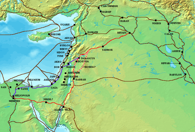
The en:Via Maris (purple), King's Highway (in red), and other ancient en:Levantine en:trade routes , c. en:1300 BCE en:Category:Historical maps by User:Briangotts |
| Date | 24 May 2006 (original upload date) |
| Source | Transferred from en.wikipedia to Commons. |
| Author | Briangotts at English Wikipedia |
Licensing
Briangotts
at the
English Wikipedia
, the copyright holder of this work, hereby publishes it under the following license:

|
Permission is granted to copy, distribute and/or modify this document under the terms of the GNU Free Documentation License , Version 1.2 or any later version published by the Free Software Foundation ; with no Invariant Sections, no Front-Cover Texts, and no Back-Cover Texts. A copy of the license is included in the section entitled GNU Free Documentation License . |
|
|
This file is licensed under the Creative Commons Attribution-Share Alike 3.0 Unported license. | |
| Attribution: Briangotts at the English Wikipedia | ||
|
||
| This licensing tag was added to this file as part of the GFDL licensing update . |
Original upload log
The original description page was
here
. All following user names refer to en.wikipedia.
- 2006-05-24 18:48 Briangotts 919×622×8 (326236 bytes) The [[Via Maris]] (purple), [[King's Highway (ancient)|King's Highway]] (in red), and other ancient [[Levant]]ine [[trade route]]s, c. 1300 BCE]] [[Category:Historical maps by User:Briangotts]]
ATTENTION, il semble que la carte soit fausse, car la vraie Bosra est bien plus a l'Est (voir ma discussion)