Andaman_nicobar_76.jpg

Size of this preview:
259 × 599 pixels
.
Other resolutions:
103 × 240 pixels
|
207 × 480 pixels
|
894 × 2,068 pixels
.
Summary
| Description |
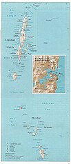
English:
Map of the Nicobar and Andaman Islands.
|
| Date | |
| Source | Courtesy of the University of Texas Libraries, The University of Texas at Austin. Reproduced from the Perry-Castañeda Library Map Collection of the University of Texas, Austin; originally from The Indian Ocean Atlas, produced and published (1976) by the U.S. Central Intelligence Agency. |
| Author | Pyramide~commonswiki |
|
Permission
( Reusing this file ) |
This material is in the public domain according to notes at Indian Ocean Maps and The UT Library Web Material Usage Statement |

|
File:Map of Nicobar and Andaman Islands-en.svg
is a vector version of this file. It should be used in place of this JPG file when not inferior.
File:Andaman nicobar 76.jpg →
File:Map of Nicobar and Andaman Islands-en.svg
For more information, see
Help:SVG
.
|

|
Licensing
|
|
This image is a work of a
Central Intelligence Agency
employee, taken or made as part of that person's official duties. As a Work of the United States Government, this image or media is in the
public domain
in the United States.
|

|