Armenian_Genocide_Map-en.svg

Size of this PNG preview of this SVG file:
800 × 393 pixels
.
Other resolutions:
320 × 157 pixels
|
640 × 314 pixels
|
1,024 × 503 pixels
|
1,280 × 629 pixels
|
2,560 × 1,257 pixels
|
2,574 × 1,264 pixels
.
Summary
| Description |
English
:
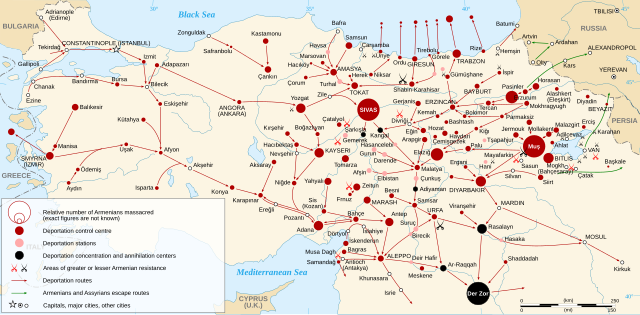
Map of the
Armenian Genocide
in 1915.
Español
:
Mapa del
genocidio armenio
en 1915.
Français
:
Carte en anglais du
génocide arménien
de 1915.
Русский
:
Карта
геноцида армян
1915 года.
|
| Date | |
| Source |
Other data :
|
| Author | Sémhur |
| Other versions |
[
]
|
| SVG development |
|


| Camera location |
|
View this and other nearby images on: OpenStreetMap |
|
|---|
Assessment
|
Licensing
I, the copyright holder of this work, hereby publish it under the following licenses:

|
Permission is granted to copy, distribute and/or modify this document under the terms of the GNU Free Documentation License , Version 1.2 or any later version published by the Free Software Foundation ; with no Invariant Sections, no Front-Cover Texts, and no Back-Cover Texts. A copy of the license is included in the section entitled GNU Free Documentation License . |
This file is licensed under the
Creative Commons
Attribution-Share Alike
3.0 Unported
,
2.5 Generic
,
2.0 Generic
and
1.0 Generic
license.
-
You are free:
- to share – to copy, distribute and transmit the work
- to remix – to adapt the work
-
Under the following conditions:
- attribution – You must give appropriate credit, provide a link to the license, and indicate if changes were made. You may do so in any reasonable manner, but not in any way that suggests the licensor endorses you or your use.
- share alike – If you remix, transform, or build upon the material, you must distribute your contributions under the same or compatible license as the original.
You may select the license of your choice.