Cave_lion_range.png
No higher resolution available.

|
This
map of the world
image could be re-created
using
vector graphics
as an
SVG
file
. This has several advantages; see
Commons:Media for cleanup
for more information. If an SVG form of this image is available, please upload it and afterwards replace this template with
{{

vector version available

|

new image name

}}
.
It is recommended to name the SVG file “Cave lion range.svg”—then the template Vector version available (or Vva ) does not need the new image name parameter. |
Summary
| Description |
English:
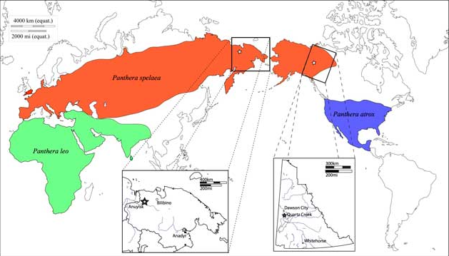
A map of the approximate distributions of late Pleistocene lions. Red indicates the maximal range of Panthera spelaea; blue the maximal range of Panthera atrox; and green the maximal range of Panthera leo leo/Panthera leo persica. L. Stars show approximate locations of lion samples. The insets show details of the modern boundaries of Yukon Territory, Canada, and Chukotka, Russia, along with regional settlements.
|
| Date | |
| Source | Barnett, R. et al., (2016). Mitogenomics of the Extinct Cave Lion, Panthera spelaea (Goldfuss, 1810), Resolve its Position within the Panthera Cats. Open Quaternary. 2, p.4. DOI: http://doi.org/10.5334/oq.24 |
| Author | Ross Barnett, Marie Lisandra Zepeda Mendoza, André Elias Rodrigues Soares, Simon Y W Ho, Grant Zazula, Nobuyuki Yamaguchi, Beth Shapiro, Irina V Kirillova, Greger Larson, M Thomas P Gilbert |
Licensing
This file is licensed under the
Creative Commons
Attribution-Share Alike 3.0 Unported
license.
-
You are free:
- to share – to copy, distribute and transmit the work
- to remix – to adapt the work
-
Under the following conditions:
- attribution – You must give appropriate credit, provide a link to the license, and indicate if changes were made. You may do so in any reasonable manner, but not in any way that suggests the licensor endorses you or your use.
- share alike – If you remix, transform, or build upon the material, you must distribute your contributions under the same or compatible license as the original.