Chagatai_Khanate_(1490).png

Size of this preview:
800 × 451 pixels
.
Other resolutions:
320 × 180 pixels
|
640 × 360 pixels
|
1,202 × 677 pixels
.
Summary
| Description |
English:
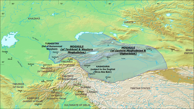
A map of the Moghul
Chagatai Khanate
in 1490 CE. Note: This map is compressed in vertical direction. Please, expand it about 1.3 times to see it undistorted.
ReferencesInformation for the borders of the Moghul khanate came mostly from these two sources:
|
| Date | 22 July 2008 (original upload date) |
| Source | Transferred from en.wikipedia to Commons by Betta27 . |
| Author | Ro4444 at English Wikipedia |
Licensing
Ro4444
at the
English Wikipedia
, the copyright holder of this work, hereby publishes it under the following license:

|
Permission is granted to copy, distribute and/or modify this document under the terms of the GNU Free Documentation License , Version 1.2 or any later version published by the Free Software Foundation ; with no Invariant Sections, no Front-Cover Texts, and no Back-Cover Texts. A copy of the license is included in the section entitled GNU Free Documentation License . |
|
|
This file is licensed under the Creative Commons Attribution-Share Alike 3.0 Unported license. | |
| Attribution: Ro4444 at the English Wikipedia | ||
|
||
| This licensing tag was added to this file as part of the GFDL licensing update . |
Original upload log
The original description page was
here
. All following user names refer to en.wikipedia.
- 2008-07-22 06:20 Ro4444 1202×677× (811049 bytes) {{Information |Description={{en|1=A map of the Moghul (Chagatai) Khanate in 1490}} |Source=Own work by uploader |Author=ro4444 |Date=22 July 2008 |Permission= |other_versions= }} {{ImageUpload|full}} ==References== Information for the borders of the Mog
]]