Externsteine_pano.jpg

Size of this preview:
800 × 438 pixels
.
Other resolutions:
320 × 175 pixels
|
640 × 350 pixels
|
1,024 × 561 pixels
|
1,280 × 701 pixels
|
2,560 × 1,402 pixels
|
4,018 × 2,200 pixels
.
Summary
|
|
|
This image was selected as
picture of the day
on Wikimedia Commons for
30 June 2007
. It was captioned as follows:
Other languages:
Deutsch
:
Die
Externsteine
im Teutoburger Wald bei Horn-Bad Meinberg.
Español
:
Vista de las formaciones rocosas de
Externsteine
, en el
bosque teutónico
, cercano a Horn-Bad Meinberg,
Alemania
.
Italiano
:
La formazione rocciosa delle
Externsteine
, nella
foresta di Teutoburgo
vicino a
Horn-Bad Meinberg
,
Germania
.
Polski
:
Externsteine
- kompleks skał pochodzenia kredowego, Niemcy
Português
:
Vista das
Externsteine
na
Floresta de Teutoburgo
próximo a
Horn-Bad Meinberg
, na
Alemanha
.
Беларуская
:
Комплекс скальных фармацый Экстэрштайн (
Externsteine
) у Тэўтанбургскім лесе ля Хорн–Бад Майнберг (Германія)
|
| Camera location |
|
View this and other nearby images on: OpenStreetMap |
|
|---|
| Description |
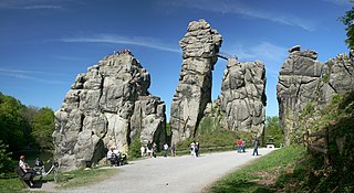
Deutsch:
Externsteine
im Teutoburger Wald bei Horn-Bad Meinberg
English:
Externsteine in Teutoburg Forrest near Horn-Bad Meinberg
Français :
Formations rocheuses nommées Externsteine dans la
forêt de Teutberg
, près de Horn-Bad Meinberg, dans la
Rhénanie-du-Nord-Westphalie
(Allemagne).
|
| Date | |
| Source | Own work |
| Author | Daniel Schwen |
| Other versions |
|
Licensing
I, the copyright holder of this work, hereby publish it under the following license:
This file is licensed under the
Creative Commons
Attribution-Share Alike 2.5 Generic
license.
-
You are free:
- to share – to copy, distribute and transmit the work
- to remix – to adapt the work
-
Under the following conditions:
- attribution – You must give appropriate credit, provide a link to the license, and indicate if changes were made. You may do so in any reasonable manner, but not in any way that suggests the licensor endorses you or your use.
- share alike – If you remix, transform, or build upon the material, you must distribute your contributions under the same or compatible license as the original.