First_satellite_photo_-_Explorer_VI.jpg

Size of this preview:
440 × 600 pixels
.
Other resolutions:
176 × 240 pixels
|
352 × 480 pixels
|
563 × 768 pixels
|
751 × 1,024 pixels
|
2,212 × 3,016 pixels
.
Summary
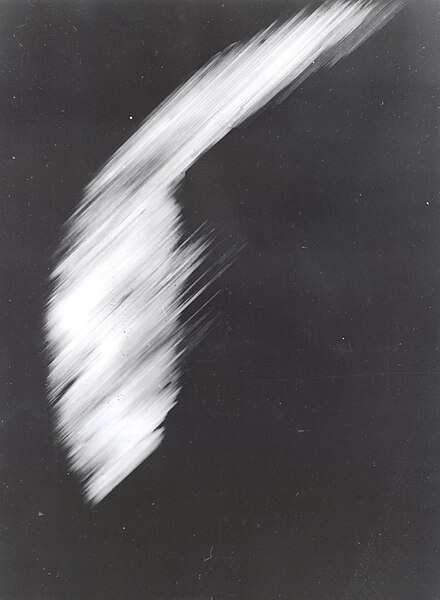
| Description | The first photo of Earth from a satellite in orbit. This is the first crude picture obtained from Explorer VI Earth satellite launched August 7, 1959. It shows a sun-lighted area of the Central Pacific ocean and its cloud cover. The picture was made when the satellite was about 17,000 miles above the surface of the earth on August 14, 1959. At the time, the satellite was crossing Mexico. The signals were received at the South Point, Hawaii, tracking station. |
| Date | |
| Source | http://grin.hq.nasa.gov/ABSTRACTS/GPN-2002-000200.html |
| Author | NASA, Explorer VI satellite |
|
Permission
( Reusing this file ) |
Public domain |
|
|
This image or video was catalogued by NASA Headquarters of the United States
National Aeronautics and Space Administration
(NASA) under
Photo ID:
GPN-2002-000200
and
Alternate ID:
59-EX-16A-VI
.
This tag does not indicate the copyright status of the attached work. A normal copyright tag is still required. See Commons:Licensing .
Other languages:
|
Licensing
|
|
This file is in the public domain in the United States because it was solely created by NASA . NASA copyright policy states that "NASA material is not protected by copyright unless noted ". (See Template:PD-USGov , NASA copyright policy page or JPL Image Use Policy .) |
|

|
Warnings:
|