Historische_Karte_CH_Rome_1.png

Size of this preview:
800 × 510 pixels
.
Other resolutions:
320 × 204 pixels
|
640 × 408 pixels
|
1,024 × 653 pixels
|
1,280 × 816 pixels
|
2,500 × 1,594 pixels
.
Summary
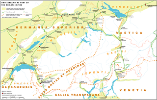
| Description | Switzerland during the Roman aera. Provincial borders between the years 90 and 284 after Christ ( Diocletian 's reform) | |
| Date | ||
| Source | Own work | |
| Author | Marco Zanoli ( sidonius 16:58, 16 July 2006 (UTC)) | |
|
Permission
( Reusing this file ) |
|
|
| Other versions |
|


Licensing
I, the copyright holder of this work, hereby publish it under the following license:
This file is licensed under the
Creative Commons
Attribution-Share Alike 2.5 Generic
license.
-
You are free:
- to share – to copy, distribute and transmit the work
- to remix – to adapt the work
-
Under the following conditions:
- attribution – You must give appropriate credit, provide a link to the license, and indicate if changes were made. You may do so in any reasonable manner, but not in any way that suggests the licensor endorses you or your use.
- share alike – If you remix, transform, or build upon the material, you must distribute your contributions under the same or compatible license as the original.