Homicide_rates_per_100,000_by_state._CDC._US_map.svg

Size of this PNG preview of this SVG file:
512 × 341 pixels
.
Other resolutions:
320 × 213 pixels
|
640 × 426 pixels
|
1,024 × 682 pixels
|
1,280 × 853 pixels
|
2,560 × 1,705 pixels
.
Summary
| Description |
English:
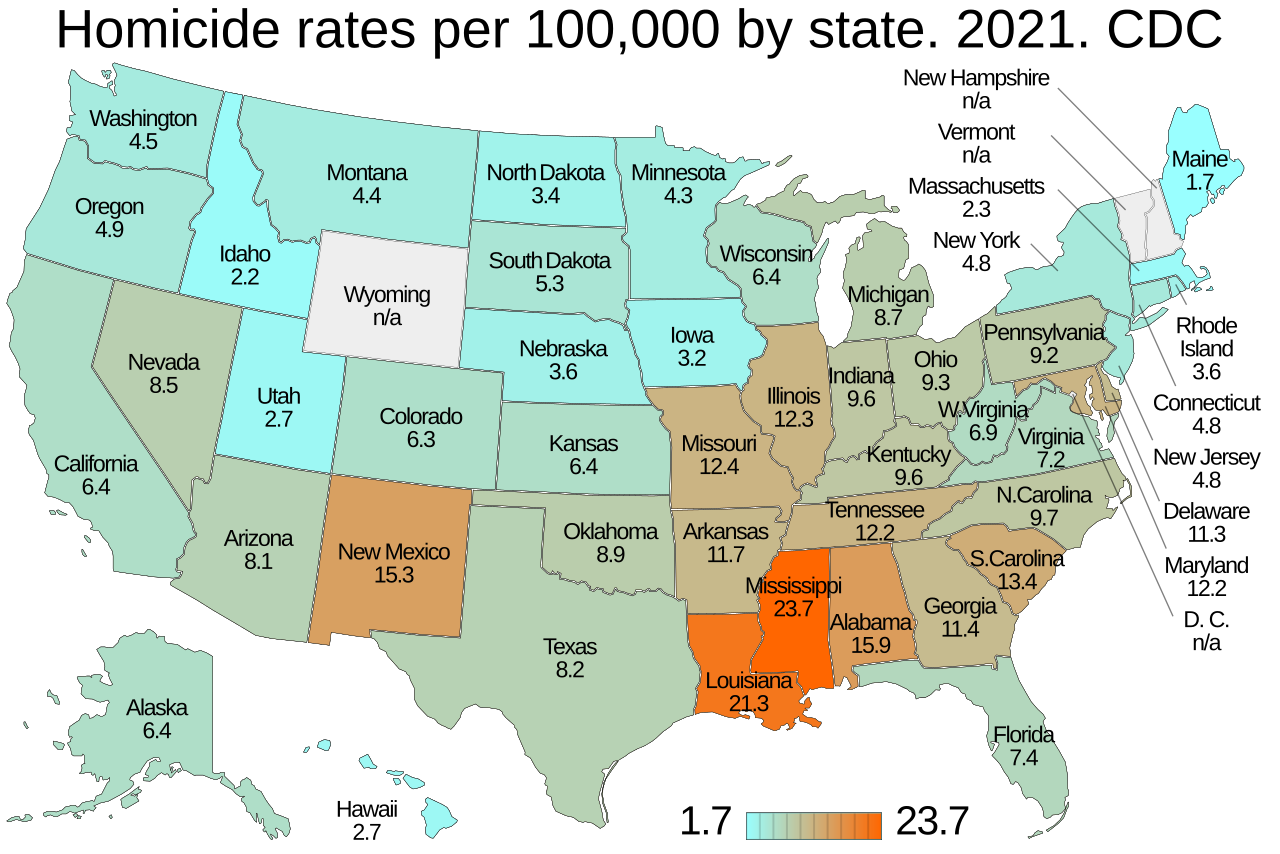
Homicide rates per 100,000 by state. US map. CDC.
Centers for Disease Control and Prevention
. See:
List of U.S. states and territories by intentional homicide rate
. D.C. is specifically not included because it is a federal district consisting of the city of
Washington D.C.
. Being a city, its much higher murder rate skews the 50-state spread for the states.
|
| Date | - date of first upload to the Commons. See file history for later upload dates. |
| Source | Data from Homicide Mortality by State . National Center for Health Statistics . Centers for Disease Control and Prevention . N/A states: New Hampshire . Vermont . Wyoming . |
| Author | Timeshifter from template: File:Template map of US states and District of Columbia.svg . See instructions: File talk:Template map of US states and District of Columbia.svg/Instructions . |
| Other versions | FBI: File:Homicide rates per 100,000 by state. FBI. US map.svg |
Licensing
I, the copyright holder of this work, hereby publish it under the following license:
This file is licensed under the
Creative Commons
Attribution-Share Alike 4.0 International
license.
-
You are free:
- to share – to copy, distribute and transmit the work
- to remix – to adapt the work
-
Under the following conditions:
- attribution – You must give appropriate credit, provide a link to the license, and indicate if changes were made. You may do so in any reasonable manner, but not in any way that suggests the licensor endorses you or your use.
- share alike – If you remix, transform, or build upon the material, you must distribute your contributions under the same or compatible license as the original.