Homo_Sapiens_in_Europe_-_solutrean_distribution_map-en.svg

Size of this PNG preview of this SVG file:
800 × 529 pixels
.
Other resolutions:
320 × 212 pixels
|
640 × 423 pixels
|
1,024 × 677 pixels
|
1,280 × 846 pixels
|
2,560 × 1,692 pixels
|
1,227 × 811 pixels
.
| Description |
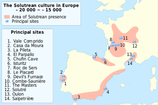
English:
Location map of Homo Sapiens during Solutrean culture, between 22,000 ~ 17,000 BP.
|
||
| Date | |||
| Source | translated from File:Homo Sapiens in Europe - solutrean distribution map-fr.svg | ||
| Author | User:Sémhur & User:MPants at work | ||
|
Permission
( Reusing this file ) |
I, the copyright holder of this work, hereby publish it under the following licenses:
This file is licensed under the
Creative Commons
Attribution-Share Alike
Attribution-Share Alike 4.0 International
,
3.0 Unported
,
2.5 Generic
,
2.0 Generic
and
1.0 Generic
license.
You may select the license of your choice.
|
||
| Other versions | File:Homo Sapiens in Europe - solutrean distribution map-fr.svg |