Itinerario_legazpi.jpg
Size of this preview:
274 × 598 pixels
.
Other resolutions:
110 × 240 pixels
|
328 × 716 pixels
.
Summary
| Description |
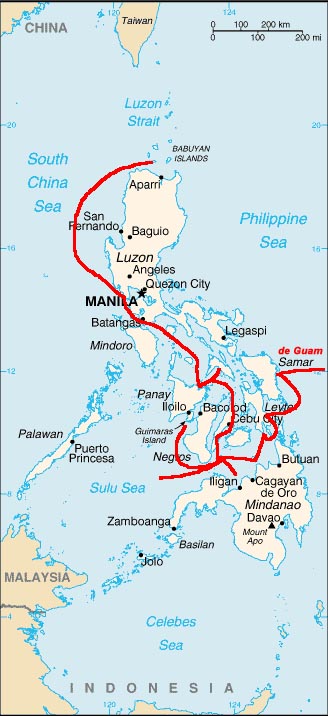
Español:
Mapa del itinerario de la expedición de
Miguel López de Legazpi
en la
Islas Filipinas
(1560s).
English:
Map of the 1560s
Miguel López de Legazpi
expedition, the route of European discovery of the
Philippines
, after crossing the Pacific from the
Viceroyalty of New Spain
(México).
|
| Date | 14 November 2006 (original upload date) |
| Source | No machine-readable source provided. Own work assumed (based on copyright claims). |
| Author | No machine-readable author provided. Txo assumed (based on copyright claims). |
Source
Dibujo propio sobre imagen [1] . -- Txo 22:31 3 noviembre 2006 (CET)
![[1]](https://upload.wikimedia.org/wikipedia/commons/thumb/4/42/Map_Philippines_2005.gif/180px-Map_Philippines_2005.gif)
Licensing
|
|
I, the copyright holder of this work, release this work into the
public domain
. This applies worldwide.
In some countries this may not be legally possible; if so: I grant anyone the right to use this work for any purpose , without any conditions, unless such conditions are required by law. |