Karte_Herzogtum_Bayern_im_10._Jahrhundert.png

Size of this preview:
567 × 600 pixels
.
Other resolutions:
227 × 240 pixels
|
454 × 480 pixels
|
726 × 768 pixels
|
968 × 1,024 pixels
|
1,936 × 2,048 pixels
|
2,844 × 3,008 pixels
.

| Description |
Deutsch:
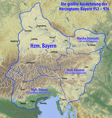
Karte des Herzogtums Bayern im 10. Jahrhundert
|
| Date | see file history |
| Source |
Own work , using
|
| Author | Maximilian Dörrbecker ( Chumwa ) |
|
Permission
( Reusing this file ) |
I, the copyright holder of this work, hereby publish it under the following license:
This file is licensed under the
Creative Commons
Attribution-Share Alike 3.0 Unported
license.
Sie dürfen das Bild zu den folgenden Bedingungen nutzen:
|
| Other versions |
|


|
This
image could be re-created
using
vector graphics
as an
SVG
file
. This has several advantages; see
Commons:Media for cleanup
for more information. If an SVG form of this image is available, please upload it and afterwards replace this template with
{{

vector version available

|

new image name

}}
.
It is recommended to name the SVG file “Karte Herzogtum Bayern im 10. Jahrhundert.svg”—then the template Vector version available (or Vva ) does not need the new image name parameter. |

|
This map has been made or improved in the German
Kartenwerkstatt
(Map Lab)
. You can
propose maps
to improve as well.
|