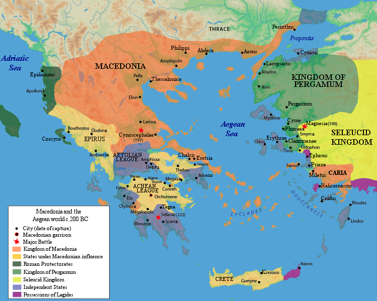
Macedonia_and_the_Aegean_World_c.200.png
No higher resolution available.

|
This
historical map
image could be re-created
using
vector graphics
as an
SVG
file
. This has several advantages; see
Commons:Media for cleanup
for more information. If an SVG form of this image is available, please upload it and afterwards replace this template with
{{

vector version available

|

new image name

}}
.
It is recommended to name the SVG file “Macedonia and the Aegean World c.200.svg”—then the template Vector version available (or Vva ) does not need the new image name parameter. |
Summary
| Description |
English:
Macedonia and the Aegean world c.200 B.C. This image is made by Raymond Palmer.
Español:
Macedonia y el mundo Egeo c. 200 a. C. Imagen creada por Raymond Palmer
فارسی:
نقشه ی سرزمینهای اتحادیه اخائیه در حدود سال ۲۰۰پیش از میلاد به استثنای بوِتیا
|
| Date | Originally uploaded in November 2006 to en:Wikipedia ( log ) by Raymond Palmer ( talk ). |
| Source | R. Ginouvès et al., La Macédoine , Paris, 1992 |
| Author | Kryston |
| Other versions | Italian version |
[
]
-
 български
 -
 català
 -
 Deutsch
 -
 Ελληνικά
 -
 English (PNG)
 -
 español
 -
 français
 -
 русский
 -
 српски / srpski
 -
 italiano
 -
 中文 (GIF)


Licensing
|
|
This work has been released into the
public domain
by its author,
Raymond Palmer
at
English Wikipedia
. This applies worldwide.
In some countries this may not be legally possible; if so: Raymond Palmer grants anyone the right to use this work for any purpose , without any conditions, unless such conditions are required by law. |