Magnetic_North_Pole_Positions_2015.svg

Size of this PNG preview of this SVG file:
401 × 599 pixels
.
Other resolutions:
160 × 240 pixels
|
321 × 480 pixels
|
514 × 768 pixels
|
685 × 1,024 pixels
|
1,370 × 2,048 pixels
|
445 × 665 pixels
.
Summary
| Description |
English:
Positions of
North Magnetic Pole
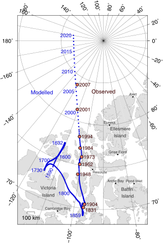
of the Earth. Poles shown are dip poles, defined as positions where the direction of the magnetic field is vertical. Red circles mark magnetic north pole positions as determined by direct observation, blue circles mark positions modelled using the GUFM model (1590–1890) and the IGRF-12 model (1900–2020) in 1 year increments. For the years 1890–1900, a smooth interpolation between the two models was performed. The modelled locations after 2015 are projections.
Українська:
Північний магнітний полюс, що розташовується на Землі. Магнітне поле показує диполь, визначений позиціями де напрям магнітного поля вертикальний. Червоні кільця позначки північного магнітного поля визначені прямим спостереженням, голубі кільця позначки позиції змодельовані GUFM модель (1590-1890) та IGRF-12 (International Geomagnetic Reference Field Model) модель (1900-2020) з кроком в один рік. Для років 1890-1900, гладка інтерполяція виконана між двома моделями. Змодельовані місця після 2015 року є проекціями.
Русский:
Географическое положение
северного магнитного полюса Земли
. Полюса, показанные на карте, подразумеваются полюсами
магнитного диполя
, и в точках их расположение
наклонение
магнитного поля вертикально. Красными кружками обозначены места, обнаруженные прямыми наблюдениями. Синие кружки - места, вычисленные по моделям «GUFM» (1590–1890) и «
IGRF
-12» (1900–2020) с временным шагом в 1 год. Для 1890–1900 годов, была осуществлена плавная
интерполяция
между двумя моделями. Смоделированные положения после 2015 года - предположительны.
|
| Date | |
| Source |
Own work
|
| Author | Cavit |
| Other versions |
|
| SVG development |

Licensing
I, the copyright holder of this work, hereby publish it under the following license:
This file is licensed under the
Creative Commons
Attribution 4.0 International
license.
-
You are free:
- to share – to copy, distribute and transmit the work
- to remix – to adapt the work
-
Under the following conditions:
- attribution – You must give appropriate credit, provide a link to the license, and indicate if changes were made. You may do so in any reasonable manner, but not in any way that suggests the licensor endorses you or your use.
GMT Source Code
GMT (Generic Mapping Tools), http://gmt.soest.hawaii.edu/ archive copy at the Wayback Machine
@echo off
set PS=magpole2.ps
pscoast -Di -JE-90/90/10c -R-115/66/30/84r -Bxa20g10 -Bya10g5 -A150 -L-113/68/80/100 --MAP_POLAR_CAP=none --MAP_FRAME_TYPE=plain --MAP_FRAME_PEN=0.6p -G224/224/224 -W,130/130/130 -Swhite -K > %PS%
psxy NP.xy -J -R -O -K -Sc0.1c -G10/10/220 >> %PS%
psxy observations.txt -J -R -O -K -Sc0.23c -G240/117/104 -Wthick,0/0/0 >> %PS%
pstext -J -R -Dj0.15c/0.05c observations.txt -F+f11,Helvetica,60/0/0+j -O -K >> %PS%
pstext -J -R -Dj0.15c/0.05c modellabels.txt -F+f11,Helvetica,10/10/220+j+a -O -K >> %PS%
pstext -J -R legend.txt -F+f -O -K >> %PS%
psxy cities.txt -J -R -O -K -Sc0.1c -G0/0/0 >> %PS%
pstext -J -R cities.txt -F+f8,Helvetica,50/50/50+j -Dj0c/0.1c -O -K >> %PS%
pstext -J -R labels.txt -F+f10,Helvetica,50/50/50 -O >> %PS%
}}
}}

==observations.txt==
Observed pole positions taken from Newitt et al., "[http://www.terrapub.co.jp/journals/EPS/pdf/2009/6106/61060703.pdf Location of the North Magnetic Pole in April 2007]", Earth Planets Space, 61, 703–710, 2009

<syntaxhighlight>
-120.72	83.95	LM 2007
-110.80	81.30	LM 2001
-104.0	78.30	LM 1994
-102.3	77.0	LM 1984
-100.6	76.0	LM 1973
-100.8	75.1	LM 1962
-100.9	73.9	LM 1948
-96.6	70.5	LM 1904
-96.9	70.1	LT 1831