Manatvs_gelegen_op_de_Noot_Riuier.jpg

Size of this preview:
800 × 575 pixels
.
Other resolutions:
320 × 230 pixels
|
640 × 460 pixels
|
1,024 × 736 pixels
|
1,280 × 920 pixels
|
2,560 × 1,839 pixels
|
8,752 × 6,288 pixels
.
| Warning | The original file is very high-resolution. It might not load properly or could cause your browser to freeze when opened at full size. |
|---|
| Description |
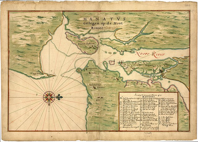
"Manatvs gelegen op de Noot [sic] Riuier" - a Dutch map of Manhattan and environs from around 1670, believed to be a copy of a 1639 map often attributed to
Johannes Vingboons
(a.k.a. Joan Vinckeboons).
[1]
|
|||||||||
| Date | c.1670 (believed to be a copy of a 1639 map) | |||||||||
| Source | Image of map at Library of Congress ( [1] ). | |||||||||
| Creator |
sometimes attributed to Johannes Vingboons
|
|||||||||
| Geotemporal data | ||||||||||
| Bounding box |
|
|||||||||
| Georeferencing | ||||||||||
- ↑ (2009) Half Moon: Henry Hudson and the Voyage that Redrew the Map of the New World , Bloomsbury Publishing USA, p. 278 ISBN : 1608190986 .
|
|
This work is in the public domain in its country of origin and other countries and areas where the copyright term is the author's life plus 100 years or fewer . |
| This file has been identified as being free of known restrictions under copyright law, including all related and neighboring rights. | |