Map_of_Gascon_campaign_of_1345.svg

Size of this PNG preview of this SVG file:
552 × 599 pixels
.
Other resolutions:
221 × 240 pixels
|
442 × 480 pixels
|
708 × 768 pixels
|
943 × 1,024 pixels
|
1,887 × 2,048 pixels
|
914 × 992 pixels
.
Summary
| Description |
English:
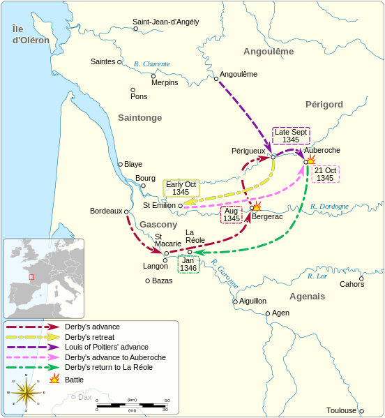
Map of the Gascon campaign of 1345, part of the Hundred Years' War. This map shows the English and French army movements during the campaign and the most important battles.
Català:
Mapa de la campanya gascona de 1345, part de la Guerra dels Cent Anys. Aquest mapa mostra els moviments de l'exèrcit anglès i francès durant la campanya i les batalles més importants.
|
||||||||||||||||||||||||
| Date | |||||||||||||||||||||||||
| Source |
Own work
Derived from; Information from:
|
||||||||||||||||||||||||
| Author | Goran_tek-en | ||||||||||||||||||||||||
|
Permission
( Reusing this file ) |
This file is licensed under the
Creative Commons
Attribution-Share Alike 4.0 International
license.
Attribution:
Goran tek-en
|
||||||||||||||||||||||||
| Other versions |
File:
Map of Gascon campaign of 1345.svg
has
1 translations
.
|
||||||||||||||||||||||||
| SVG development |
This
vector image
was created with
Inkscape
.
|
||||||||||||||||||||||||


| Object location |
|
View this and other nearby images on: OpenStreetMap |
|
|---|

